This discussion has been locked.
You can no longer post new replies to this discussion. If you have a question you can start a new discussion

Problem with ClimbPro

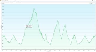
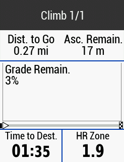
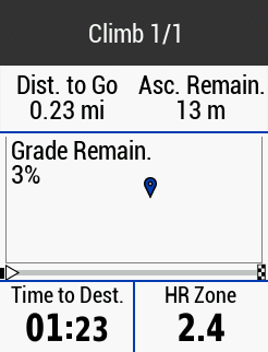
I have a problem with navigation and ClimbPro. When an ascent is approaching ClimbPro is activated and shows me data and profile, but when I reach the beginning of the ascent and the "Go" message disappears the profile drawing also disappears and that area of the screen remains empty, so I only have the numerical data of how much distance Ihave left and how many meters of ascent to climb. This has been happening to me for several months and I thought It would be a bug in some firmware version but several versions have passed and the problem in my 830 continues. I wanted to know if this happens to more people or just me, and of course if there is any way to fix it. Thanks.

  • This is the profile in Basecamp.

  • Thanks. I have raised a support with Garmin on this.

  • I did not expect to get any screenshots of this happening until next month when I have a very hilly event. But today I was surprised to see it happen on my own patch where it has never happened before on a small hill very close to home. As I was not expecting it, I was not prepared but managed to get a screenshot.

    This was on a new course I created this morning. It was created in Garmin Mapsource using a "Talky Toaster" OSM map.
    The map in use was a Garmin EU map West. This is with a Garmin Edge 530, not the 830.

    On approach, to the hill, the profile was shown in the prewarning notification. But, soon as the climb started, the profile vanished.

    I was too slow to switch page to the elevation profile but captured it on the way back descending the hill and it just shows a flat line.

    One without my icon marker and one with. The marker is not present all the time but flashes on and off.

    The Map in use: -


    The elevation profile as I am about to descend the same hill on the return journey, The map that the course was created on, does have elevation data and does show a profile, Sadly, I deleted the original course after uploading to the Garmin, but recreating it when I got home showed the climb: -

  • The Edge is currently not fully handling course files that do not contain elevation data. When previewing climbs it replaces the missing data with data from the DEM file, which is why you see Climb(s), but when on the climb and executing the course it goes back to using the course file. Hence no elevation profile on the ClimbPro page and the flat line on the elevation page.

    As I mentioned above I have raised a ticket with Garmin on this. The only current work around is to create the course using a tool/site that actually adds the elevation data to the course file. Most site do this, it appears to be Garmin Basecamp and from your report above Garmin Mapsoure that do not.

  • "The Edge is currently not fully handling course files that do not contain elevation data."

    That seemed a perfectly logical answer, but I suddenly realised, the only program I use for route planning etc, is Garmin Mapsource, it is very very rare for me to use anything else as I like to plan my routes on my own PC and using the same maps that I will be using on my Edge for 100% compatibility.

    The only reason that I was using the Garmin EU map was because when I rode London Edinburgh London recently, there was a part of the UK that I had not installed enough of the Talky Toaster OSM map to give me full coverage of the route so I had to change maps and forgot to change back to the TT OSM map.

    But the question is, if Mapsource does not provide elevation data into a course file, then why am I not seeing this error in Climb Pro on every hill, instead, it is only now and then. I can ride a very hilly ride and every climb is ok, and another ride, just one hill may have this error but every other hill is ok but in theory they should not be as the course should have no elevation data.

    I think there is another issue somewhere contributing to the error. 

    Now I have found a hill it happens on, I will experiment with different programs and map combinations, ie the course I rode today, may or may not work on the TT map.

  • I would need to see the course files to get a better idea.

  • I'm pulling my hair out to try and get anything to work this morning, Edge does not want to connect to PC, then it does, then it doesn't, Mapsource will not save me files, not able to get the Edge to detect the hill I used yesterday in climbpro unless it's part of a very long ride, TT OSM no longer has DEM information it appears so I cannot test if Mapsource includes DEM info in a course etc.

    2 hours off wasted time for such a simple task, I feel like launching the Edge through the window..

    Going for a ride to test what I have and calm down.

  • it appears to be Garmin Basecamp and from your report above Garmin Mapsoure that do not

    It is a very logical explanation, yet you can make Garmin Basemap (GB) include elevation data in exported course, at least in the following scenario:

    1. Make sure that active map in GB has elevation data embedded in it. Notice that Garmin Cycle Maps EU East/Central/West do not carry elevation data.
    2. Make "New Route" then "Create track from selected route" when ready.
    3. Copy to Edge device.
    4. There is a track.gpx file created. It contains multiple <trkpt lat="yyy" lon="xxx"><ele>zzz</ele></trkpt> elements.

    , regarding your setup, you have enabled "Garmin Cycle Map West" which has no elevation data. You disabled "Garmin DEM map" which has elevation data for cycle maps (or any other map that comes with no elevation data). If you had no other map with elevation data enabled then your edge device has no elevation information for its maps.

  • Follow up: there is no elevation data if you copy route to edge in the scenario above; except for for the points you clicked on the map while drawing your route (like start and end points). You have to create track out of it to get elevation data in the file.

  • "regarding your setup, you have enabled "Garmin Cycle Map West" which has no elevation data. You disabled "Garmin DEM map" which has elevation data for cycle maps (or any other map that comes with no elevation data)"

    I went out today and tried everything I could to get ClimbPro working to display the profile, including enabling every map including "Garmin DEM" and nothing. The profile would show, soon as "Go" showed, the profile vanishes.

    I have also realised that I had a big clear out of OSM maps including TT OSM in July to remove all clutter for riding LEL. What I think has happened, the version of TT OSM that I have been using on the Edge and in Mapsource was a version with DEM as versions of it now no longer has DEM and now, I have a copy of this new version on the Edge and in Mapsource.

    But it has been a bad start to the day this morning and when I finally set off for my ride, within 200 yards, I had two punctures.
    Tomorrow has to be a better day.