This discussion has been locked.
You can no longer post new replies to this discussion. If you have a question you can start a new discussion

Navigation question

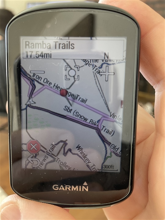
Question about navigating on trails.  The picture is an example from the other day when a group of us did a ‘virtual’ snowbike race.  The darker pinkish line with black border is where we were supposed to go and the lighter pink line usually is essentially on top of it but sometimes it goes slightly different?  What’s the difference between the two lines and why does the lighter line sometimes not follow and >95% does?  I have “popularity routing” turned off and also recalculation off.  I guess after some head scratching in the woods I learned to follow the darker one but just trying to understand that lighter one?  Thanks!

  • It looks to me like there is a problem with the map data that prevented the device from navigating the course you want.  For example, if there's a discontinuity in the data for a road or trail, even though there isn't one in reality, the device will navigate around it.  I lay out my courses on a computer, and if needed, force the route where I want it to go.  The Edge will navigate these routes correctly.

  • The lighter line is what the Garmin calculates as the route using the map by following your track. Basically, it's a second track.

    For that to work correctly, your track has to follow roads (that can be used) on the map. (It doesn't have to follow exactly but it has to be kinda close).

    The problem is that your track follows a road that is indicated in Openstreepmap (OSM) as "private". The Garmin router won't use private roads (so, it's as-if those roads do not exist).

    My position is that the router should ignore the "private" attribute and trust that you knew what you were doing when you created the track (course).

    If these roads are not private, that should be updated on OSM.

  • I agree that if you load a route then Garmin should follow that route and not recalculate the route.

    I've found that when I navigate to a saved location that my Garmin ignores private roads and gates. Yes, I checked the attributes on OSM. It's interesting that it honors those attributes when recalculating a route.

  • The Garmin map probably has those details omitted.  If you use other maps with those features than they will likely be correctly routed around.

    Garmin cycling units do ignore no cycling restrictions on paths even when the paths are correctly marked in the map though.

  • So I guess the moral of the story is if/when this happens again just follow the darker line?  This was my first time REALLY navigating in the woods with the 830 and not in obvious easy places like roads.  I was riding a provided .gpx file for the event and even if there was a private area we were on a marked trail system so i'm quite sure everything in that regard was on the up and up.

    Thanks for the info

  • So I guess the moral of the story is if/when this happens again just follow the darker line?

    Yes.

    The darker line is the primary information. It really won't ever be wrong (that is, it will always be what you load). The lighter line is a secondary track. It's correctness depends on the map (and map version) installed on the device.

  • This doesn't work in my experience... Like you, I also lay out my courses on my computer (in RideWithGPS) and commonly force the route to go where I want it to go. However, once I start my actual ride, the Edge does NOT navigate the route correctly. Instead, I get several instructions for U-turns that are completely bogus, and the device always seems to tell me to take a busy road instead of the wide, paved, very nice bike path that's 50 to 100 meters from the road and parallel to it; the path even goes all the way to my destination! My wife experiences the same problems. We both consider this a failure on Garmin's part, especially since we've tried a multitude of different settings and profiles to fix this. Nothing has worked.

  • What map are you using in RWGPS?

  • Yep.  You can lay out a course on any other platform and Edge takes those track points, matches them up to its map, for better or worse, and generates nav instructions based on those results.  If there are errors or probs with the Edge map, those will show up as wack nav instructions. .  

  • I use several different maps in RWGPS and have a "premium" account there. Sometimes, Open Street Map - Cycle will show a trail or path that's not shown in any of the other maps. Other times, Google Maps shows a trail or path that isn't marked on any of the other maps. On occassion, I even have to call up the satellite imagery to lay out a portion of a course I'm planning. Once I start my actual ride, if I'm the "entity" that planned/created the course, I really expect that the Edge ought to obey my design. Afterall, I designed the course (sometimes with a great deal of research) and I'm smarter than the computer. In this situation, I really have a strong expectation that the Edge should guide me through the course I created.  It's where I want and sometimes need to ride. Case in point, in some places, cycling on a path (and not the road) is required by law -- especially in Germany. On the other hand, if I'm in the middle of a ride (with or without a course), and I suddenly want/need to ride to some place I didn't anticipate, then I'm happy to take whatever route the Edge lays out.