This discussion has been locked.
You can no longer post new replies to this discussion. If you have a question you can start a new discussion

Navigation question

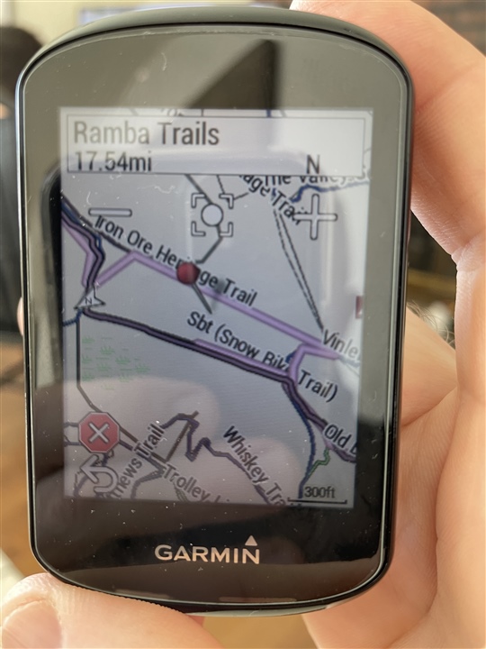
Question about navigating on trails.  The picture is an example from the other day when a group of us did a ‘virtual’ snowbike race.  The darker pinkish line with black border is where we were supposed to go and the lighter pink line usually is essentially on top of it but sometimes it goes slightly different?  What’s the difference between the two lines and why does the lighter line sometimes not follow and >95% does?  I have “popularity routing” turned off and also recalculation off.  I guess after some head scratching in the woods I learned to follow the darker one but just trying to understand that lighter one?  Thanks!

  • The Garmin maps are based on OpenStreetMap data so you should do your route planning using OSM maps.

  • The Edges don't work that way.

    "Turn guidance" (the big white arrows) is calculated on the device using the installed map.

    It basically follows the track (from the file) and pick the roads/paths the track appears to be tracing.

    If there are no nearby roads/path, it will deviate from the track.

    Originally, people got tracks from recording a ride (rather than using a program to create them).

    The Edges end-up using two lines for navigation: the original track and the second calculated one.

     The devices can tolerate some map differences but they can end up picking the wrong way if it's close to another.

    Ideally, you'd use the same to plan the route as what is installed on the device (Openstreetmap).

    You do have to use another map if OSM is missing the feature you want to use but you just have to deal with the device calculating a deviation.

    Thus is one reason I kept an eye on the map. I can usually spot upcoming issues and handle them.

  • Wow this is an old thread, but came to check because of emails saying that there were responses.  At some point after verifying with a friend that his Edge 830 did not add these extra lines we found a separate menu selection that got rid of it.  I only use the navigation part of my Edge following routes off road and this has been a pain when it's trying to direct you somewhere off course.  Anyways to get it off go to Navigation -> Courses -> Saved Courses and then there is the 3 line "hamburger" thing on the bottom right.  Go into that menu and turn off Turn Guidance and the second incorrect line goes away. 

  • Thanks, this a help to a fellow mtb guy!  I also found I can turn of the "Off Course" warnings in the same place.

  • FWIW:  Mtbing, I usually just display the course on the map rather than use navigation.  Depending on the trails and corresponding map data used when laying out the course and what's resident on the Edge, Nav can be especially wack.