This discussion has been locked.
You can no longer post new replies to this discussion. If you have a question you can start a new discussion

navigating a course

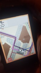
I created a track (gpx) in Basecamp. When I choose " navigate course" from menu (saved file), the Edge 830 decides to create it's own directions as shown in the picture. The darker line is my gpx course and the pink line is the suggested /calculated route. When asked to follow a saved route I would excpect the 830 to follow instructions.

I  have no clue in how to make the 830 behave different and follow a course. I would expect an option like  "no calculation" or follow/ stick to course.

My relevant setting are:

Trendline: off
Route modus: mtb
Caclulation method: minimal distance
On road:off

Map active:  Open Bicycle (fiets) Map BNL (routable) 

.
Top Replies

All Replies

  • sended pic + location

    the yellow line is the route which the edge ceates on the open bicycle map, the pink track is the created/intended course.

  • Thanks for the extra info. It's hard to talk about these sorts of things without it.

    ===============

    The calculated routing strongly prefers following roads/paths. That's what is happening in this case. (I'm not surprised at the result here: it seems normal to me,)

    The devices will give-up trying to follow roads if there are no roads "nearby" (and pick up routing when the track starts following roads again) but that's not the case here.

    If your track has these sorts of diversions, you are going to have to pay attention to the map. I think navigation works better when one looks at the map fairly frequently. It's fairly easy to miss turn announcements. So, looking at the map is a useful backup.

    Anyway, looking at satellite view on Google maps, the track seems a bit wacky (it appears to go through gardens and bushes).

    Your screen shot (sent privately) shows BaseCamp doing the same thing.

    The other map (topo) might not have the service roads in the parking lot as routable. Or there's some other difference (since I can't see the maps, I don't know). A topo map is not exactly the usual sort of map to use in these kinds of places anyway.

  • Turn guidance is possible for Topo map only The other maps leave me on track once the  guidance is turned off.

    The turn guidance option did not came on my radar until you pointed that out, thanks!

    Funny fact is that an older device , 60csx, has track following option called backtrack and this worked like charm with guidance! Point to point ! Making gpx tracks with to many points would drive you crazy.

    The track might look wacky on google but I can walk it without trespassing Slight smile

  • The 60csx might be using something like “course points”, which doesn’t rely on maps at all. The Edges support course points. Or, it is using waypoints.  

    The Edges approach navigation differently than the hiking units.

    I believe the hiking units can use files that have waypoints (ridewithgps calls them “route” files) but the Edges can’t use them at all. With route files, the device calculates a path between each waypoint. 

    Course points just announce when you reach them. 

    The Edges are focused on riding. Your track might be ok for walking. 

  • I believe the hiking units can use files that have waypoints (ridewithgps calls them “route” files) but the Edges can’t use them at all. With route files, the device calculates a path between each waypoi

    My gpx files from my csx60 time are stored in Basecamp  (as Tracks) and stil being used for the 830 nowadays. There is no difference for me in how I use them aside from device specific features.

    here is some nice documentation (translate from Dutch) https://www.javawa.nl/begrippen.html

    The Edges are focused on riding. Your track might be ok for walking.

    I can walk or ride this track, does not matter.

  • I can walk or ride this track, does not matter.

    The unit does know that.

    That page doesn't appear to provide much insight into this issue.

    Anyhow, what happened in this case is normal behavior. It even makes some sense (even if it's not the behavior you want)....

    After some research, it does not seem the csx60 generates "turn guidance" that follows a track. (Maybe, that's wrong. It's hard to find anything that is clear about it.) If the csx60 doesn't do that, then the 830 is doing something quite different.

    "Backtrack" appears to be guidance to a point on the track (which is different from guidance that follows a track, the thing being discussed). The Edges can also calculate a route to a point (you just can't pick the point on a track).

    www.manualslib.com/.../Garmin-Gpsmap-60csx.html

  • I believe the hiking units can use files that have waypoints (ridewithgps calls them “route” files) but the Edges can’t use them at all. With route files, the device calculates a path between each waypoint. 

    that sites explains exactly the problem you are talking about. one of the tools reads both formats and allways saves in Garmin compatible mode

  • It doesn't help because it's either talking about stuff I know about and nothing about what the csx60 does.

    It says nothing about the issue you brought up. (Not to say it's not useful otherwise.)

    I know what route files are (not everybody reading this thread will). And I know you can convert route files to tracks (this is what all route planners do).

    The Edges can't use route files anyway (they only use tracks).

  • I said so in answer to your believings. And a forum is a place where subjects boundaries are not so tight as c++ development.