This discussion has been locked.
You can no longer post new replies to this discussion. If you have a question you can start a new discussion

navigating a course

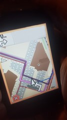
I created a track (gpx) in Basecamp. When I choose " navigate course" from menu (saved file), the Edge 830 decides to create it's own directions as shown in the picture. The darker line is my gpx course and the pink line is the suggested /calculated route. When asked to follow a saved route I would excpect the 830 to follow instructions.

I  have no clue in how to make the 830 behave different and follow a course. I would expect an option like  "no calculation" or follow/ stick to course.

My relevant setting are:

Trendline: off
Route modus: mtb
Caclulation method: minimal distance
On road:off

Map active:  Open Bicycle (fiets) Map BNL (routable) 

.

Top Replies

All Replies

  • It would be helpful to know the location.

    The routing tends to have more issues in places with lots of alternative ways close together.

  • location = Top Secret! :)

  • I tried with a different map active , Topo pro Benelux, and for now now it seems to follow the original track/course without recalculations or different route..

  • It looks like there was a problem with the map. That's easy to fix (if you know the location).

    You could have sent the location as a private message.

  • Not a problem with the map itself.

    Both of the OFM (open bicycle) maps  deviate on TO MANY points from the track/course I designed, as where a Topo map does not, not even on non-paved areas (offroad).
    The way maps behave and should be utilized is far undocumented as far as that I know of for some reason.
    There must be an obvious reason that Offroad navigation is possible on a Topo Map, which this device is supposed to do in the first place.

    I would like to know what makes offroad navigation possible so that the course is not being deviated from the created and intended track.

  • There are two modes of navigation:

    1- track following. This doesn't use maps. It's truly "off road". ("Course points" are part of this mode.)

    2- "turn guidance" (Garmin's term). This uses maps and follows the roads/paths on the map. This is always "on road" unless the there aren't any roads/paths near the track. Turn guidance is the big white arrows and you can turn it off.

  • what makes the 830 go follow tracks instead of turn guidance? turn of the maps or use non routable maps? this for the sake of visual satisfaction and indirect guidance plus awarenes?

    my topo BNL map gives directions now and then, plus it follows me offroad when needed without complaining. Does not fit the picture though as it is routable to.

  • On the 1030 (the 830 should be similar):

    Saved Courses -> menu at lower right (the three horizontal lines).

    Turn Guidance -> Off

    Off Course Warnings -> On.

    If you want "Course Points", change that in the settings for the particular course.

    ==================

    The device generates the instructions for "turn guidance" by walking the track and picking the roads/paths that the track appears to follow. If there aren't any reasonable roads/paths to pick, it can't generate instructions. It should give up and resort to basic track following. The "turn guidance" is actually a second track that the device generates and uses.

    The older units didn't handle that situation very well. It wasn't too big a deal if one was used to looking at the darker path.

    I don't know how the newer units handle it (hopefully, better).

  • But why the difference between Open Bicycle Maps and the Topo Pro maps ?

    Bicycle Maps turns away from the initial track per guidance where Topo map does not. For both maps turn guidance was on.

  • The maps are different. Topo maps are not usually used for road use.

    I don't have the topo maps (so I can't check them).

    I don't have the location (so I can't check the OSM maps).