My typical workflow for road rides is as follows:
- Create course using plotaroute
- Export as GPX without turn-by-turn directions or waypoints
- Copy to Garmin via USB or bluetooth as appropriate
This creates me a breadcrumb trail, which the 830 also uses to generate turn-by-turn instructions. This works very well and I'm happy with it.
The problems start when you go off course. As a good example, at the weekend I deviated from my course - the deviation was around 2-3 miles long and the new and plotted route went more or less in the same direction, reconverging at a village further ahead. My Edge 830 asked if it could recalculate the route (I have it set to prompt so I can see what it's up to), to which I said "yes". It then went through the following stages of rerouting, constantly asking me if I was OK to reroute:
- Perform a U-turn!
- Perform a U-turn!
- Perform a U-turn!
- Continue straight on
At this point, I assumed it had sorted itself out and when I reached the junction at the end of the road, I stopped to check.
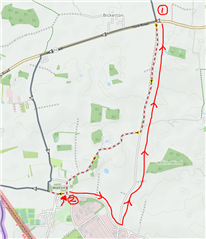
Here is the route as plotted (solid line, heading West and South). I was heading South and diverted from the plotted route at (1) and rode the dotted line to (2). When I stopped at this point, expecting the Garmin to ask me to turn right to rejoin the original route, it had actually plotted the red line back to (1), where I left the original route:
Am I missing something here, or are there settings that can improve the way this works to make it more usable? Is this a limitation of course-following, where it will assume that you will never, ever deviate from the plotted course?