This discussion has been locked.
You can no longer post new replies to this discussion. If you have a question you can start a new discussion

Navigation Rerouting - bit rubbish, or am I missing something?

My typical workflow for road rides is as follows:

  • Create course using plotaroute
  • Export as GPX without turn-by-turn directions or waypoints
  • Copy to Garmin via USB or bluetooth as appropriate

This creates me a breadcrumb trail, which the 830 also uses to generate turn-by-turn instructions. This works very well and I'm happy with it.

The problems start when you go off course. As a good example, at the weekend I deviated from my course - the deviation was around 2-3 miles long and the new and plotted route went more or less in the same direction, reconverging at a village further ahead. My Edge 830 asked if it could recalculate the route (I have it set to prompt so I can see what it's up to), to which I said "yes". It then went through the following stages of rerouting, constantly asking me if I was OK to reroute:

  1. Perform a U-turn!
  2. Perform a U-turn!
  3. Perform a U-turn!
  4. Continue straight on

At this point, I assumed it had sorted itself out and when I reached the junction at the end of the road, I stopped to check.

Here is the route as plotted (solid line, heading West and South). I was heading South and diverted from the plotted route at (1) and rode the dotted line to (2). When I stopped at this point, expecting the Garmin to ask me to turn right to rejoin the original route, it had actually plotted the red line back to (1), where I left the original route:
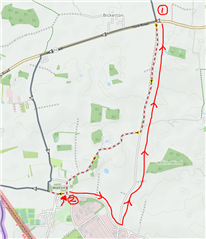
Am I missing something here, or are there settings that can improve the way this works to make it more usable? Is this a limitation of course-following, where it will assume that you will never, ever deviate from the plotted course?

  • Yes, allowing these devices to recalculate the route if you go off course is not usually the best way to go.  This has been the case for years.  It is best just to not recalculate and get yourself back on the course and then the device will carry on navigating you along the course.

    Using the recalculate option will have the device plot a new route to the end point of the course, not back onto the original route at a suitable future point.  The new route could line up with the original one but is unlikely to.

  • Does the same in BaseCamp when using the Garmin Cycle Map.  Its getting to become a tedious and sad state of affairs to have to have recommend that people don't use the built-in maps on their devices but download other ones like Openfiets or OpenTopo.  Both of those maps select the minor/unclas road instead of the tertiary one. Frowning2

    Underlying OSM map data looks all ok to me.  The tertiary road has a speed limit set at 60mph, other than that no access restrictions or unpaved elements.  I’m looking into the styles for both of those to try and understand why but without the corresponding Garmin Style its hard to make direct comparisons.  Maybe the Garmin interpretation of the map data just bumps the Tertiary Road higher up the pecking order to such a degree that it thinks it’s the best and fastest route.

    http://garmin.openstreetmap.nl/

    http://garmin.opentopomap.org/

  • It's more than a bit rubbish, it's a lot rubbish

  • I used to have it on "prompt" for a while... with sub-par or terrible results almost always (road cycling). Now it's disabled and on the list of Garmin selling point features that don't work. Not helpful, I know.

    My new approach: zoom out and search my way, combined with mild buyer's regret. 

  • Its ok, it will all be fixed in the new 1030 plus.Rolling eyes

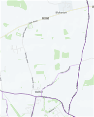
  • Ok, one thing i didn't originally consider is the Popularity Heatmap.  This is the Garmin map for that area.

    As you can see the tertiary route is more popular with other cyclists in that area.  It may be that this layer is weighting the tertiary road up the food chain rather than the unclassified road and hence the routing decision you saw.

    I'd have to test on the Edge using course points to see how it behaved with and without that heatmap enabled.

  • Interesting point, thanks.

    It complained most of the way down Rudgate, trying to get me to U-turn, and only finally stopped when we turned onto Hall Park Road into Walton, at which point it created a route that looped into Walton, East on Wighill Lane and then back up Rudgate to the point on York Road where we left the route. It's pretty crazy behaviour when it's recalculated route passed so close to the original route in Walton.

    Is the popularity heatmap loaded onto the device and can you turn it on and off? (apologies, my device isn't to hand at the moment so I can't check!)

  • I have never not seen it be rubbish and behave as you describe.  I suspect whoever coded it assumed you wanted to ride your entire route and not miss any of it so it sends you back to were you deviated from it.  I always just look at the map and decide for myself how to rejoin the course.  Once back on the course, it picks up nav again.

  • Yes, to be fair this would be how I would normally ride and in this case, I was performing a bit of an investigation to see what happened. Fortunately, it's quite unusual for me to deviate heavily from my courses as often there are relatively few other options to take. It also helps that most of the time, I've ridden these roads hundreds of times so getting lost really isn't a problem :-)

    Perhaps this is indeed the behaviour when following a plotted course. It's a shame if it is...

  • I just saw the preview of the Garmin 1030 plus from Shane Miller and the 1030 plus has 3 different rerouting options. To the Garmin guys: will we get this on the 830 too? Would be great!!