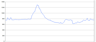
I drove a planned route 1300 meters in altitude yesterday. The Edge indicated over 2000 meters of altitude beforehand. Climbpro showed both gradients and descents as gradients. Is there a solution for this.
The issue is likely due to the quality of the elevation data in the course file.
Where was the course created and how did it get to the Edge?
The course was downloaded and directly send to Edge as a GPX file. The file was not created by me. But from a hotel that specializes in road bike tours.
Could you post the GPX file or tell me which course it was.
I can not insert the file, but the name of the tour is: GROSSE LOFERRUNDE
I can make some, if you'd like. GC course says almost 4000m, and in reality it's something like 800m. I drove it, so I know.
There are some weird spikes of about 120m on flat terrain, so that throws the whole course off.
It looks like bad elevation data in the file
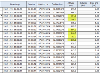
interesting, thank you. Is there a way to find and fix something like this easily?
Yes, there is. You can read it in my post in the 1030 section:
Please scroll down to the last part. You have to convert your GPX file to TCX. You can do so by loading it in BaseCamp, save as TCX, then adjust the values with notepad or another editor. For the rest you can follow the way described in the post.
Good luck!
You can edit GPX files using an editor, but you would need to know what elevation values to change.
Anything with with a large change is suspect.