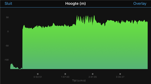
Anyone familiar with changing elevation with the 830? Sometimes up en down in a range of 10 meters. Sometimes enormous leaps by 100 meters 
I don't consider that when the unit cools down it 'suspects' you are cycling a mountain. Apart from the fact the unit does not think it could as well mean that either the barometer sensor or its electronics around is not properly temperature compensated (the temperature as such does not change the pressure), or the pinhole to connect outside pressure to the barometer sensor is too small and it takes too long of a time till the pressure inside / outside equalizes after a temperature change of the air trapped inside the unit.
Just my two cents....
I am not sure; did I state that?
When a pressure sensor is used to measure air pressure and by that altitude, there is no need for a ambient air temperature derived altitude. This would not work anyway.
Imagine you are starting a ride early morning with temperature 6°C, riding flat and during the day the temperature rises to 25 °C; would you expect or appreciate your Garmin telling you that your elevation had decreased just by temperature change?
What I indicated is that an air pressure sensor should be compensated for temperature changes of the sensor itself, leading to incorrectly interpreted changes in height. This means that ideally if only the temperature of the sensor changes (sitting in the sun, raising temperature during the day etc.) and the air pressure remains exactly the same, the indicated height in the Garmin should not change by that.
To linger a bit on on this topic: during the day the atmospheric pressure may change regularly: just the daily cycle where sun heat affects wind patterns and air pressure, the passing of a weather front, thunderstorm etc. Remember that 1 mbar change in air pressure (compared to the average 1013 mbar at sea level, so 0.1%) equals a change in height of 10 meter already.
Further: the rule of thumb that every increase in height of 100 m equals a temperature drop of 1°C is very inaccurate. Sun and daily temperature cycle disturb this 'rule' and as well with humid air, when water vapour condenses when air rises, the temperature drop might well be only 0.7 °C/100 m. This makes temperature reading as an height indicator useless.
So if Garmin would use that, I am sure they do that in a wrong way.

I've replaced 2 devices now because of completely erroneous elevation tracking. The newest device does elevation much better, but is very broken in other ways. Most recently, I've had one device on v5 perform horribly at elevation tracking, and the replacement device do much better. Also on v5. So, it might actually be a hardware issue.
Hello, Same here, I bought my 830 in September 2019, until middle of may it was ok, now i have altitude issue, even without moving i have a drift of +/- 70 m, when I ride I can have 200 m difference, grade are inverted, last WE i have updated to 5.5 and i have done a cold start to be sure ! May it is more a hardware problem than a software one... Any ideas ? I can provide FIT files...
My last ride before and after correction !