
Two rides without info about turns, graphic or audio. GPX made in komoot, dropped to connect. Got second edge 530 and there it works. Look at the distance left.... 5879km, should be ~30km Whats the problem?
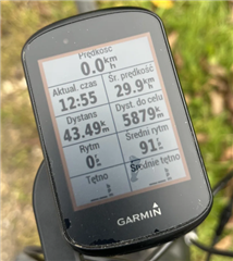
Two rides without info about turns, graphic or audio. GPX made in komoot, dropped to connect. Got second edge 530 and there it works. Look at the distance left.... 5879km, should be ~30km Whats the problem?


