This discussion has been locked.
You can no longer post new replies to this discussion. If you have a question you can start a new discussion

Edge triples altitude in routes

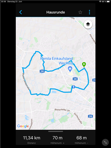
My Edge 530 significantly overestimates the elevation of routes. Here comes an example:

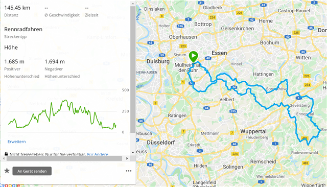
Route in Garmin Connect - elevation 1685 m (realistic):

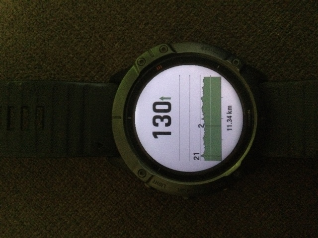
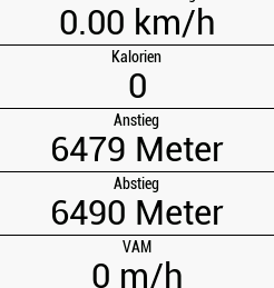
Elevation calculated by Edge 530 - 6479 m (much too high)

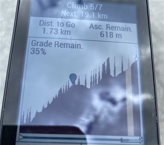
Height seems to be correct on the Edge 530 (max. 380 m), but overestimated elevation causes "too red" climbs:

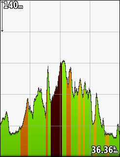
Cycling maps north-east and south-west, digital elevation map, and basemap are active:

Any idea about the reason of this miscalculation?

Feedback is highly appreciated. Thanks!

  • Btw: I planned a course in gcm:

    If I send it via gcm to my edge830, I get:

    if I send it via gcm to my F6xPS, I get

  • That course is likely too flat to see the problem. The more climbing a course has the easier it is to see the problem. 

  • Hi there,

    exactly the same problem here on my side. 

    The ascent displayed on Garmin connect is pretty accurate - then the Edge is grossly blowing up the ascent. I do have the same sawtooth patterns on the climb-profile. See picture. 

    Kind regardss
    Bernhard

  • Well, maybe you just have the steppest climb in the world on your route ;).

    They really need to correct this because climbpro is garbage because of that - there's not other use for it than checking the suffering distance left for the climb currently Disappointed

  • I wanted to show something else:

    I have done this course very often with different Garmin devices without using a course. The activity files are showing an elevation gain for this activity of about  only 14-16 meters (I live almost on sea level here). If I create exactly this course in gcm, I get an elevation gain of 70 meters for that course. If I transfer it to my Edge, I get an elevation gain of 162 meters, if I transfer it to may F6xPS, I get an elevation gain of 130 meters. So I think, the used elevation in gcm for creating a course must be faulty (for some areas) and why are the devices after course transfer via gcm showing different values? 

  • Here is a work-around to transfer a course created on Garmin Connect to your Edge with correct elevation:

    Create the course on the Garmin Connect Website.

    Export / save the course as GPX file on your PC.

    Convert the course to a FIT file, for example with this site.

    Copy the FIT file into the "NewFiles" folder of the Edge.

    Then, the course is available on the Edge. To my experience, the total elevation is slightly under-estimated (approx. 20%), and the elevations of the detected climbs seems to be correct.

    Hopefully Garmin fixes the issue quite soon. I don't understand why Garmin (obviously) modified the way to create the FIT files via Garmin Connect website since it worked well previously. Maybe the increased amount of course points in the FIT files (that's what I understood to be the change) was intended to support fast route calculation on the Edge...?

  • You don't need to convert GPX course files to FIT files.  Edge units understand GPX files. You just need to put the GPX in the new files folder.

  • I've experienced this issue as well last week doing some serious MTB tours in Germany, climbs that should be e.g 300hm trippled to 950hm. EXACT same GPX file loaded onto an Edge 1030 did not have same issue, so the problem is device specific to the Edge 530 / 830.

    Trips were built based on original GPX files mapping out the area and then edited in Garmin BaseCamp, which did not show any odd elevation data nor any spikes. File was also tested in RideWithGPS which also had normal elevation data and no spikes. So I suspect spikes are generated on the device itself and not about noise in the GPX file.

    An additional observation: If after the ride I then selected to compete against existing activity and selecting the ride over these hills, the new ClimbPro data was normal & correct, these showed up now with expected elevation data, so data already on the device doesn't get the same noise.

    I did see aweatherall confirmation further up that Garmin has found the issue and is working to fix it. I hope it will be quick, because last week was my first use of ClimbPro, was looking much forward to it to help on the steep MTB climbs, and first panicked a bit thinking some of the climbs were crazy high, then finding the feature was completely useless (at the time). Hope to get a much better experience in the future - the concept itself seeems great to use for long climbs.

  • There is no issue if you use a GPX route file directly from a route planner like RIdeWithGPS, Komoot, Strava.  The problem occurs if you use the system to sync the ride from the route planner to your Garmin through Garmin Connect.  Just copy the GPX file from RideWithGPS directly to the newfiles folder on your Garmin and the elevation data will be OK.