This discussion has been locked.
You can no longer post new replies to this discussion. If you have a question you can start a new discussion

Edge triples altitude in routes

My Edge 530 significantly overestimates the elevation of routes. Here comes an example:

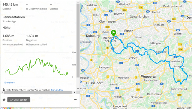
Route in Garmin Connect - elevation 1685 m (realistic):
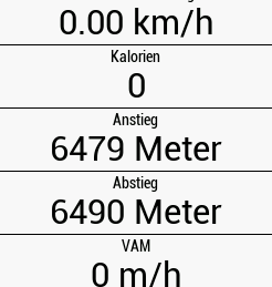
Elevation calculated by Edge 530 - 6479 m (much too high)
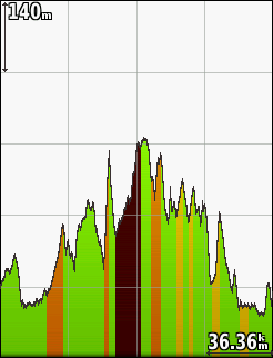
Height seems to be correct on the Edge 530 (max. 380 m), but overestimated elevation causes "too red" climbs:
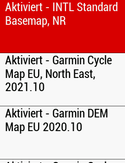
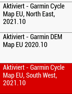
Cycling maps north-east and south-west, digital elevation map, and basemap are active:
Any idea about the reason of this miscalculation?

Feedback is highly appreciated. Thanks!

  • I don't think the google share is set to public.

  • I sent the course to my Edge 530 and hit the same problem. I will raise a ticket with Garmin.

  • I set the Google Drive folder now to public, although I think it's no more required since you replicated the issue.

    Thanks for raising the ticket. Do you know how I can get feedback from Garmin? Do you have a ticket number and contact data, or would you be so kind to report here when you received feedback from Garmin? Thanks.

  • I don't have a number yet. It is a 3 day weekend here in the US so I will not hear anything back until Tuesday. I will post any update I get to the this thread. 

  • I'm seeing the same problem too.  I don't ever look at the course summary on my Edge, but I had noticed recently that when following courses, the altitude page and ClimbPro pages both had altitude profiles that look like saw teeth.  The overall profile looks about OK, but there are loads of small ups & downs.  This could well explain why the Edge thinks there is so much more altitude gain than reality

  • I have very similiar issue, I already posted it on Reddit(Link here). It seems to be related to same thing. For whatever reason Garmin creates 'micro' spikes along the router which cause altitude overstimation. It is visible in climbpro profiles in particular - please refer to this screenshot from mine climbpro. This hill had starting altitude of 245m and ending of 265. Garmin estimated altitude gain of 150m! Profiles has a lot of these 'spikes' and before it was just a smooth line of a climb. Something's definitely wrong. I marked some example spikes, but there tens of them as you can see. The road was smooth not going uphill/downhill while still climbing uphill. I guess if they accumulate over the longer course then they inflate altitude by a lot. My climbpro is pretty much useless due to that.

  • Same for my profiles on climbpro. I think it estimates altitude gain for these micro spikes which appear on the profile which in the end cause that altitute is balooned for climbpro. In some of my cases it overestimated it from 2 times to 8...(it made 150m altitude gain from real 20m of alt gain...)

  • Just chiming in here to confirm that I have the same particularly annoying problem. The troughs and peaks displayed on my unit (Edge 830) elevation graph are roughly what is predicted by the elevation graphs of Garmin Connect and third party (Komoot in my case) route creators, which is fine. Instead, my issue is the same as the OP: the summary screen on the unit displays ludicrously high total ascent and descent values, which is likely due to the sharp jagged edges of the elevation profile generated on the device making sharp inclines and declines where there aren't any. This affects affects the following:

    • Total ascent/descent is inflated.
    • ClimbPro is rendered useless. It may tell me there is a long climb coming up when the track is clearly flat, and vice versa.
    • The 'remaining ascent' number is unreliable.
    • The severity of climbs is miscalculated. A supposed 8% could be a 2% that is distorted by the bizarre jagged line on the elevation profile.

    For such an expensive device, this is obviously unacceptable. Only just bought this thing, haven't even been for a ride, and already I'm facing issues and having to be mindful of getting a refund.

    While I think on that option, a workaround I am going to use is Garmin Connect's course point feature; I will refer to Komoot's elevation profile and set course points called "7% start 500m" and "Climb 0.5mile" (for example) for the standout climbs. These points should pop-up on the screen while I ride and I will know what climbs I am facing. If I found out that this feature doesn't work either I'm gonna go ape and literally throw the device back to where I bought it.

  • Garmin have found the issue and working to release a fix