This discussion has been locked.
You can no longer post new replies to this discussion. If you have a question you can start a new discussion

Has the navigating by Course Points been removed?

I replaced my Edge from 520 to 530 (for ASIA ver 2.90).

I think that navigating function does not use Course Points data. Navigation is based on each map data isn't it?
I found this behavior in Audax ride.

Edge 530 acts following when using Turn By Turn navigation with TCX file which includes cue sheet data by Ride with GPS.
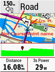
- Approaching a turning point when Guide Text on Map screen displays road name which seems registered in internal map.
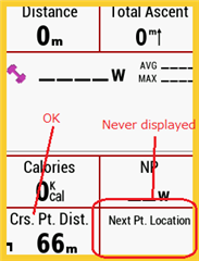
- Data Fields "Next Pt. Location" displays same text.
- A name of Course Point is only displayed on pop-up when just arriving a location of a Course Point.

Does 530 have navigation by Course Points like 520?
Current navigation does not fit to my Audax ride.

  • The TCX course point "navigation" was the most useful feature on the 520, it was introduced in FW 12.1 and was brilliant , it allowed me to turn off the internal navigation so the course started immediately without any long "calculation" wait but still gave next turn details including distance countdown in the map guide text and "next course pt" field and the bottom of screen "pop up" about 100m before turn all based only on the route generated or custom cue entries ("course points"), absolutely perfect for Audax and most other purposes. Why would anyone (Garmin) remove such a useful feature, if it has gone I won't be "upgrading" to a 530

  • It still supports this feature. The question is what site are you using to generate the course file. If you create a course in Garmin Connect and download it directly to the Edge then Garmin Connect only adds course points to the file if the target device does not have on-board maps and routing support.

    If you use a third party site such as RWGPS you will set get your course points and the Edge will process them provided you export them.

  • "Does 530 have navigation by Course Points like 520?"

    Yes.

    The units that use maps provide the option to use course points (other than the Touring).

    This has been the case starting with the 800.

    The Touring didn't support course points. I don't know whether the Explore units do.

    Course points are supported by the units (500/510/520) that don't use maps.

    The 520 displays maps but doesn't use them.

    The 520+ and 530 use maps (they can calculate routes on the device).

  • Thanks, that is a relief, best feature and yes the Audax (Australia) club has a RWGPS club account and all the routes are in a club library, probably thousands of routes. The routes for club rides are mandatory so I don't want the 530 deciding it knows a better route and the ride organisers go to a lot of trouble to provide meaningful cue entries which are reflected in the course points. So the answer for the OP (NOMI) would be no it is still there but use RWGPS or other planning site rather than Garmin Connect

  • Garmin Connect tries to be "smart" about the device. RWGPS just produces a file (it doesn't know what the device is).

    There are two types of navigation:

    1- track following and course points.

    2- fancier navigation that uses information on the installed maps.

    The 520+, 530, 8xx, ,1xxx can do both at the same time or either separately.

    The 500, 510, 520 can only do the first. The 520 displays maps but the installed maps don't have much detail.

    The Touring could only do the second. I'm not sure about the Explores.

    You'd disable "turn guidance" and "recalculate" and enable "course points".

  • Yes, it is useful feature for many rides. I'm glad you think the same way. It was only a short time that I was pleased with the new Edge.

    I couldn't navigate at least as much as 520. I'm looking for a way to navigate as I want.

  • Thank you for your replying.

    The following is an excerpt from the TCX by Ride with GPS. (Location is Japan)

    <CoursePoint>
    <Name>S/L</Name>
    <Time>2019-09-12T03:06:41Z</Time>
    <Position>
    <LatitudeDegrees>35.63811</LatitudeDegrees>
    <LongitudeDegrees>139.49164</LongitudeDegrees>
    </Position>
    <PointType>Left</PointType>
    <Notes>S/L</Notes>
    </CoursePoint>

    The TCX seems to include correct Course Points data. My 520 navigated by Course Points as before when using the same TCX as 530.

    If only select a map it has no routing support, will 530 navigate by Course Points without calculation? Or, is it possible to request a setting item that gives priority to navigate by Course Points? (like 520)

    The Data Field "Crs. Pt. Dist" works in the same as 520 now. I want guidance text on the map screen and The Data Field "Next Pt. Location" to display next Course Point name as bparker52 said at the beginning.

    Course Point infoMap screen in navigation

  • TCX and FIT files can contain course points. (GPX can't).

    The big white arrows are from "turn guidance".

    The arrow at the top left of the second screen is from turn guidance. So is the label at the top right.

    "Next Pt. Location" displays the next "turn guidance" label.

    I don't think there's a way of displaying the next "course point" name. At least, that's how it appears to work on the 1030 (I don't have a 530 but the units mostly work the same).

    I think I recall reading posts here talking about not having the course point name display on the newer units.

    (The 800 lets you display the course point name as a data item.)

  • As dpawlyk says it seems like you have the "turn guidance" on (thus get the big white arrows) and in this mode perhaps the map next turn name has priority over the "course point" name. Turn off the "Turn Guidence" and see if you get the TCX course point name in the top of map "guide text" as per the 520 . I have never got the "Next location" field to display anything on the 520 so assume it only comes from a routable map on a device supporting the internal navigation


    (520 screen shots, "turn guidance" off but TCX course loaded with custom cue entries, the "guide text" distance counts down, as does CRS PT Dist and the bottom of screen "popup" appears about 100m from course point location, with warning tone, also counts down and disappears when location is reached.)

  • Oh Buddha.

    Thank you for your investigation.
    Certainly 520 could not have a detailed map to navigate. I think too that the navigation of 530 is similar to 1030.

    As you said, I could not display the course point name. If this older feature doesn't come back, I might let go of my 530.