This discussion has been locked.
You can no longer post new replies to this discussion. If you have a question you can start a new discussion

Purple Route Obscures Critical Navigation Detail

Hi,

This topic has various names and locked threads over the years, mostly due to personal preference.

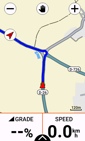
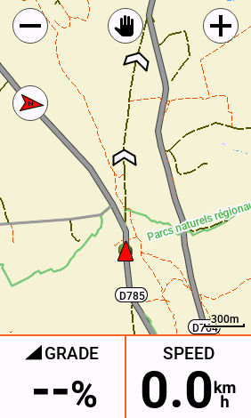
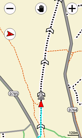
But I have found when off-road and bikepacking, following routes in unfamiliar terrain that not being able to see the underlying topographic detail like if I should be on a road, track or path is a critical omission in navigation.

I already have to have a profile where segments and climbs are turned off (why oh why on an out-and-back route where the > direction arrow clearly knows which way I am going does the ggeen/yellow category climb overlay obscure my route when I am hading *downhill* !) as these cover up even more detail.

But what is needed is ideally the ability to make the route semi-transparent to see if the turn ahead is an obvious gravel road or obscure path (or at least make the track thin so I can see road's wider than the route).

The transparency (first two-bytes in the #hexcolour) for the style has no effect still and I havent been able to get bg_width or fg_width to apply either.

Again, I think this is not a colour preference thing but a critical feature for route-following navigation.

 Cris

example:

<style field="MPM_ACTV_CRS_CLR" scale="0.5" border="0.1"><color><primary day="#ffff0000" night="#00f8ccf8"/><secondary day="#ff000000" night="#fff8f8f8"/></color></style>

Previous posts:
https://forums.garmin.com/sports-fitness/cycling/f/edge-1040-series/366837/route-color---change-to-ffff00ff

https://forums.garmin.com/sports-fitness/cycling/f/edge-530/290989/how-to-make-course-line-easier-to-see?pifragment-1290=8#pifragment-1290=1

https://forums.garmin.com/outdoor-recreation/outdoor-recreation/f/fenix-6-series/204247/how-to-change-the-colour-of-navigation-course-follow-line-with-your-own-map-theme#pifragment-464=4&pifragment-1292=6

  • I have played with the MapTheme files a lot but have lost enthusiasm as Garmin's direction with this most useful feature is shown by support for  it being dropped for the 1050, I expect they may do the same for x40 devices, support has always been patchy and inconsistent.

    Scale & Border have never worked on Edge devices and while the bg_width & fg_width appear for a small subset of elements in the Popularity High Vis Maptheme I have never got them to do anything. There is subtle (and probably unintended) Maptheme support changes from version to version so I sometimes have another play in the hope that something useful has changed. The last such change was in the 24.xx version was for support for "MPM_RTE_ARRW_CLR" & "MPM_RTE_ARRW_OTLN_CLR" changing the base color and outline color of the "MPM_ACTV_CRS_CLR" chevrons, including making both transparent if you want, ie removing the chevrons which does improve the visibility of route rendering on the map. (for the second screenshot I have also made the virtual partner transparent, routes blue rather than magenta .

    The standard route line has ugly thick black borders (secondary) , have you tried making them transparent and the rest (primary) semi transparent ie say first two digits of the color code to hex 80 ? (I have not tried this myself, maybe later if I get more enthusiastic )

    PS Forum prevents me from inserting the XML code!), says "You are blocked"  !!!


  • Thanks @L.Rouge - I think you are the world master in experience in trying these things!

    >> The standard route line has ugly thick black borders (secondary) , have you tried making them transparent and the rest (primary) semi transparent ie say first two digits of the color code to hex 80 ? (I have not tried this myself, maybe later if I get more enthusiastic )

    When I set the transparency to values like 22 I was getting a reddish line, hard to tell but panning across different features and I'm sure it was not transparent - just looked like a fallback colour.  When I tied 00 (I thought maybe make the route completely transparent and rely on the chevrons for the direction, ha!) the route line still showed though.  I'd be interested if you get the same results if you feel enthusiastic :-)

  • as Garmin's direction with this most useful feature is shown by support for  it being dropped for the 1050, I expect they may do the same for x40 devices, support has always been patchy and inconsistent.

    Garmin doesn’t really want people to do this. It’s not supported at all. It just happens to be something people have access to that sort of does some useful stuff. You just have to live with how it works.

  • interested if you get the same results if you feel enthusiastic :-)

    No mine seemed to do what I think you want?

    Only change to the maptheme was to make the route ("MPM_ACTV_CRS_CLR") transparent, ie primary and secondary "#00000000"

     No Course/Route is displayed BUT the chevrons appear on the roads/tracks that would otherwise have the course/route. NOTE that I did not use "Turn Guidance" as this would have overlayed the "calculated" route.

    I also did not have the "Unpaved Roads" overlay enabled as this would have replaced the road/track symbols with the generic "unpaved" one

    You could still change the color of the chevrons to make them standout more.


  • PS I am running beta 26.12 but I doubt that makes any difference, the maps above are from Europe - West

  • With the Unpaved Overlay enabled. Looking at these, you know I think I like them like this without the purple / magenta / my blue course / route , it might grow on me?


  • On an unrelated note, I haven't done a lot of Garmin rides in recent months, have been seduced by FulGav and enjoying it but it seems the 2024.20 Map update has changed the road colors again, pre 2024 the Europe roads were a mix of colors related to importance, then in 2024.10 they became mostly blue and grey but now seem to be all grey and with a lot more tracks / footways / trails etc even at higher zoom out levels?

  • Excellent - I had not tried completely transparent #00000000, only partial with a colour. if I can made the primary 100% clear and have two purple/whatever tramlines as secondary colours this will show the route and what’s underneath… back to the editor. I wonder if I should try the same for hill climb categories and segments also… one thing at a time!

  • I wonder if I should try the same for hill climb categories and segments also

    Like the "Turn Guidance" calculated route the climb & segment ones are controlled programmatically and not via the MapTheme although I have never found a comprehensive catalogue of all the possible MapTheme elements, where Maptheme elements are missing there seems to be a default color for all elements. Good Luck with it, I might see how I go with just the chevrons without a colored route.

  • You just have to live with how it works

    Yes, pretty much the garmin philosophy but they could, at minimal cost, make it so much more useful for customers. I am using my garmins less & less, I waste too much time on playing with garmins rather than just riding, all I wanted for christmas was a bigger map cursor, I won't be buying a 1050, oh well.