This discussion has been locked.
You can no longer post new replies to this discussion. If you have a question you can start a new discussion

Mtb trails drawn twice on map

I just started using my Edge 1040 for trail navigation (not realizing until now that it had that feature!). It has potential to be great, but the map is almost unintelligible because the same trails seems to be drawn twice, on top of themselves, but with slightly different lines. This is manageable (albeit annoying) when following a single trail segment, but confusing to the point of being useless at intersections.

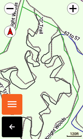
For example, look at this screenshot:

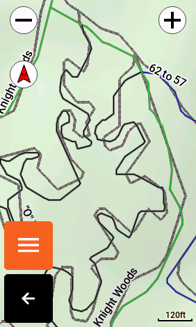
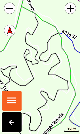
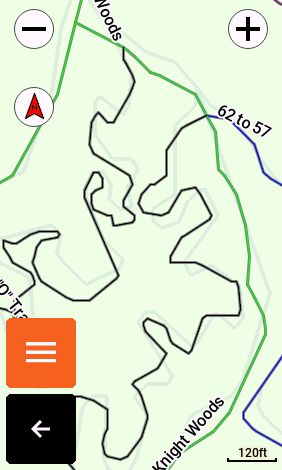
This map is actually much clearer on the computer than on the Edge itself, but you can still see the rat's nest of lines for what is a relatively simple trail system IRL.Following the black, windy part is pretty obvious when riding; it's weird looking, but it's a single loop so you basically know where you are.

When you get to the intersection in the upper-right by that "62 to 57" label, though, which way do you go? How many trail actually intersect there?

I've been riding in new-to-me areas for the past month, and have made myriad wrong turns because the maps are so bad. To work around the problem, I've set the GPS to "Best Accuracy: Multi-GNSS Multi-Band" (at noticeable expense of battery life) and resigned to just riding a couple hundred yards at each intersection to see where my blue history line goes. When it's headed in the wrong direction, I turn around and guess again at the last intersection until I get it right.

My question is: Is there some way to turn off the "extra" set of trail lines so I can interpret the map more easily, especially at intersections?

There seems to be a high-res color-coded version of the trails, and a low-res same-color version. I think the former is probably TrailForks (after reading a blog post on their website about their cartographic standards for Garmin devices) and the latter are... baked in to the basemap? Overlaid by default? I don't know. Ideally, I'd like to keep the better copy of the trail lines - but I'd settle for the worse ones if that's what it takes to see a single line for each trail.

For reference, this double-line issue afflicts the map everywhere I've ridden in my area since I discovered the trail maps / navigation feature a month ago. So, I don't think it's just a quirk of just one trail system.

Thanks in advance for your help.

  • I believe its because the base Topomap which is derived from OSM data also includes the trails (and why wouldn't/shouldn't they).

    If you look at the Trailforks map for the area and add the OpenStreetMap Basemap to you will see the two trails drawn in a similar way in which the Garmin is doing.

    https://www.trailforks.com/trails/62-to-57/

    Bit of a mess.  Bit of an argument between TrailForks and the base OSM data as to who is authoritative.  Customer loses out.  Thanks.

    If you disable the Trailforks map or the Topomap it will sort the problem but you will lose functionality either way.  Disabling the Topo map will probably result in the the more drastic impact to the functionality of the device.

    Regards

  • Ah, that makes sense. Thank you for explaining this to me (and for finding my same trail for your Trailforks example!). I still don't completely understand how the various map layers work on this device, but I learned a bunch more from reading you reply and playing with my Edge a bit more.

    In the menus under Activity Profiles > [profile] > Navigation > Map...

    I had been laying with the ...Appearance > Map Theme settings. All three options (Classic, High Contrast, Mountain Biking) manifested the double-line problem, so I thought I was just stuck with it.

    After reading your post, though, I revisited the ...Map Information menu. I browsed it briefly yesterday, but thought it was just a list of maps. I didn't realize you could enable/disable them. By toggling the Trailforks 2022.10 and Garmin Cycle Map NA, US 2022.20 I could make one set of trail lines appear and the other disappear. From testing that, I understand now what you mean by:

    Disabling the Topo map will probably result in the the more drastic impact to the functionality

    While the Trailforks map seems to contain a single layer that is just off-road trails, the Garmin Cycle Map map seems to have everything else - roads, trails, park boundaries, etc. Even though the Trailforks trail data is superior (at least in my area) it's not practical to just have those trail lines floating on a blank background with no context.

    I did re-read an article on the Trailforks website that discusses their custom basemaps for Garmin devices. Unfortunately, I don't have a Trailforks membership so I can't see what their Garmin-specific maps look like, but I'll probably buy one just to test it out. Assuming that the Trailforks maps for Garmin don't have the double-line problem, it seems like I have two potential solutions:

    1. Disable the exisiting Trailforks 2022.10 map on my Edge and settle for the coarser, uglier built-in trail lines

    2. Get a Trailforks subscription, load their custom basemap to my Edge, and use it in place of the built-in Garmin map (hopefully it's the same Trailforks Topo style in the link you posted above - it's so clean and readable!)

    One of these will certainly work from a functional perspective. I do wish we had more control over the cartography in general, though. I've had this Edge since last summer, and its content and routing features are incredible - far surpassed my expectations. But, the maps are functionally (and aesthetically, IMHO) poor. Most of my experience so far has been for road riding, and I find those maps equally difficult to read as the trail maps unless I really take my eyes off the road and focus on what the miasma of symbols is telling me.

    By coincidence, my day job is GIS, so I had the notion of creating my own basemap. I did some brief reading with my morning coffee today, but it appears nontrivial to make one's own maps in Garmin .img format. I may do it someday, but it ranks low on my priority list at the moment.

    I do have one more technical question, if you happen to know:

    Q: Is each "theme" (e.g. road, trail, POI, boundary) stored as it's own layer in the .img format, such that it can be manipulated individually, or are they all baked into one pre-rendered image?

    I ask because the ...Map Appearance menu area gives several options that let us customize the visibility and style of some map elements (e.g. Map Theme, Map Detail, and Advanced submenus). If, for example, I can change the look of the same trails/roads/etc. by switching between the Classic, High Contrast, and Mountain Biking map styles, one of two things must be happening: 1) different themes are stored in their own layers, or 2) there's pre-rendered basemaps for each of these different map styles.

    I'm guessing it's probably #1, because we have relatively fine-grained control with things like the ...Appearance > Map Detail setting, and the ...Appearance > Advanced > Zoom Levels setting. I think it'd be impractical to create pre-rendered maps for every combination of these variables (e.g. map maintenance, storage space). So, it seems that there must be some sort of layer-level control over content in these maps, even if Garmin doesn't fully expose it to us.

    Back to the point - if we can customize the text size and zoom levels and contours and all that stuff, it'd be nice to also be able to toggle off the lower-quality trail lines that come with the basemap and display the better Trailforks lines instead.

    The prior tangent notwithstanding, I have at least one, and possibly two, solutions to the original problem that will work well enough. Thank you again for taking the time to write!

  • Or you might be able to modify the trail line color, have a look at this discussion about modifying the MapTheme XML, have a look at the Pinns Maptheme editor mentioned on page 4 or 5 as that author has a knowledge of the format. One problem is that Garmin does not publish a list of the possible XML elements and options so we are a bit in the dark regarding what is available. There seems to be a built in value in the Garmin software for the various elements and the values in the Maptheme files override these, good luck

    forums.garmin.com/.../1406484

  • Oh no! I just spent an hour writing a response and the bloody forum won't let me post it:

    Maybe it's too big; I'm going to try to post it in sections. Standby...

  • Eureka! This is what I was seeking - both specifically for this issue, and generally to customize the cartography.

    Thank you for letting me know about that thread. You guys have had a great discussion over there, with enough detail to get me started on what will certainly become endless hours of infinitesimal tweaking of my maps Slight smile

    I'll summarize the relevant parts of that thread as they pertain to this double-line issue, in case anyone reading this doesn't want to go down the rabbit hole of theme customization. You'll still need to be handy with a computer, though, so if the comments below don't "just make sense", it's probably best not to mess with things until you learn a bit of computing background.

    • The map symbology (e.g. colors) is controlled by theme files. These are in XML format, and located in the following folder when you connect the Edge 1040 to your computer (I'm using Windows 10): \Garmin\MAPTHEMES
    • The built-in themes (e.g. Classic, High Contrast, Mountain Biking) get overwritten when you restart your device. So you need to copy one of the default files to a new name before customizing it. Once customized, your new theme will show up along side the built-in ones in Activity Profiles > [profile] > Navigation > Map > Appearance > Map Theme.
    • The theme files override the default symbology. So, you only need to include the <style> elements for the things you care to customize. Note, however, that something like the Mountain Biking theme already customizes a lot compared to the defaults. So, I copied that file (Mountain.kmtf) as a starting point and further customized it for my needs.
    • You can only customize some things, like color. Others, like the line width, or whether a line is solid or dashed, are not customizable (that we know of). Also, the meaning of "primary" and "secondary" differ among the line styles. For example, for a solid line, primary may be the center color and secondary is the edge color. But, for a dashed line, the primary and secondary values might control the alternating dash colors.
    • The color specifications are in hex format like #AARRGGBB, where:
      • AA: Alpha channel (transparency). FF is fully opaque, and 00 is fully transparent.
      • RR: Red
      • GG: Green
      • BB: Blue
    • None of this is documented (AFAIK) so you need to experiment.

    What does this mean for the double-line issue?

    • The style of the basemap trail lines is named MPM_TRAIL_CLR
    • This is a dashed line, and the "primary" and "secondary" values are the colors of the alternating dashes.
    • By making the basemap trail lines transparent, or otherwise deemphasizing them, I was able to keep the Trailforks lines visible as my primary trail line and keep the rest of the basemap features (e.g. roads, rivers, park boundary) for context.

    [CONTINUED]

  • [CONTINUED]

    Here's a few examples of the basemap + Trailforks, with various basemap trail customizations. Changes from the default XML are highlighted in red:

    Mountain Biking Default

    This is the original, messy pile of basemap and Trailforks lines that comes out-of-the-box.

    <style field="MPM_TRAIL_CLR">
        <color>
            <primary day="#ff808080"
                     night="#ffc0c0c0"/>
            <secondary day="#ff805858"
                       night="#ff805858"/>
        </color>
    </style>


    Fully Transparent Basemap Trails

    I changed the alpha channel from FF to 00 for all colors (primary/secondary, day/night). Basemap trails are gone, and the Trailforks trails remain.

    <style field="MPM_TRAIL_CLR">
        <color>
            <primary day="#00808080"
                 night="#00c0c0c0"/>
            <secondary day="#00805858"
                   night="#00805858"/>
        </color>
    </style>

    White Basemap Trails

    I found a few instances where the basemap showed a trail that Trailforks did not. I don't know which is correct in those cases, but thought it might be handy to show the basemap trails as white lines while I'm riding. These blend in to the background well, and don't obstruct my quick visual interpretation of the Trailforks trails.

    <style field="MPM_TRAIL_CLR">
        <color>
            <primary day="#ffffffff"
                 night="#ffffffff"/>
            <secondary day="#ffffffff"
                   night="#ffffffff"/>
        </color>
    </style>

    Light Gray Basemap Trails

    The white basemap trails may blend in to the background a little too well. So, I tried a variation with a light gray color (with the tiniest hint of green). After some experimentation, this shade worked well for my eyes to blend into the background, but still also be visible enough to see a "missing" trail peeking out from underneath the Trailforks layer.

    <style field="MPM_TRAIL_CLR">
        <color>
            <primary day="#ffddeedd"
                 night="#ffddeedd"/>
            <secondary day="#ffddeedd"
                   night="#ffddeedd"/>
        </color>
    </style>

    I have all three saved as separate themes on my Edge, so I'll experiment with them next time I hit the trail, in the sunlight and shadows, with my sunglasses on, with my head jittering from the trail surface, etc. I've been doing all of this from my desk so far, so I don't know what will work best outdoors.

    Lastly, here's a slightly zoomed-out screenshot of the transparent theme. I'm just including this to show that everything from the basemap (e.g. roads) is still there, along with the Trailforks trails, but without the basemap trails:

    This theme customization process is laborious, not least because you need to connect / disconnect the Edge from the computer each time you want to see the effects of your changes. It takes my Edge like a minute total to go through this cycle. Plus, once the Edge interface is back, you need to make a million clicks to get back to the map view that you want to see. It's not for the faint of heart - but it is worth it to be able to see a better map. At least for me.

    Thank you, @L.Rouge for your comments here, and for your copious information on the other thread. Both of the posts so far have provided me with valuable feedback, though the theme customization is a closer match to what I was seeking. So, I'm going to mark your reply as the answer.

    Happy trails all!

  • I am glad you found it helpful and thanks for your detailed writeup so others can make use of the knowledge you gained. I don't do trails (not good enough) but it is a surprise that Garmins offerings here are so confusing, your solution would be worthwhile. I use the MapTheme for simplifying the maps, I do long distance and don't really need ground cover details, I just need roads and maybe towns, rivers good too. I have changed the color of most of the ground cover (forests, etc) to be the same as the base ground but I might also see if making them transparent is better. Garmin stubbornly refuses to make the position symbol bigger, I have it pink or blue or orange but would really like it bigger too, nice also if they supported the width / scale modifier so roads / routes could be slightly wider.. Thanks again  & happy trailing

  • Thanks for the useful thread that expands on @L.Rouge 's explanations.
    I think it would be good if you also post where the topic is originally covered and might get lost here.
    I saved the link to the following thread so I can always find the explanations of Mapthemes:

    forums.garmin.com/.../how-to-make-course-line-easier-to-see

    (or even better: someone might open a new thread „Manipulating Mapthemes“ with all so far kown possibilities…)

  • , done. Good idea, and thanks for the suggestion.