This discussion has been locked.
You can no longer post new replies to this discussion. If you have a question you can start a new discussion

Mountain Bike maps and GPS accuracy

Former Member
Former Member

None of the major reviews (nor the Garmin website) appear to actually show what the "MTB Navigation" menu includes.  It sounds like the Trailforks basemap layer might not be included, but would support the app (which I don't think is really good as I don't want to load saved courses; I want to see the available trails). 

Can anyone with a device in hand comment on what type of MTB trail data is included and how it works? 

Will I need to subscribe to Trailforks Pro and download their version of the basemaps for Garmin devices in order to get color coded trail layouts?  I try not to navigate on non-stock maps as it leads to a whole series of issues on older Garmin Edge devices. 

--

Regarding SPEED SENSORS.   I always run them on mountain bikes with everything up to the Edge 830, otherwise total distance is cut way short on singletrack.  Has anyone been able to test and confirm if I can ditch the speed sensors for mountain biking on the 1040? 

Top Replies

All Replies

  • 10 to 20%?  I've never seen more than 3%.  And my main answer has been that with the 1040, I'm off by under 1%, where as it was often 2 to 2.5% on my 1030+.

    I'm also pointing out that the speed sensor is now no better at reliable distance for MTB than GPS, and has it's own issues with accuracy.

    If there's a 10 to 20% discrepancy, how do you know your speed sensor is accurate?

  • Former Member
    0 Former Member over 2 years ago

    My results were similar.  If I go to any single track within my state and look at the posted distance on maps or based on using my wheel sensor that was calibrated on the road with similar tire pressure...

    Once I remove the wheel sensor and record the ride based on GPS/glonass on x30 series edge, it's fine on road and gravel but can be 10 to 20% lower distance on trails depending on the trail.  I generally match up very close to the posted distance if I use a wheel sensor.

    If it were due to GPS inaccuracy I would have expected it to not always be low rather than a fluctuation of high and low.  I think that's why a lot of people, including myself, had always assumed that the total distance at the end of ride is going based off the points.  (Just showing some perspective on why others might have thought this).

    It will be interesting once some of us can actually test with the 1030

    I should add that The Garmin edge x30 does not factor in distance for sections where you go under a certain speed which I forget the number.  I found this out after using the edge to kayak and overshooting the exit ramp by several miles before having to drag the kayak upstream.  There was a forum in here somewhere that went into detail why that is?.  This of course was without a wheel sensor, but I don't know whether or not that matters.  So this could have something to do with the slow sections without a wheel sensor not being added to total distance, although I wouldn't think I'm going that slow on some of the flatter twisty trails lol. So one thing to factor into this whole mess is that the garment edge without a wheel sensor even though displaying speed may not add very slow moving sections in the total distance . We will get this figured out!

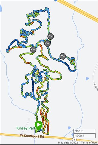
  • Your winding MTB trails are obviously less winding than my local trails. Slight smile  The screenshot below is an example of my local trails systems.  Compact areas with a lot of twisty-turny trails.  This ride was 9.8 miles for reference.

    If you properly calibrate your wheel speed sensor, I don't know why you wouldn't trust it.  Even if your calibration is off by 2 inches on the circumference of the tire that's still only 2%.  

  • Former Member
    0 Former Member over 2 years ago

    For those who are curious, the 1040 is the same as the 530/830/1030+  for maps.  

    The basemap is OSM and there is an additional transparent Trailforks basemap for MTB profiles which is color coded.  

    There is also the Trailforks app, but that is just for pulling in routes.  The Trailforks basemap (different than the CIQ app) is a useful overlay that houses all mountain bike trails.  

    -Regarding GPS accuracy and total distance logged, I'll try to test this week sometime.