This discussion has been locked.
You can no longer post new replies to this discussion. If you have a question you can start a new discussion

Problem with Altitude data. Barometric sensor issues

This is to show the real issue with barometric sensor within the Garmin Edge 1030 plus.

Has been discussed in several threads, also linked to the Gradient data issue. This topic is related to Elevation data itself.

This photos were taked in a ride before the climb to a mountain and at the top.

1. Photo doing calibration altitude at 1200m, both the Road Signal (altitud = altitude in english) and the Edge.
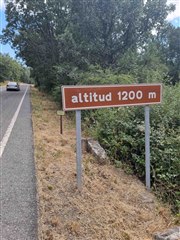
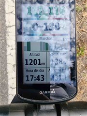
2. Photos taken at the top of the climb:

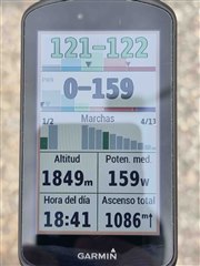
Yo can see that even calibrating it at 1.200m (I do not know why I set 1.200m and a second later shows 1.201m, but 1 meter is fine for me), at the top, 1 hour later there is a difference is 51m which is huge (Garmin 1.849m, real 1.880m). I do not have the Garmin Edge 1030 yet, but I can ensure you is much more precise, within a range of 1-2 meters, and has been spot on on this matter for 2,5 years with me.

Please Garmin, Solve whatever issue this model have with Altitude.

Top Replies

All Replies

  • meanwhile i found an accurate altitude data for this starting point, it is 696.181m (so not 701m, that is 100% sure)

  • Hi Luko, at the end I did the test with Garmin 935 and with Garmin Edge 1030 plus.

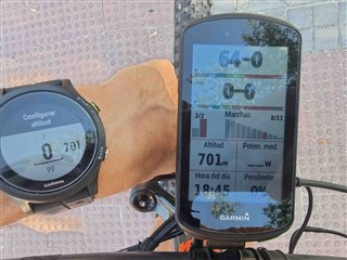
    Regardless the mapa info (the Altitude info is comming from the Spain Geophrapic Institute Topo  -not the Garmin one-, so I will say it should be accurate). Anyway I calibrated both at the same point (701m), so comming back should be at the same altitude.

    This is the result:

    Starting point:

    And this is at the end:

    So, the Garmin 935 is 1 meter difference at the end, and the Garmin Edge 1030 plus is 7 meters, not a big difference, but definitively greater than the Garmin 935.

    So it is not only the delay in data (I wait 30 secs to stabilize Altitude before photo), it is also accuracy.

    Regards,

  • i know that that measurement was coming from spanish topo map but it is inaccurate. (and some devices can recalibrate itself from GPS altitude so an inaccurate starting point can lead to higher difference between 2 barometer devices with different settings)

    just let me show You an example about barometer inaccuracies: both (830 and F3 was calibrated at the startpoint 461m), the 3rd device is a dual-gps band MI8 (it was using only GNSS data for altitude measurement here, a very accurate "semi-professional" device btw)

    so, as You see the barometers in both Garmin devices are hugely off as the reference data and at the end the both Garmin devices showed 469.2m, the MI8 showed 461.240, but You have to always deduct ~1.20m from this because it is in my backpocket and the reference geo datas are reffered to the ground. 

    the highest difference as the picture shows on a pancake flat longer open-air section , the swiss (lidar based, subdecimeter vertical accuracy) geo map shows 398.8m there, the MI8 400.038m (-1.200m so 398.838m), both Garmin units show "much higher", 413m and 411.8m but the full chart compare is much more spectacular.

    So do not pressure yourself about the barometer inaccuracies, these wont be "super" accurate and reliable measurements, just average.

    https://ibb.co/d6LztBC

  • I will try from location you suggested, but this point in the Spain Topo Map  it is 726m, so very near in deed to 725m, and if this altitude is accurate then we should belive the 701m of the same map sould be it so.... Anyway I will start track today from there ;-). I'm just curious to see the results and keep everybody informed. Again Garmin 935 and Edge 1030 plus.

    This would be the more extensive test of the barometric altitude for the Edge 1030 plus to date   :-)

    Regards,