This discussion has been locked.
You can no longer post new replies to this discussion. If you have a question you can start a new discussion

A bug following gpx track

Hi all,

I've a Edge 1030+, version 4.10.
I noted this behaviour, which I find very annoying. Is it common? Is it a bug that will be fixed soon?
I describe here the steps.

When I want to follow an uploaded gpx track, the device needs to "recalculate" the track. I can't see why, since it is a gpx track and I just want to follow it, regardless of the roads on the map. I assume this is to optimize the gpx forcing, when possible, to follow the roads that are on the Edge's map. This is ok (but see next step).

When on a sharp turn on a mountain climb, I see that I am exaclty on the track that Garmin recalculated, but sometimes I am slightly outside the original GXP, which has a finite number of points. Then, the edge says "off track, recalculating" (or something like this).

This happens very often and it is really annoying.

Thank you

Edit: I see my version is old. This is surprising, because my EDGE says that the version is the latest available. I'll update. Does anyone knows wheter this bug was fixed?

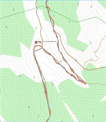
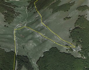
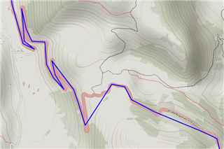
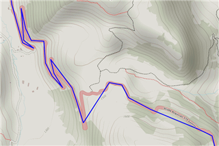
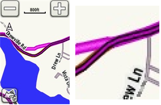
Edit 2: I attach a screenshot illustrating the issue, see my comment few posts below.

Top Replies

All Replies

  • Hi. Then the simplification was due to the import s/w. Ony the blue and brown lines matter.

    Thank you for your help.


    Da_Avezzano_a_Cassino-1.gpx_course.fit.zip

  • Your course fit file out of your Edge contains far too few trackpoints! That explains everything!
    (Probably also the problem with Climbpro - see Alen's answer.)
    The trackpoints are up to 1 km away from each other and have elevation differences of up to 60m.
    The Edge device does not reduce the trackpoints when converting to FIT. The exporting program must have already done that.
    Here's what I would do:
    After you have convinced yourself that the GPX file is complete and correct, copy it into the Edge directory Garmin/NewFiles!
    Then everything will work!


  • That track isn't right. It won't work properly (and be expected to give the result you are seeing).

    I believe the file is being created in \Garmin\NewFiles with fewer (too few) points and the Garmin is just using it as it is.

    That is, your issue is with the original file.

    Where are you getting the file?

    It looks like you might be exporting the file (from whatever) as a "route" file.

    • The Garmin Edges require track files (files with lots of points that accurately trace your intended path).
    • The Garmin Edges don't remove points.

  • I really appreciate your help but I still see the bug.


    If providing a gpx with too few points causes such behaviour, then the device should raise a flag, I think. How can I know that while cycling?

    Also, the 1030+ already reconstructed the gpx to the needed precision ("recalculating").

    What I don't understand is: when I import a gpx, regardless of the precision, and I start the navigation, what am I following?

    If I am following the original gpx, then there is no need to recalculate it

    If I am following the recalculated track, then I was never out of track.


    the issue with climb pro is completely different. The display was stuck to a climb that was not even more in the current track.

    Thanks

  • Where are you getting the course file? (I have no idea why you haven't told us.)

    If providing a gpx with too few points causes such behaviour, then the device should raise a flag, I think. How can I know that while cycling?

    The device works the way it does. Changing the way the device works isn't a practical way of dealing with your issue since it's extremely unlikely Garmin will ever change it.

    You won't know when cycling. The way to deal with it is to use the device properly: use track files rather than route files. Once you are aware of that requirement, it's likely you handle it fine! Lots of other people do and have for years (it's old behavior).

    ===========================

    The behavior makes more sense if one is aware of the history of the devices.

    Originally, these sorts of devices only supported "track following".

    Garmin added the "turn guidance" stuff as an extra feature while preserving the original behavior. Note that the original behavior is still important to have.

    ===========================

    What I don't understand is: when I import a gpx, regardless of the precision, and I start the navigation, what am I following?

    If I am following the original gpx, then there is no need to recalculate it

    If I am following the recalculated track, then I was never out of track.

    • The device works the way it does (not the way you might want it to).
    • "Gpx" refers to the format the data is stored in. Not the data itself. 
    • In this case, your GPX file appears to be a route file (something that has few points).
    • The Edge devices require track files. The track file has to have enough points to trace the turns and curves of your path accurately.
    • Files that have too few points (like your example) will not work properly.
    • The device doesn't recalculate the original track.
    • The Edge devices that use maps have two modes of navigation (they can be used together or separately): 1- track following, 2- "turn guidance".
    • The "off course" warning is based on the loaded track.
    • Since your file has too few points, you were often not on it. The "off course" warnings are completely expected in this case.
  • the issue with climb pro is completely different. The display was stuck to a climb that was not even more in the current track.

    It might be the due to not using a proper track file.

    The elevation profiles used by climbpro for a course are taken from the track.

  • I would like to stress the fact that it was a proper track file, just with few points. I admit the incorrect information: not 2700 points, just 700. I'm very sorry. Still, it is a track file, like thousands I have  Can we please go further?


    The problem is that when you say:

    "The device doesn't recalculate the original track."

    It does. It takes a minute every time.

  • I would like to stress the fact that it was a proper track file, just with few points. I admit the incorrect information: not 2700 points, just 700. I'm very sorry. Still, it is a track file, like thousands I have  Can we please go further?

    The blue line needs to follow the roads.

    It does not follow the roads.

    It does. It takes a minute every time.

    No. It's calculating the secondary track.

    The device is getting the "off course" warning from the primary track and then doing the recalculation of the secondary route.

    The file you are using is bad. Things won't work well with it.

    ============================

    The darker line is the primary route (which needs to be a proper track).

    The lighter line is the secondary route. This is what the "turn guidance" is based on.

    This is from an 800. All the units work the same basic way.

  • It's not bad, it just has a low point density.

    Can you please specify the accurady that Garmin EDGE 1030+ requires to handle a track file correclty?