This discussion has been locked.
You can no longer post new replies to this discussion. If you have a question you can start a new discussion

A bug following gpx track

Hi all,

I've a Edge 1030+, version 4.10.
I noted this behaviour, which I find very annoying. Is it common? Is it a bug that will be fixed soon?
I describe here the steps.

When I want to follow an uploaded gpx track, the device needs to "recalculate" the track. I can't see why, since it is a gpx track and I just want to follow it, regardless of the roads on the map. I assume this is to optimize the gpx forcing, when possible, to follow the roads that are on the Edge's map. This is ok (but see next step).

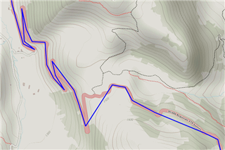
When on a sharp turn on a mountain climb, I see that I am exaclty on the track that Garmin recalculated, but sometimes I am slightly outside the original GXP, which has a finite number of points. Then, the edge says "off track, recalculating" (or something like this).

This happens very often and it is really annoying.

Thank you

Edit: I see my version is old. This is surprising, because my EDGE says that the version is the latest available. I'll update. Does anyone knows wheter this bug was fixed?

Edit 2: I attach a screenshot illustrating the issue, see my comment few posts below.

Top Replies

All Replies

  • It's not bad, it just has a low point density.

    It's bad (for use on the Edges). And obviously so. Look at it.

    It needs to follow the roads much more accurately.

  • Hi Roberto,

    Just out of curiosity. Where did you get this GPX file from? Strava? Wikiloc maybe? A different SW?

    A question for the rest of the users. What is the difference between a 'Route file' and a 'Track file'? I normally use Wikiloc or Strava to download tracks from other users to be followed with my Edge 1030 Plus. When I send one of the tracks to my Edge, what am I sending? Route file? Track file?

    What SW makes the best Track files?

    Excuse me again if I said something stupid Sweat smile

    Thanks for helping me as I am trying to know the device a bit more every day.

  • What is the difference between a 'Route file' and a 'Track file'?

    To make it simple (forgive me  - you can explain it better...)

    A track file consits of track points; hundrets or thousends. Like a bread crumb line.
    A course file consits of some course points like start - crossing x/y street - end.
    Both files mostly are gpx.

    To find out the difference of file content and the effect on the edge, some years ago I did the following test with Basecamp:
    I created the very same course/track one time as track and one time as route. (Both methods are available in Basecamp).
    Then exported both files with different names as gpx to my PC.
    Then transferred both files to my Edge /Newfiles folder.
    After restarting the Edge, he converts both files to course-fit format.

    And now I did a binary comparisation of both fit files - and bingo - they were absolutely identical!

  • It looks like the gpx files are recordings of trips he's made, sometimes, a long while ago. The sampling rate is low for the old recordings.

    ==============

    Historically, a track file is a recording of an actual trip. The activity file the Edges produce are track files. Typically, they record position every second. Garmin has a "smart" mode that reduces the number of points. (They are often called "breadcrumbs".)

    The Edges have the somewhat unique feature of generating turn instructions based on these recordings (which Garmin calls "turn guidance").

    People figured out that one could create these tracks synthetically to use for navigation and route planning software was created to produce track files.

    The key thing is that a track file traces the curves and turns of the path you intend to follow.

    Around file just has the waypoints of places you must pass through. The path to take between these points is unspecified. The idea is, if it has the feature, to let the device figure out what path to take between the points. There are typically not many points in the file (compared to hundreds or thousands in a track file).

    When route files are displayed directly, they show up as straight-line shortcuts between the points.

    Some GPS units can create paths from route files. The Edges, rather notably, require track files (using route files pRoflroduces poor results).

    (The term "route" is used in a few different ways. It's even sometimes used to refer to a track file. Garmin tends to use the word with the particular meaning I'm talking about here.)

    ====================

    So, he's using track files but they don't have enough points to trace the path accurately enough. They kind of look like route files.

    If the track file doesn't follow the path closely, you'll get too many "off course" warnings, which makes the device do all sorts of things you'd want it to do if you were really off course.

  • And now I did a binary comparisation of both fit files - and bingo - they were absolutely identical!

    This is really interesting.

    I confirm again (I did already, but the forum is difficult to search) that the file in this topic is a gpx track file, not a route.
    A

  • He also wasn't following the track in this case, apparently.

    Nope, in this case I did follow the track,

    In the case of climbpro issue I was not following the track

  • And now I did a binary comparisation of both fit files - and bingo - they were absolutely identical!

    I'm not sure what you did, but route and track files aren't identical.

    If you used the "send to device" feature in BaseCamp to copy the route to the Edge, BaseCamp produced the track for you (it knows the device requires tracks).

    If you create a route in BaseCamp, you can create a track from it using the "create track" button on the route properties dialog (a other indication they aren't the same).

    =========================

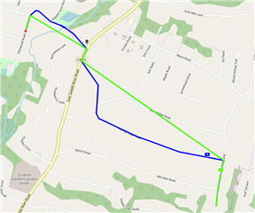
    In the following, the green line is a route in BaseCamp. The blue line is the track that BaseCamp created from the route. The waypoints are where the green lines change direction.

    BaseCamp cheats because it can display the route as a track (where the path follows the roads).

  • A track file consits of track points; hundrets or thousends. Like a bread crumb line.
    A course file consits of some course points like start - crossing x/y street - end.
    Both files mostly are gpx.

    Course files are really just track files with or without "course points" (the "course points" are optional).

    GPX refers to the how the data is organized. It's a text XML file.

    TCX is another type of text XML file.

    FIT is another type of file but it's binary. It tends to be much smaller than the equivalent GPX or TCX file).

    Note that these files can contain multiple "objects": they can contain multiple tracks or routes (or whatever).

    ============================

    You can use any of these three file types to store the same data (whether it's a track or a route or just waypoints.

    It doesn't matter what format you use but, for any Edge, the file must be track data.

    ============================

    TCX and FIT files can contain things called "course points". These typically are turn instructions. These are used on Edge devices (like the 500) that didn't use maps. Other Edges support them too. The devices use them by popping-up a message when you get close to the point. They are also displayed in a list on one of the pages.

    These are separate from (additional to) the "turn guidance" (which show up as big white arrows) that the devices that use maps can calculate.

    ("Course points" aren't relevant to the discussion here.)

  • BaseCamp cheats because it can display the route as a track (where the path follows the roads).

    Ok, that's it!
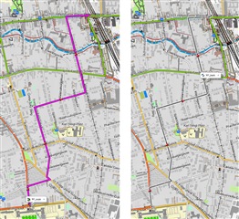
    My Basecamp route is identical with the track - both are following roads.
    (Althoug I have only clicked on the start and end point.)

  • Double click on the route line and you'll only see your two points shown. At the bottom of that screen in the Properties tab, there's a Create Track button.

    You can save a file with just the route points.

    ======================

    Prior versions of BaseCamp had a "display in Google Earth" feature. When you displayed a route, BaseCamp created a track and displayed that.

    When BaseCamp dropped that feature, I wrote a program to provide the same feature. For my program, you have to copy the track (and create it if it doesn't exist).

    https://sites.google.com/view/grouteloader/bc2ge

    The image I posted was one I created to explain what is going on.