ETA calculated completely wrong mostly, not always, so it is not reliable.

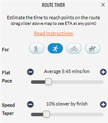
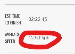
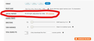
Using ETA for navigation does not always work properly. It usually shows some intermediate turning point, but is not always the same. Using the course function from the Expiore app shows the next turning point as ETA, which should be showed by ETA at Next and not by ETA. The same is true for ETE, which als shows ETE at Next instead of ETE. Using the Navigate function and sync it with the Fenix 8, shows sometimes ETA at Next and later on sometimes correctly ETA, depending on the rest of the track to Destination. Hope this will be fixed soon as for Navigation this is a pretty important function which should be reliable. 

  • same problem. hope it gets solved soon

  • Yep. It happens on most hikes. Really frustrating.

  • Hi,

    this issue has been there for ages and it will still be, as Garmin uses waypoints to provide turn by turn indications. So if you use TBT navigation, ETE / ETA at next will not show you next scheduled waypoint, but next point that will require turn indication. Makes waypoints and TBT features incompatible, unless you use Garmin connect to draw your track. 

    Would make things easy (although Garmin connect is often wrong on elevation), but ETA when using Garmin connect GPS tracks seems to be calculated based on your instant (or 10 seconds) pace, which can vary a lot, especially on hikes or trail runs, and just doesnt provide relevant data - especially when you stop for a few seconds to look at the watch. 

    As a very good workaround, I use Plotaroute for GPS tracks, save them as FIT files and copy them to the GARMIN/Newfiles folder of the watch.
    If you use the timer function of the route, ETA & ETE will be based on your position and estimated input pace (also taking elevation in the calculation), so the ETA/ETE will be very close to reality. It will also be adjusted in real time if you are slower or faster than expected. I have used it for pacing myself on a 82K trail run last weekend, and I was very happy with the estimations the watch gave me.

  • Dear drkglb, thanks a lot for your additional remarks and information. Really helpful, I will try what you suggested on my next skitour in the Alps. I just don't understand why Garmin cannot do better. as a first estimation is pretty easy to calculate. The role of thumb for a first calculation would be: 300 m altitude gain per hour + 4 km/h for the vertical distance, where the latter is only counted at half. So this yields to the formula: T = A/300 + 0.5*D/4, whereas T is the total time required in hours (ETE) and A is the total altitude gain in m and D is the total vertical distance in km. This base formula is true for "normal" hikers and all proofed by many people and e.g. a recommendation from the Swiss Alpine Club. It could of course be adapted for fitter people to dA=400...500 m/h or higher and dD=5..6 km/h or more and OF COURSE it should automatically be adapted regularly with the real-time data from the Garmin Fenix 8. Stops can also be taken into account quite easily and ETA/ETE recalculated after the stop. 

    I did not have the same issues with my older Garmin Epic 2 or older Fenix models, so it seems that Garmin introduced these problems with the later models only. But if I follow other conversations in the forum, it seems a problem that exists on older models as well. So not sure about it. 

    Solving this issues is really not rocket science and it should be solved by Garmin Engineers at the next SW update. May be they come up with a better solution than the one described above, but it would always be better than what we have now. Looking forward to the next SW update. 

  • If you use the timer function of the route

    Could you please explain what you mean by that? How to use this function? Is it a setting when creating the course in plotaroute or when navigating on the watch?

    My experience with ETA (from Fenix 6 and 7) is that it always uses the average speed of the whole current activity. So when I first go flat and then start climbing on my MTB, it was always far off because of course the current speed when climbing is much lower than the average speed. 

  • Hi,

    I meant the "timer" function on the plotaroute website, which allows you to adjust your pace with quite specific settings :

    From my experience, using this field provides a WAY more accurate ETA / ETE when navigating.

  • Makes waypoints and TBT features incompatible, unless you use Garmin connect to draw your track. 

    exactly.

    just making clearer that in this case the mentioned waypoints are "custom waypoints", the ones that will appear in the UP Ahead.

    Garmin loves to cause confusion. Although belonging to the same "outdoor" category now they have decide to call waypoints as "saved locations".

    and to complicate things more the ones that show on UP Ahead some call "custom waypoints" (Strava), cuepoints(RWGPS) and coursepoints(Garmin)... but wait, all points on course(.fit or .TCX) are coursepoints as well trackpoints on a track.(.gpx).

  • I also use the Route Timer function but I consider the final "moving time".

    At the end the ETE (but as moving time) will be very very close. 

    Unfortunately Garmin uses the avg. speed calculated by Plotaroute in the device but not accounting for the elevations.

  • Thank you for the description of the plotaroute timer function. Unfortunately, the greatest uphill slowdown factor is still not enough for me. Either I am too slow or it is not designed for MTB Slight smile