Advice for thru hiking setup

Hi All - I have a Fenix 7X sapphire and will be starting the PCT NOBO on April 01.   I think I already have maps factory installed on the watch but what's the best way to get the "bread crumb" trail?  I don't really need real time turn by turn directions, I just want to check in every few miles or at a trail split to verify I'm on the right trail or which branch I should take.  Any advice?

  • Hello, I prepare for PCT SOBO 2024. I understand, that it is very hard to predict where I succeed to get every day. My way of thinking is to be able to check, that I still follow the route and to get alert when important places like water source or camp place is near. So the solution is to set navigation to some far distance (resuply point) and load as many as possible waypoints? Thank you Rostia

  • Read the 3rd response of this thread.  There the answer lies.

  • Yep, that's what I do. Load key waypoints along your planned route prior to you trip. Once on the trail pick the next waypoint you want to navigate to on your watch and it will guide you. You don't need to have a ton either. Key terrain features along the trail, forks, and water points are ideal. 

  • Just out of curiosity, does the navigation feature eat much more battery than just being in an activity ? Does anybody have experience how much more often you need to charge the watch if you use some form of navigation compared to just recording the activity ?

    Not a through hiker, but I run on trails self-supported, and have avoided to use the navigation features (or off-trail alerts) because I thought it would use the battery too much.

  • I haven't done an exact comparison, but I use navigation quite often and don't notice any difference in battery consumption. I have read that if you have the map page open, it uses slightly more battery because of the screen refresh, but again I haven't noticed any difference and I also have the map page open very often. The battery life on these watches is insane and you should use the features it has available. It makes it even more fun and helpful.

    Final note: GPS accuracy settings and others will impact the battery much more than navigation. It's helpful to experiment with the battery power mode for each activity if you are looking to maximize battery. I used to really nerd out on the battery optimization settings, but I find it better to use the features and enjoy them because it is amazing what this watch can do. If I am in a situation where I really need to conserve battery, then that's a quick and easy adjustment in the settings. Have fun!

  • I've never thru-hiked the PCT, nor do I ever expect to in my life (but I envy those who do!), but living near the PCT I frequently hike sections of it. 

    The waypoint idea mentioned in this thread is a good idea; but one alternative method that I use is saving the trail sections to your watch as individual courses. The PCT is conveniently broken up into 29 sections roughly ~90 miles each (California A thru R, and Oregon/Washington sections B thru L). The sections numbering is official, so they should correlate with any PCT trail guide books and such that reference section letters. Just load all 29 sections into your watch, and load the course for whichever section you're hiking that day.

    The advantage to that, versus the waypoint idea, is it forces you to stay on the official PCT route, whereas the waypoint idea could potentially route you onto other (possibly more difficult or less safe) non-PCT trails/roads when the watch thinks it might be shorter.

    You can download GPX files for each of the individual sections here: https://pctmap.net/gps/

  • Thanks. I will explore the navigation features more ! It is annoying to run down a mountain for a while and figure out you have to go up again because you took the wrong turn...

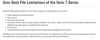
  • Hello, big thank you. This was exactly my concern - not to be misleaded by watch to another route to achieve my waypoint. Just if I understand well, to load all sections into watch would be too much for watch memory, right? If I load them into Garmin explorer and just fortcoming section to my watch, it might work, right? Than all important points like water sources, camps, can be loaded to watch as point of interest if I understand well...

  • I'm not aware of any course limit on the watch - certainly there's enough storage space for all the courses, but I don't know if the course list might have a limit. But that limit, if it does exist, is probably 100 or more. So it should be fine to load them all onto the watch at once.