Advice for thru hiking setup

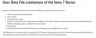
Hi All - I have a Fenix 7X sapphire and will be starting the PCT NOBO on April 01.   I think I already have maps factory installed on the watch but what's the best way to get the "bread crumb" trail?  I don't really need real time turn by turn directions, I just want to check in every few miles or at a trail split to verify I'm on the right trail or which branch I should take.  Any advice?

  • Good luck with the PCT, it’s a fantastic hike :-) Loading in 1 single route of that length will be too much for the 7X so divide it into sections. I always divide them into sections between resupplies, which will normally be in the 100-200 mi range on the PCT. You will need to split your gpx file using a 3rd party app and from there load them into the Garmin Connect App. From Garmin Connect you can transfer to the watch. There are other ways to load gpx files but I find its most accurate when done with Garmin Connect. Turn by turn can be turned off by navigation/alerts/turn prompts/off. I would make sure navigation/alerts/off course is turned on and that navigation/type/course is also on. On the activity map screen I have a Navigation field showing distance remaining displayed so I can judge how far I need to hike everyday (if it shows 100mi and I have 4 days food I know i need to cover at least 25mi/day). Also make use of the watches health features. Things like stress, resting heart rate, body battery can help you make decisions on how hard to push. High stress, high resting heart rate, low body battery are a good indication you need to take it easy. Have a great hike!

  • I don´t know, but perhaps this Garmin map has all relevant informations you will need?

    Trailhead Series - Pacific Crest Trail | Garmin

    Pacific Crest Trail GPS Tracks for Garmin inReach - Julian Straub (mit.edu)

    Good luck, stay healthy and just do it!

  • All the trails will show up on the built in map, but you may have to zoom in to see them. For through hikes, or any hike, I prefer to add multiple waypoints along the planned trail and transfer them to the watch.  Then during the hike, and based on where I am, I can select navigate to a waypoint and the watch will automatically pick the best route based on its heatmap data. This way you don't have to worry about creating massive routes for the entire hike. I did this on a portion of the CT and it worked awesome. Once you hit navigate, you also get all the cool climb pro data and ETA/ETE, among other fun metrics. Enjoy!

  • Use Komoot or Garmin explore app to create routes and import a daily or weekly route.  Plenty of resources on how to do this via YouTube, komoot and Garmin. Routes can be created in advance and can be done from a computer (even a Chromebook) or a smartphone. 

    Make sure to Garmin express (macos or windows) to update pre-installed maps. 

    I recommend you practice importing gpx files on a local trail to learn how make changes on the fly in the field. Also learn how to use navigation features directly from the watch. Regardless carry a map & compass as backup as equipment can break/fail. 

    Goodluck. 

  • As this thread is 10 month old, meanwhile he should have been finished his hike already :-)

  • You are doing a great job - keep it up. 

  • If you did it congrats - share the story. Was the watch useful?

  • Sadly, I didn't get the watch aspects figured out in time.  I should have tried this weeks/months ahead of time as I ran out of time dealing with last minute logistics.  I fell back on my "tried and true" method of using my cell phone with Guthook (never calling it Far Out!) and my InReach.    As far as the hike, I wasn't actually attempting a thru hike, I'm a LASH (long a$$ section hiker).  I was aiming for 4 weeks on trail in 2022 but stopped after 2 weeks.  I made it to San Jacinto and so this year I'll try another 2-4 weeks starting at San Jacinto.  Minimally aiming for Tehatchapi but as far as Kennedy Meadows South.  I've already done the JMT (and HST and Mt. Whitney twice).  Once the kids are out of the house, I'd love to try for the whole thing!  Kind of hard to get Grandma and Grandpa to watch the kids for 6 months...

  • LOL - I here ya (parenthood). Two weeks out is much more than most - congrats! Personally, I've always used a map & compass, but over the last few years I pack a compass & map for just the just-in-case scenario and use a watch gps for quick references.