Course creation

How do you all create courses to follow within a profile?

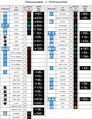
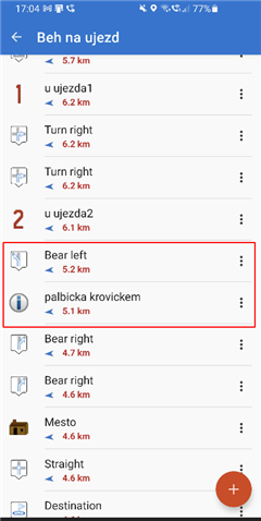
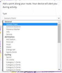
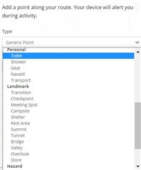
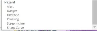
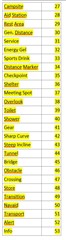
I do a lot of trail running in mountain areas. I find the course creation rubbish with Garmin Connect so I use Plotaroute. I then add waypoints for the summits and anything else like a water source.
I then save this as a .fit file and upload that to the NEWFILES folder within the GARMIN folder using a PC.
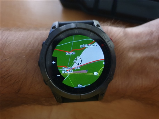
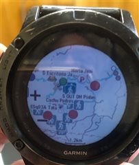
I can then select my trail run profile and the course I created. I can see the distance to the next waypoint etc.

With the purchase of a new F7X Sapphire I thought these waypoints would also be listed in the Up Ahead screen but they're not. Just the start and finish.

Just wondering what everybody else uses to do the same thing?

Also any way of doing this directly from a iPhone or iPad and sending directly to a watch, even using software that's linked to Garmin?

  • Thanks, I found it. My problem was that I was always trying with the 'modify track' function and could not find it there. 

    I have not tested it in the field, but in the Garmin Explore app, the course point icons are not shown correctly, they are converted to colored dots, although the icons i choose in Locus are from the Garmin icon set and are available in Garmin Explore. 

  • Yep, even on actual devices, all icons are some default ones from Garmin no matter what you choose on Locus. Didn't look why. But not big deal I guess when you can name it whatever you want and it will be visible both on map and on ahead list in Fenix/Epix. 

  • hi,

    pls, can you confirm you can also see them all (course_points that turns to waypoints as well?) at once in a general map view.

    This would be awesome.

    Tks,

  • course_points - you mean those with TBT instructions? Yes. 
    I can see their name place on correct location on map of my Epix2, but not icon. Same for "via points". 

    See the picture of part of the track created by Locus Map and imported via dev version of Locus Map for Garmin (not yet public):

    1) that "bear left" is TBT instruction - you will get appropriate arrow near the location. 
    2) "pole" or "palbicka..." are via points visible also on that screen with ahead waypoints to which you are also alerted when approaching. 


    EDIT: see how it looks like in Locus Map 

  • that's nice.

    So far (with Fenix 5x & Plotaroute) I was not able to see TBT instructions on general map view (like waypoints) but only the appropriate arrow/icon near the location.

    I don't have an Android phone so would you mind to post a link(dropbox) for this .fit file so I can test it on my Fenix 5x?

    Thank you,

  • Try this one (didn't want to share previous course).
    https://drive.google.com/file/d/1B_nCV_qG5CNLGKUBVXAj13YCcrMzy9xC/view?usp=sharing

    Track has waypoints with names viapointsX . (can't attach screenshot for some reason now).
    I don't remember that F5 or F6 showed them directly on map like the EPIX and I guess F7, so I am skepical here. 

    BTW, I published Locus Map for Garmin for Fenix7 lineup few minutes ago, so when CIQ Store uncache its data, you will be able to use it to quickly transfer course from Locus Map to F7 like shown few pages back in this thread. See here: apps.garmin.com/.../f15dd655-e734-456e-b8f5-314d287df4a4

    EDIT: version with EPIX also out.

  • Maybe I have solution for you if you want to use mobile app. Im on android phone, installed Komoot and linked it with Garmin account. Komoot now have access to my activities and vice versa. I pulled the activity I liked into Komoot and then saved exported gpx file back to Garmin Connect and it immediately appeard in courses section. Anything You want to do with the activity course you are interested in is much much easier to do in Komoot app. Making changes to course map etc. 

  • I can see their name place on correct location on map of my Epix2, but not icon.

    Hi Jan, 

    After a test I'm also capable to see the course_points names but only at a very high zoomed view.

    In order to see the whole picture of a course with names(icons too) at any level of zoom they need indeed to be waipoints...

    Pls see the picture bellow:

    Regards,

  • Try this one (didn't want to share previous course).

    Thank you but no longer need it.

    I did a test early this morning and names apear but only at a very high zoom.

    Regarding course_points Garmin really likes to make things with TBT and warnings a mess...

    Bellow you find all possible course_points available in GC at this moment.

    Notice the absence  of ALL ARROWS course_points as well "segment_start" and "segment_end"...Garmin Connect force their own "turns" when building the route... ridiculous.

    Good news is that they all work in a Fenix 5x as well even the ones above 26 still not be documented.

    Regards,

    PS: One thing really odd is that I was not able to add course_points that are above 25 using GC mobile but I was using GC Web ... oh Garmin....

  • "With the purchase of a new F7X Sapphire I thought these waypoints would also be listed in the Up Ahead screen but they're not. Just the start and finish."

    Lot valuable information has been said so far.

    I just want to make clear that a classical Waypoint known from the Outdoor devices (Oregon) is handeled as a Location object and is not planed to be a part of a track/course (can be created with explore, Basecamp, the watch itself). So what you can attach to the course in garmin connect are arround 50 diffwrent course point types that should be visible in the Up-Ahead page. Why did garmin not include  waypoint types as coursepoints, well i guess the older one is more outdoor, hunting related and the new one optimized for professionL sports activities.