Course creation

How do you all create courses to follow within a profile?

I do a lot of trail running in mountain areas. I find the course creation rubbish with Garmin Connect so I use Plotaroute. I then add waypoints for the summits and anything else like a water source.
I then save this as a .fit file and upload that to the NEWFILES folder within the GARMIN folder using a PC.
I can then select my trail run profile and the course I created. I can see the distance to the next waypoint etc.

With the purchase of a new F7X Sapphire I thought these waypoints would also be listed in the Up Ahead screen but they're not. Just the start and finish.

Just wondering what everybody else uses to do the same thing?

Also any way of doing this directly from a iPhone or iPad and sending directly to a watch, even using software that's linked to Garmin?

  • I believe you can add points directly from Garmin Connect, by going to Training-Routes, choose the route and then press edit.

    There should be "add point on route" and you can add them directly.

    Fast and simple.

    The only problem I am noticing is that if it is a path that is going to be the same even on the return, maybe the distance from where you are to the point is double. This is because it sees the point directly in the return phase, when you are instead in the outward phase.

    Great feature, but I hope they find a way to better handle this problem.

    Usually my GPS tracks, excluding the rings, also show the total km for round trip.

    If you only use the outward route, and then trackback, there are absolutely no problems.

  • Also any way of doing this directly from a iPhone or iPad and sending directly to a watch, even using software that's linked to Garmin?

    You could try to create the course in the Garmin Explore App and sync it from there. 

  • Really, what you are telling me is that Fenix 7 doesn't recognize externally created waypoints in Up Ahead screen? That seems broken!

    I wouldn't want to rely on Garmin Connect to create waypoints because Garmin's course editor is borderline unusable for planning trail running courses - mostly because of the choice of the maps. Google Maps just doesn't cut it. Garmin Connect does support OSM on the web but the rendering is really poor - borderline unusable for trail running.

    To answer your original question, to create courses I usually use either Strava or PlotARoute. Using Strava makes it much easier to sync with Garmin Connect, but, of course, Strava doesn't support adding waypoints. When I use PlotARoute I sync via a computer the way you described.

    Occasionally I also use Suunto App mobile route editor, which allows me to create a course and import it into Garmin Connect Mobile entirely on my phone. That works surprisingly well as Suunto App route editor is pretty capable and usable. Suunto App is capable of creating waypoints but I haven't tried how well that works when importing into GCM.

  • The only problem I am noticing is that if it is a path that is going to be the same even on the return, maybe the distance from where you are to the point is double. This is because it sees the point directly in the return phase, when you are instead in the outward phase.

    This is going to be a problem for using courses with waypoints during races, especially ultra-marathons. It is common for ultramarathon races to use the same aid station two or more times. On an out-and-back section of a race course, there may be an aid station that runners hit twice. For example, a very popular Leadville 100 race has an entire race course which is 50 miles in one direction, then 50 miles back on the same course. Therefore, all aid stations are visited twice but at various distances. Also, it is common to have multiple different loops that intersect at one point and have a shared aid station there. Basically, in any situation like that it becomes impossible to create multiple waypoints for the same aid station but at different distances. 

    The reason that is very useful when racing is that that allows to track distance to the next aid station and know when there will be an opportunity to meet a crew, resupply, and refill water. 

  • Course creation really is a PIA within the Garmin ecosystem. Garmin Explore is getting there but  still has a long way to go. The maps are pretty devoid of detail and often missing many tracks and are not routable. The course created online are painful to create. Better on mobile devices as maps are routable but on my iPhone the screen is too small. If I do succeed in getting a course with waypoints to my watch I end up with a heap of extraneous turn instructions (as has been noted on many occasions). To get around that I need to remove the course from the watch to my PC then out it back in. 

  • There was recently an Explore update and the maps (don’t know if all) are routable now. But the created courses may not be the the best ones, because of missing details in the maps.

  • This is exactly my workflow as well so disappointed that the waypoints don't show up in "Up Ahead".  Garmin must be labelling these waypoints in a special way to differentiate them from the points used for turn-by-turn.  If one knew how it might be possible to label them in a manner that worked.  I don't have a fenix 7 but perhaps someone can do some digging and understand how it works.  I wish Garmin would just be transparent about what they do.

  • That should be easy. Whoever has a Fenix 7 just needs to copy a course FIT file back from the watch and look inside using one of FIT viewers. I'd do that but I don't have Fenix 7 yet either.

  • Hi,

    Hope this helps: 

    I made a course on the Garmin connect website and saved the fit file: https://www.dropbox.com/s/ba2pevav8a6bugt/GC%20File.fit?dl=1

    Then synced to the watch and saved that file: https://www.dropbox.com/s/as6jilxlpqdspbp/GC%20File%20from%20Watch.fit?dl=1

  • I have also made a course in Garmin Connect Mobile and synced it to my Fenix 6, then loaded the FIT file from the watch and looked inside.

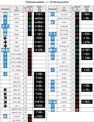
    What I see that the course point have a new patter for the "type" field which is different from what it used to be before. They all have type that looks like "course_point_NN" where NN is a number. It looks like the NN number is used to indicate a waypoint type. For example, an aid station type is "course_point_28".

    It seems that there are some legacy types of course points like "water", "first_aid".

    In contrast, TBT course points have types like "right", "left", "slight_right", "slight_left", "sharp_right", "sharp_left".

    Course points also have a human readable name.