Course creation

How do you all create courses to follow within a profile?

I do a lot of trail running in mountain areas. I find the course creation rubbish with Garmin Connect so I use Plotaroute. I then add waypoints for the summits and anything else like a water source.
I then save this as a .fit file and upload that to the NEWFILES folder within the GARMIN folder using a PC.
I can then select my trail run profile and the course I created. I can see the distance to the next waypoint etc.

With the purchase of a new F7X Sapphire I thought these waypoints would also be listed in the Up Ahead screen but they're not. Just the start and finish.

Just wondering what everybody else uses to do the same thing?

Also any way of doing this directly from a iPhone or iPad and sending directly to a watch, even using software that's linked to Garmin?

  • Do you need internet connection for exporting fit file to watch via "Locus maps for Garmin" or file could be transferred with Bluetooth?

  • No internet needed. Main Android app also have full capability in offline in right configuration. 

    EDIT: aaahhh, not true. Forgot that Garmin broken also this, co CIQ throws error when doing transfer offline even when no internet is needed. Disappointed

  • Hi Guys,

    I wish we had a place to explain the meaning of several "entities" such as Waypoint, POI, trackpoint, course_point, record , etc...

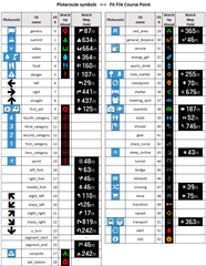
    Bellow you find table 1, a csv file of a fit file just near the end of the entity "record" (that are the coordinates of the route) and the beginning of the entity "course_point" that are the points belonging the the Directions/Notes (as Plotaroute), cue_sheet in other platforms or the Up Ahead in Garmin's.
    I'll be referring how it works on a fenix5x.

    The column Value 1 is what you enter in the Directions/Notes field at Plotaroute.

    The columm Value 6 is "the" identifier, like "part number of product". Unfortunately it is the result of a combination of factors at Plotaroute like described on table 2.

    Table 1

    Type Local Number Message Field 1 Value 1 Units 1 Field 6 Value 6
    Data 0 record distance 37686.48 m enhanced_altitude 639.8
    Data 0 record distance 37688.9 m enhanced_altitude 640.0
    Data 0 record distance 37693.4 m enhanced_altitude 640.2
    Definition 0 course_point name 11 type 1
    Data 0 course_point name ESQ001 Cab type 6
    Data 0 course_point name Asfalto Ca type 0
    Data 0 course_point name DIR001 Cab type 7
    Data 0 course_point name BarBonfim  type 3
    Data 0 course_point name DIR002 Cab type 7
    Data 0 course_point name ESQ002 Cab type 6


    Table 2

    Type

    Garmin

    ST3

    ST3 warnings

    Plota-Symbol

    Plota-Arrow

    generic

    0

    0


    none

    none

    summit

    1

    1


    Mountain

    none

    valley

    2

    2


    water

    3

    3


    Drinking Water

    none

    food

    4

    4


    Food

    none

    danger

    5

    5

    >05 danger

    Warning

    none

    left

    6

    6

    >06 left

    none

    Left

    right

    7

    7

    >07 right

    none

    Right

    straight

    8

    8

    >08 straigth

    None

    Straight on

    first_aid

    9

    9


    first_aid

    none

    fourth_category

    10

    10


    third_category

    11

    11


    second_category

    12

    12


    first_category

    13

    13


    hors_category

    14

    14


    sprint

    15

    15


    Runners

    none

    left_fork

    16

    n/a


    right_fork

    17

    n/a


    middle_fork

    18

    n/a


    slight_left

    19

    19

    >19 slight_left

    none

    Bear left

    sharp_left

    20

    20

    >20 sharp_left

    none

    sharp_left

    slight_right

    21

    21

    >21 slight_right

    none

    Bear right

    sharp_right

    22

    22

    >22 sharp_right

    none

    Sharp right

    u_turn

    23

    23

    >23 u-turn


    segment_start

    24

    24

    >24 segment_start


    segment_end

    25

    25

    >25 segment_end


    As I said before I'm not familiar with new identifiers allowed by Garmin for the Fenix 7.

    Based on the above I do the following:

    1) up load to or create at Plotaroute a track (or route) with waypoints (Plotaroute will add them to the DIRECTIONS/NOTES table) or add any  DIRECTIONS/NOTES up to the limit of 50 (Fenix 5x).

    2) edit them to reflect Plotaroute's behavior/outcome to reflect Garmin's identifiers (codes).

    3) Download the route as TCX file with zero DIRECTIONS shift back and zero TURNING WARNINGS (that would double your final course_points in the fit file limiting your capacity to 25 real warnings). 

    4) Convert the TCX file to FIT using the spectacular CourseTCX2FIT tool from @mcbadger .

    5) copy the fit file to NEWFILES folder.

    Regards,

    PS: I use the tcx converting thing because I was never able to get my warnings downloading directly a fit file from Plotaroute

  • This thread is top notch, this is the kind of content I come to this forum for! Fantastic research done so far.

  • I wish we had a place to explain the meaning of several "entities" such as Waypoint, POI, trackpoint, course_point, record , etc...

    I've always thought that this topic (navigation tips) should be a pinned at the top of the forum.  Much like there used to be a pinned ClimbPro feature description on the Edge 830/530 forums.

  • PS: I use the tcx converting thing because I was never able to get my warnings downloading directly a fit file from Plotaroute

    Can we chat about this offline? The FIT engine is just a library build of the core of CourseTCX2FIT so the output should be identical and I'm puzzled by you seeing different behaviour. (Plotaroute generates a TCX file, converts it to FIT, and downloads that). I had a quick look at the code earlier and the bit that generates course_point messages for FIT just scans through the CoursePoint values in the tcx and maps them to the FIT equivalent. The only difference should be in the sharp_ and slight_ turns, which shouldn't be in the TCX files as they aren't in the TCX spec.

  • Is up ahead a full screen datafield only, or can you for instance put it as a datafield on map screen?

  • They are visible on map and watch will alert about them just like with navigation instructions - so if they are closer to any turn, you will see such waypoints also on that nav panel on map screen. 

  • Can we chat about this offline?

    I've just sent you a friendship request because I can not send you a pvt message.

    Regards,