Could someone please explain in detail some of the following data fields to me. Or if this is better posted in the app developer forum, please let me know! First time posting here ;)
Elevation Plot (while navigating a course)
Most data makes sense. The number at the top left is Total Ascent. Highest and lowest elevations (above sea level) along the course are marked on the map. And the total distance is at the bottom. So far so good. But the number at the top right of the screen is baffling me. Today I created a course that indicated a total ascent (on strava) of 600m. (And when I actually hiked the course my total ascent was 588m.) But when I run the course on the watch, on the elevation plot at the start of the course, the number at the top right has an up arrow followed by the number 1329. Far, far more than the total ascent for the course. I'm guessing that in fact this number is the total elevation change remaining on the course (i.e. total ascent PLUS total descent?) But if that is the case why does it have an up arrow?
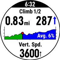
Incidentally, on the ClimbPro screen, the number at the top right is also far greater than I would have expected for total climb remaining on that hill. Is it also showing me total elevation change (ascent plus descent) remaining until the top of the climb?
Could someone please explain exactly what this field is indicating (and also if the field at the top right of ClimbPro is essentially the same data, except of course for just the active climb?)
Average Ascent
What exactly is this data field telling me? A google search reveals it is total ascent divided by total minutes spent climbing. Which would indicated it is an average of METERS per MINUTE while climbing. But I'm getting values like 400 when I hike, so I can only assume it's actually METERS per HOUR?
And on that note, what is the exact logic for what defines an ascent and a descent? If I'm hiking up a hill and go 1) up 100m in 5min, 2) down 25m in 2 min, 3) up 300m in 10min, is it fair to say that my total ascent is 100+300 = 400m and that my average ascent is 400m / (5min + 10min) = 400/.25hr = 1600 m/hr (ie the 25m descent was excluded from the ascent calculations?) Or is it more like my average ascent is (100-25+300m) / (5+2+10min) = 1324 m/hr (ie the 25m descent was included as part of the overall ascent because it was not enough to switch the logic from ascent to descent?) What is the logic to make the watch decide that it is no longer climbing but descending, and vice versa? Does this also explain how ClimbPro decides how many climbs there are in a course?
COURSE
Used this field once in an activity (while navigating a course) and it just read 0 the whole time. I have used OFF-COURSE and that indicates, it seems, the distance in km laterally off the course line. That makes sense. But what is COURSE? Why is it always 0?
And finally...
Are there any data fields that will tell me the following? If not, does anyone know of any IQ App Data Fields that will give me the same information:
a) Difference in elevation between the highest point on my course and my current altitude (just the straight difference - if my hike has a high point of 2000m and I'm currently at 1500m it should read 500m - even if there are actually a number of climbs and descents before I get there.)
b) The percentage of a course that I have finished. If my course is 20km long and I've done 5km along the course the field should read 25%
Thanks in advance for all the help!
Geoff