Course points (Waypoints?) displayed during courses?

I usually use Strava to create routes due to their heatmaps then export them as GPX files, import as a course in Garmin Connect and then sync the course to my Fenix 6 Pro.
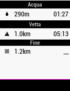
That bit works fine but what I'd like to to is add course points (Waypoints?) of certain positions, for example fell and mountain summits, possible water stop etc so I can see a distance to next in one of the data fields.
Is that possible, if so how and can I use custom text? eg Helvellyn Summit?
Thanks for any help.

Top Replies

All Replies

  • How do you get the contour lines? The TopoActive maps that came with my watch don't include them.

  • Will that upload to the watch as an activity instead of a course?

    No, when you save a fit file from plotaroute.com, it is a course fit file. Behaves exactly as a course from Connect, but you get full control of tbt/course points.

    Create the course in plotaroute from the beginning. You will then get turn directions automatically in the direction list. Delete the ones you don't want. Add new directions or other course point for water, aid, peak or shelter.

    You can also use the 'Abbrevation' feature to mass change/shorten the auto generated direction descriptions.

    If you are an Android user, you can wirelessly download the course to the watch with GImporter CIQ widget.

  • Two ways.

    1) Purchase a map with them (I bought UK Topo Light UK for £20)

    2) Download the map set for your country from here http://garmin.opentopomap.org/

    Unzip the file and copy the contour lines.img to /Garmin on your wtch

    In the activity settings go to map, configure maps and click the contours on

  • Didn't know about the abbreviation feature... thanks for that :)

  • Garmin Basecamp is good for this

    If you're not a basecamp user, you can use plotaroute also to create 'Saved locations'. Maybe not what plotaroute is best for, but if you're in a hurry...

    In plotaroute use 'Annotate map' and put waypoints wherever you want.

    Download with options: GPX, Track, POI's.

    Then your annotations converts to waypoints in gpx file and will be stored as 'Saved locations' in watch and visible as a blue flag on map.

    Unfortunately without correct symbol (always blue flag).

    You also get the course you have on the map as a course in the watch, but without directions. If you want directions, delete it and download it again as a fit file.

  • I've been able to do this just using the course editor in the Garmin Connect web app. Select "Add Course Point", click on the course line where you want to put it, select the type (Gereric, Water, Summit, Danger, etc..) and give it a name. It shows up on my watch just fine, and the datafields all show them. Works great for me, and very easy.

  • Phoglund

    Thats two new things you've taught me today about PlotARoute ! Thanks buddy, nuch appreciated!!

  • I've just read into it a bit more and it seems that if you use garmin connect then it will also add lots of invisible waypoints for the turn by turn instructions

    This is an old story, Garmin copied their new watches  navigation features form watches that did not have vector maps instead of Edge series. The result is that Garmin Connect add all this useful TBT waypoints instead of ask the watch to generate TBT in real time like when you are navigating to a saved location. 

    as a bonus, you can add extra TBT points
    Add new directions or other course point for water, aid, peak or shelter

    The problem is that if you have a TBT point before an AID stopostop water point you can visualize in the data field "distance to next" only the distance to the TBT and is not possible to know the distance to the AID stop or water. 

    I've been able to do this just using the course editor in the Garmin Connect web app

    Unless there are news thanks to the new firmware version, you will display the course point in the map but you will not have any information about distance to this point if you have turn by turn between you and the course point. 

    In Edge series this is working perfectly with a dedicated page with all the distance to the course points. 

  • I tried creating a route in plotaroute and added a few waypoints/directions. Exported as GPX with POI waypoints and then manually copied the file to watch newfiles folder.

    The route showed on the watch with icons for the waypoints, but I could not get the distance to them. It would only show the distance to the finish.

    Not sure what I did wrong. Thought maybe I had the directions in the wrong order on plotaroute but just checked and it's not that. Maybe it has to be a FIT file instead of GPX?

  • The GPX poi export is to get waypoints to 'Saved locations' in watch. With waypoints here I mean point of interest outside of the route/course. Those will show on the map, but you need to use Navigation-> Saved locations to navigate to them.

    In Plotaroute this is points added with Annotate map.

    Use FIT export to get directions and other type of course points along the route. In Garmin watch those type of points are called waypoints when you add data fields to data screens. For instance 'Next waypoint' that show description for next course point.

    In plotaroute this is points in direction list.