Fenix 6X : critical underestimation of the distance

Hello,

I know that several threads have already been written about that, but I want to emphasize.

I had the chance to run with 4 watches today (2 * 2 ) on what I think is a 13km run, and with 2 or 3 over the last days over other activities.

All the watches are fully up to date in terms of sofwares, set to GPS+Galileo, and for the F6x/s set to data recording every seconds.

The sattelites search has been done and left 'green' for 5 to 10 minutes without moving before starting for today run at least.

We are running mostly in the city (buildings).

Here are the results in km. I know that GPX overestimates structurally a bit the distance hence ratios below 100%.

GPX Read FIT Garmin  Ratio
F5 13,16 12,76 97,0%
F5X 13,08 12,89 98,5%
F6S 13,14 12,32 93,8%
F6X 13,24 12 90,6%

That was the first run for the 6S.

Absolutely the same run, a few days ago :

GPX Reader FIT Garmin  Ratio
F5 13,39 13,12 98,0%
F6X 13,08 12,26 93,7%

What I know to be a very close to a 10km run  :

GPX Reader FIT Garmin  Ratio
F5 10,7 10,2 95,3%
F5X 10,61 10,33 97,4%
F6X 10,07 9,25 91,9%

Curiously bike tracking is less crappy, but we are then leaving the city

GPX Reader FIT Garmin  Ratio
F5 53,52 52,36 97,8%
F6X 54 51,85 96,0%

It appears the at least the F6X is underestimating considerably the distance ran.

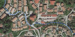
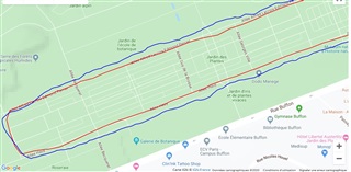
Furthermore the accuracy is really not good : in blue 6X, red 5X, I'm supposed to stay on the "Allée". 5X is pretty good there.

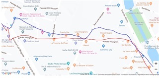
I'm should be seen on the "rue des vinaigriers" :

Has anyone been able to get a reply from Garmin on that issue ?

It is a bit a shame that we need to do this kind of analysis with what is supposed to be a top product.

Merci!

  • I absolutely agree to the OP that the distance accuracy is very poor when GPS signal is weak. in Switzerland we have extremly accurate official maps and I measured the track I run once or twice a week on the online version of the official Swiss Government Topo Map, 1:5000. The track is 14.2 km long and leads mostly through the woods. I did the same run for at least 4 or 5 times now with my fenix 6 and got distances between 12.81 km and 13.4 km. I understand that I cannot expect 100 % accuracy, especially in the woods, but a divergency between 0.8 and 1.4 km at a total distance of 14 km is really bad, it makes a difference in my pace for about 30 seconds. 

    And just to make one point clear: I am talking about the distance the device is calculating for the activity, not about the gpx-track that is recorded. The distance of the recorded track of cource may vary due to the settings for the frequency for recording trackpoints.

  • Bonjour, merci for the feeback.

    At least this is not an isolated issue, the underestimation you are having is quite similar to mine. I will try by deactivating 3D stuffs, knowing that I had them activated on the F5X and the F5 of my wife.

    On the pace I can say from experience that during the run  the 6X shown pace is frequently wrong, average and instant when conditions are met aka straight line & constant pace ( frequent runner all end up by having a pretty clear idea of the pace area they are running after many years of practicing the same paths). But not all the time curiously.

    I suspect an issue in the calculation software.

    I sent an email to Garmin 2 days ago, no reply yet.

    To me, sadly, it means that I will keep the F5X for running for the moment.

  • To me, sadly, it means that I will keep the F5X for running for the moment.

    First of all, make sure to test without 3D-speed and and distance on all devices. I did some tests with it when the F3 was new but with them I never got consistent results and sometimes distances far over the true distance.

  • in Switzerland we have extremly accurate official maps and I measured the track I run once or twice a week on the online version of the official Swiss Government Topo Map, 1:5000. The track is 14.2 km long and leads mostly through the woods. I did the same run for at least 4 or 5 times now with my fenix 6 and got distances between 12.81 km and 13.4 km.

    I think that you should contact Garmin.

    My experience is that my F6 (as well as previous F3) is very consistent for distances even in woods on single track (trail). We have very accurate maps in Sweden as well but since the trails I do don't even exists on the most detailed topo maps I can't measure using the maps and say that's a fair comparison to what the watch gives me.

    I did however measured a run I frequently do using navigation in Google Maps. For the last 10 runs my F6 always got between 10.40 and 10.50km.  Google says it is 10.4.
    The run is mostly on walkways and I carefully checked that Google chooses the same walkways that I run. There is one place where Google don't recognize the walkway and choose another, shorter, way. It would probably add a few meters but not that much (see red line on screen shot).

    To summarize; In tough GPS conditions instant pace is not useful but distances are very consistent and I find no reason to question them when comparing to other devices. In fair to good GPS conditions I know that the distance is accurate and instant pace is ok.

    This is one of the activities for the frequent run: https://connect.garmin.com/modern/activity/4133916983
    This is the navigation in Google Maps: https://goo.gl/maps/nnnaDZQtxXmicrLYA

  • The distance of the recorded track of cource may vary due to the settings for the frequency for recording trackpoints.

    Data is ALWAYS recorded at 1s intervals IRRESPECTIVE of whether Smart Recording or 1s is selected. Those settings do not affect the any distance or pace measures. The difference between the two settings relates to the track display on the map - it might not follow paths as closely as 1s recording - and the size of the resulting data file. Smart recording discards data points if there is no change in some of the measurements for x number of seconds however, all the data points are used for calculating distance etc.

  • Data is ALWAYS recorded at 1s intervals IRRESPECTIVE of whether Smart Recording or 1s is selected. Those settings do not affect the any distance or pace measures.

    I think that was referring to an export of the track to a GPX-file. In such a case smart recording may impact the distance when loading the GPX-file in another tool (such as http://www.mygpsfiles.com/app/)

  • I measured the track I run once or twice a week on the online version of the official Swiss Government Topo Map, 1:5000.

    The only way to accurately measure a track is on the ground with a calibrated measuring wheel. Period. What is the average of the runs? What is the standard deviation/variance? Just taking those two measures you have given, there is an average of 13.1km with a variance of +/300m which, when running on trails, is perfectly reasonable over that distance. Until you accurately measure the track on the ground it simply is not possible or realistic to use a line drawn on a map as a source of accuracy.

  • The only way to accurately measure a track is on the ground with a calibrated measuring wheel. Period.

    I totally agree but there is one difference (apart from being accurate) between that and what a GPS device will give you and that is distance impact by elevation. On normal runs this shouldn't be a problem since the impact due to elevation is negligible but on longer runs with a lot of elevation it may.

    There are features on Garmin devices for 3D speed and distance but the only make things worse.

    As far as I know there isn't any standard for measuring distance on trail runs (competitions) as it is for marathons and other sanctioned competitions? 

  • Thank you for your feedback. I used to run the same track with an old forerunner and this device always ended up with distances between 13.6 and 13.9 km, whereas the F6 calculates around 12.8 to 12.9 at the average, so in my opinion this is quite a big difference.

  • There are features on Garmin devices for 3D speed and distance but the only make things worse.

    I don't believe these features make it worse. Arguably it makes things more accurate but who knows? On trail runs there are so many variables that impact on the actual distance.

    As far as I know there isn't any standard for measuring distance on trail runs (competitions) as it is for marathons and other sanctioned competitions?

    Correct. Although I know some years back the Tarawera Ultra's original course was measured with a wheel. However, given the number of GPS watch users who reckoned it was longer (around the time of the 310XT), the event director decided to use the GPS measurements for the distance because he got fed up with the complaints lol! There's only so many times you can listen to people crossing the finishing line, stopping their watches and saying "That was 84km not 80!". When we organised the Kaweka Mountain Marathon some years back we provided distance from Garmin watches we had used with no complaints from participants.

    If you have the ability to repeatedly run the same course you can build up a good estimation of the 'true' distance. I have been running a loop where I live for quite a number of years from 2008 to 2019. Using a number of different Garmin watches the distance has been around 10.5km +/- 50m. The route is a mix of open and light tree cover on open paths and single track. No idea what it would actually measure but since the results are always within a few metres, I'm happy.

    In short, unless you can accurately measure the track on the ground, the best guide to distance is repeated measures over the same course. Measuring a course on a map online can only give you an approximation irrespective of how good those maps might be.