Some of us using the Fenix 5 and 945 have noticed a problem with the predicted elevation plot/profile for an autorouted path, even just a straight-line path. It's discussed in https://forums.garmin.com/outdoor-recreation/outdoor-recreation/f/fenix-5-series/139809/projected-elevation-profile-still-wrong-since-v-7-10-when-navigating-a-route
Note that the problem DOESN'T appear for a saved activity or a downloaded course.
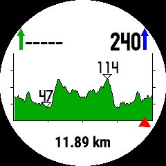
The problem shows up as a predicted elevation profile that is twice as 'bumpy' as it ought to be and apparently is for a 'there and back again' rather than a one-way route. It doesn't happen all the time though... if it did, it'd be better, but it's unpredictable.
I'd be fascinated to know it the Fenix 6 has the same problem.
Easy to test, you don't actually have to follow the path as this is about what the watch is predicting your elevation along the path will be, not the elevation that you actually do (that's another bug), just choose some point to navigate to, preferably something with a predictable elevation difference from where you are now. Saved locations are good if you have any but 'around me' features and 'points of interest' work too. You can have Activity set to Direct Routing in your "navigate settings->routing" settings if you want, that'll get you a straight line path but the elevation graph should still show you the ups and downs along that path. (You do need a map with elevation data but on my watch at least, the default maps have that)
Using the F5 menus, it's like: navigate->points of interest->cities->choose something->goTo->hit Start, wait for it to get gps fix and finish calculating and then scroll down until you see the elevation graph for your path. Is it suspiciously symmetrical? Does it show a ridge where you would expect only a slope? Or twice the expected number of ridges/mountain/bumps between you and your destination? Test it a number of times, say up to 10 times, to see if it is consistent. Using the same destination is OK.
Thanks in advance for any results! Here's a picture of a 'bad' result. Note how symmetrical it is about the centre. There should only have been one big ridge, not two. BTW, the distance shown is actually correct, just that the elevation graph is wrong.