Projected Elevation profile when navigating a route MAYBE FIXED (Was a bug between v 7.10 and 21.0)

On my Fenix 5x I noticed a very strange thing when looking at the 'projected' elevation plot when navigating from point A to point B in a straight line rather than following roads or tracks. Not a closed route. (i.e. point B is 11 km from point A in a straight line) Version of the software on the Fenix 5x is 7.10 and the maps involved are Aus and NZ Tope lite V5 and Garmin Cycle Aus/NZ 2016.0. Both maps are turned on in the navigation settings. Navigation setting for routing is set to 'direct'. (Although note that it also does something similar if I set it to Pedestrian, or Mountaineer or one of the other choices)

So, just to clarify, I am talking about the profile that is calculated for the projected route, not the route travelled already. i.e. this is what the navigation sw is telling you you will go up and down if you walk in this straight line from where you are to where you want to be. What an excellent tool this would be IF ONLY IT WORKED PROPERLY!


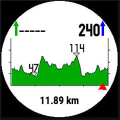
The elevation plot looks strangely symmetrical. In fact it looks like the elevation plot I would expect, but doubled and reflected around point B as if it is the plot for A->B->A again rather than just A->B
.
Above is a picture, and I assure you that the real elevation between A and B should not be symmetrical like that. It's showing as green not blue because I haven't hit the 'start button yet. Starting doesn't change the shape of the graph, though as I hike along the route, the elevation profile changes from blue to green and corrects itself until at the end it looks about right.

I have also seen similar strangeness when looking at elevation plot for routes that follow roads and tracks out in the bush whilst hiking, though I don't recall them being symmetrical, they were definitely wrong and overshot the destination by about a factor of 2 as well. Drove me crazy trying to work out what it was doing!

This doesn't always happen. Sometimes abandoning the navigation and starting again gets the correct elevation plot, but very often it doesn't. More often than not it is wrong.

I haven't noticed this on closed routes that I have recorded, i.e. ones that come back to their beginning.

Looks like a bug to me.

Anyone else noticed this problem, or is it just me, or maybe the particular maps or settings I have chosen?

Thanks 

  • not sure about your issue exactly..but Im also having problem with my elevation chart. When I start my end point elevation changes. For example, the other day i started at 1700ft and was going got 4000ft. But at one point it read 4300 and the next time I looked at the chart it says 4100. I dotn know why it wasnt correct and I dont know why it changes at all.
  • Tcornall. The same problem. Strange, but sometimes it's good (on the left) and sometimes it's wrong (on the right). Same route, same map, same settings:


    My post on the Polish forum: http://www.garniak.pl/viewtopic.php?f=2&t=17216&start=135#p198872
  • Tcornall. The same problem. Strange, but sometimes it's good (on the left) and sometimes it's wrong (on the right). Same route, same map, same settings:


    My post on the Polish forum: http://www.garniak.pl/viewtopic.php?...rt=135#p198872


    Yes, this what I see too. A recent update to v 7.60 doesn't fix it either... Sadly, I am almot accustomed to the problem. If the graph looks symmetrical, I use the centre as the destination, and if it doesn't, I treat the end of the graph as the destination.

    This is clearly NOT going to work if the route really is symmetrical (as GPS_Maniak pointed out above in his post on the Polish forum), such as up and over a couple of similar sized ridges.
  • I do see that version 7.60 has fixed/changed some behaviour with the altitude graph whilst following a route. It now appears to update better and when the aoutorouter for a GO TO changes its mind about suggested path it appears to change the profile too. Whether it does it properly is hard to tell... However, I still quite frequently see the problem described above where the altitude profile along the initial route is incorrect and is apparently for the round-trip-route from current position to selected destination AND BACK rather than just the route from current position to selected destination.
  • Hi all,

    I am seeing the same issue with elevation plots. We're going to get this fixed. Thanks for reporting it.

    Could you let us know when you first noticed the issue? Did you notice it before 7.10?

    Thanks,
    Mel
    Garmin Outdoor Software Quality Team

  • I noticed a problem during the first trip to the mountains: in May 2017
  • This is what I got back from the support team:
    Hi all,

    I am seeing the same issue with elevation plots. We're going to get this fixed. Thanks for reporting it.

    Could you let us know when you first noticed the issue? Did you notice it before 7.10?

    Thanks,
    Mel
    Garmin Outdoor Software Quality Team


    I can't say if it was in version previous to 7.10 or not as I hadn't tried it before that.
    Great to hear it is a confirmed problem and being addressed, thank you!
    Terry

  • I can't be sure yet, but the last few times I tested this, using Version 8.0 firmware, it seemed to work OK. At least the altitude profile given for the route didn't look 'reflected' as alluded to above.
    Nothing about it in the release notes though.

    Oops, no, sorry, definitely still there. It really shows up best if you set the Navigation activity ROUTING option to DIRECT ROUTE.
    Still waiting for that fix...
  • I don't see any mention of a fix for this and already we are up to beta for 9.53! I know 8.0 didn't fix it. I'll wait for 9.2 to roll out and see if it did, though it isn't mentioned in release notes.
    Just tested it with version 9.2 and the problem is still there. I think we've been forgotten...

    Well, I just heard from Odsweng again (In June), and he's poked the issue to try to get it resolved. Maybe in a future release it'll work properly.
  • Up to version 10.0 and I still see this problem....