Serious bugs in GPS: inaccurate data or stop of position in map when using All Systems + Multiband

After being happy about the better GPS of the Epix gen2, I notice more and more prolems, the best GPS settings mode: All + Multiband has always been used in the examples described here:

I use my Epix quite intensively (Since 20.01.2022), for example when navigating while guiding mountain tours, and on some days I notice really serious dropouts in the GPS.

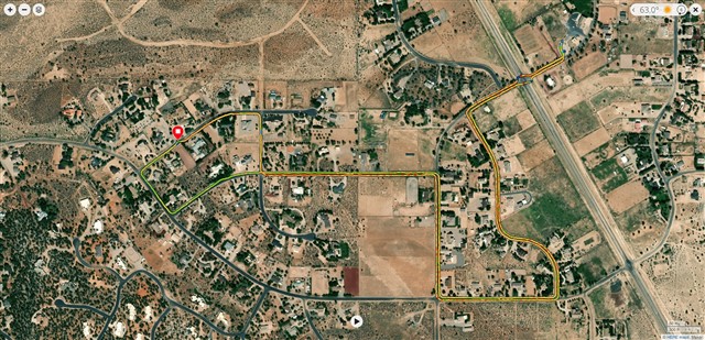
1.) 7.24 In this track I was in the park with my daughter. Basically, most of the track is shifted to the right, but we were only in the green area. This happened after we went through an underpass, after which there was a strong offset to the right (east), which did not correct itself until the end of the activity (type: other). Since I was traveling with my child, I didn't mess with the settings, for example changing the GPS mode, which sometimes helps (see below).

The end and start should actually be exactly on top of each other.

As you can see, the drift/offset is about 200m

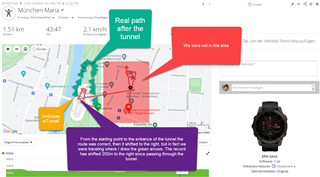
2.) 7.20 As you can see, the track is on the way there, on the way back suddenly in the creek. I then had to change the GPS mode several times (e.g. to GPS only), then the location wandered around, at some point it worked again. It was a winter tour, therefore no strong slope. in the data fields was the field for GPS reception (the bar display) configured: 5 bars.

This happened after 4.5 hours on flat terrain, until then everything was correct.

3.) 7.20 Using the new option "Snow Shoe"

After I calculated a route to a poi on the watch: GPS stopped completely and the own location on the watch stopped even if we moved. The altitude changed while we were moving, while the total estimated path length (data field -> navigation) became longer and longer. We were already several km on the road and I started the navigation to the poi after about 1.5 hours, when we decided at a fork in the road to the final destination.

2 restarts did not help.

Also in the activity type "Hiking" the same problem when navigation by POI was selected. Navigation by track on the other hand worked, with the known bugs (problems with elevation profile).

The next day everything ok.

I make 5 tours per week, on which I use the navigation and there are days, there the whole thing totally freaks out, or it occurs so strange GPS dropouts, as shown in 1 and 2.

My feeling on this is: all systems + multiband is accurate, but freaks out sometimes. I plan to do more tests in the "GPS only" setting.

Top Replies

All Replies

  • Your experience is very different from mine.  Here is a track from a 3 mile walk I took today:

    All systems + multiband and every second data recording.  This is typical of this or a similar walk I do every day.

    This walk was with software version 7.24, but I see no difference with 7.20 and the same settings.

    I have found the GPS accuracy to be excellent.  Distances on repeat approximately 3.05 mile walks on different days is always within +0.01 miles. Start and stop points overlay perfectly. Locations in reference to the map are also ideal - i.e. it's easy to see which side of the road I was walking on, where I stopped, turned, etc.

    HTH

  • (Czech language for translate) Dnes se mi stalo úplně přesně to samé. Byl jsem na výletě asi 15km. Zastavili jsme se v restauraci na oběd. Dal jsem tedy pauzu aktivity. Po obědě jsem aktivitu znovu obnovil ale zbytek trasy byl posunut asi o 400m doprava. Zaznamenaná trasa správně kopírovala tvar cesty v mapě ale cesta byla o cca 400m vedle...  Divný bug :-(

  • Here is the translation:

    "Czech language for translate) Today exactly the same thing happened to me. I was on a hike of about 15km. We stopped at a restaurant for lunch. So I took a break from the activity. After lunch I resumed the activity but the rest of the route was moved about 400m to the right. The recorded route correctly followed the shape of the path on the map but the path was about 400m off...  Strange bug :-("

    Thank you

  • Můžete mi prosím poskytnout screenshit nebo fit soubor? Potřebuji ji jako oporu. / Can you please provide me a screenshit or the fit file here? I need it for support. 

  • I have found the GPS accuracy to be excellent.  Distances on repeat approximately 3.05 mile walks on different days is always within +0.01 miles. Start and stop points overlay perfectly. Locations in reference to the map are also ideal - i.e. it's easy to see which side of the road I was walking on, where I stopped, turned, etc.

    This has been my experience also…very good tracks, consistently repeatable reported distances. Even through built up areas it shows my on the correct footpath.

    I was even surprised to see that it has correctly recorded me on either the left side or the right side of the same footpath depending on whether I was walking out or back….incredible.

  • On your shown map from the park, I read "consulate general of Russian...". Maybe they use something like GPS jam, because your position is transfered/shifted about 200 meters? I don´t say, thats it, but this is a possibility for your expirience there. Or have you visited the park before without such problems?

  • With the Epix I was there for the first time. However, these are "only" consulates, not embassies, so there are no armed men running around, as is actually the case with the Americans a few kilometers away.

    Let's say that might be so. then it probably should have started earlier, because the problem occurred when we were farthest away from these consulates (there are several).

  • So maybe there is something wrong with hw/sw on your device, if you are using All + Multiband!? The others (like me), can't help that we don't have a problem with it. So it seems not to be a general problem, which effects all users (only some) with an Epix. Have you already sent the relevant activity files and a link to this thread to the Garmin Epix/F7x series fw team for investigations?

  • It's always the case that a bug doesn't affect all users, so I can't understand these totally pointless postings: It wasn't like this on my walk.

    I posted this here so that the Garmin employees reading here can read it and find other users who also experienced the problem - and there was one, see above.

    Because with the German support of Garmin I had contact and they have sent as always only the usual garbage with FAQs and so. They often do not understand what you want and admit that they do not have the devices.

    How can I contact the team you mentioned?


    Since I got the watch, I have recorded about 60 activities, most with GNSS.

    Each of the above problems occurred only once, but they did occur and need to be investigated and fixed.