New DEM (Digital Elevation Model ) Map, question

Hi, do you receive these updates ?

For Fenix 7 Series this is the first time after many years that Garmin provide information about DEM.

Before with Fenix 6 Series the information and updates was specific and shown.

If you already have it before, even with a different versionning (map also change there versioning to something like that), this is an interesting information.

Thanks

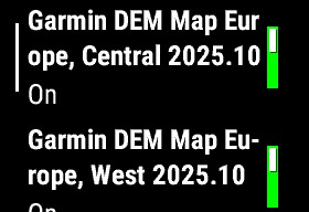
20250507 - NEW - DEM (Digital Elevation Model ) Map

  • DEM Map Europe - Central  – 2025.10 (new)
    • DB517000A.img - 283 Mb
  • DEM Map Europe - West– 2025.10 (new)
    • DB518000A.img 240 Mb

Top Replies

All Replies

  • Not sure whether this has anything to do with the discussion you folks are having because, frankly, I'm starting to see distinction without difference between your points of view.

    Not Enduro 3, but common to other watch platforms, I have been comparing the maps listed on my watches (tactix 7 Standard (MIP) in this case) and the Map Details shown for the watch on Garmin Express - there are often differences.

    Within the time frame of the discussions in this thread, I noticed some significant differences.

    On 22 APR 2025 the firmware was updated to v.21.19 using Garmin Express. The following differences (highlighted in bold) were noted in Map Manager on the watch and Map Details on Garmin Express:

    *** Map Manager ***


    • TopoActive North America Map Version 2025.10
    • Garmin DEM Map NA, Canada/Alaska 202… Map Version 25.10
    • Garmin DEM Map NA, Middle America 202… Map Version 25.10
    • Garmin Public Land Map v2024.10 Map Version 24.10
    • Golf Australia & New Zealand Map Version 25.10
    • Golf Europe Map Version 25.10
    • Golf North America Map Version 25.10
    • SkiView 2025.15 Map Version 25.15


    *** Map Details on Garmin Express ***


    • Map: CourseView Europe, Middle East, Africa & Oceania 25.10
    • Map: CourseView North and South America 25.10
    • Map: CourseView Pacific 25.10
    • Map: Garmin Public Land Map 2024.10
    • Map: Garmin Ski Map 2025.15
    • Map: TopoActive United States 2025.10
    • Map: TopoActive Middle America 2025.10
    • Map: TopoActive Canada and Alaska 2025.10


    Tactix 7 System Software Version 21.19

    Of note is DEM Maps were visible in Map Manager for the first time - I was never able to see them here before.  I was glad to see these as I had been curious about whether they were regularly updated, or even available.  Altimeter calibration using DEM had always worked for me, so no change there.

    Then, on 19 JUN 2025 the firmware was updated to v.22.06 using Garmin Express. The following differences (highlighted in bold) were noted in Map Manager on the watch and Map Details on Garmin Express:

    *** Map Manager ***


    • TopoActive North America Map Version 2025.10
    • Garmin DEM Map NA, Canada/Alaska 202… Map Version 25.10
    • Garmin DEM Map NA, Middle America 202… Map Version 25.10
    • Garmin Public Land Map v2024.10 Map Version 24.10
    • Golf Australia & New Zealand Map Version 25.10
    • Golf Europe Map Version 25.10
    • Golf North America Map Version 25.10
    • SkiView 2025.15 Map Version 25.15


    *** Map Details on Garmin Express ***


    • Map: Base maps 7.0
    • Map: CourseView Europe, Middle East, Africa & Oceania 25.10
    • Map: CourseView North and South America 25.10
    • Map: CourseView Pacific 25.10
    • Map: Garmin Public Land Map 2024.10
    • Map: Garmin Ski Map 2025.15
    • Map: TopoActive United States 2025.10
    • Map: TopoActive Middle America 2025.10
    • Map: TopoActive Canada and Alaska 2025.10


    Tactix 7 System Software Version 22.06

    Of note is both DEM Maps were no longer available in the Map Manager on the watch. I was surprised, but not overly concerned as Altimeter calibration using DEM continued to work well.  But also, in the Map Details on Garmin Express I saw for the first time ever Map: Base maps 7,0!  What are these? Could they be a new series of base maps which incorporate DEM data? I don't know.

    Bottom line is I note these "housekeeping" changes made by Garmin in how they manage details of the maps available, but I have noticed absolutely no difference in the performance of the watch.  Altimeter calibration using DEM continues to perform without issue.

    Finally, just as a point of information, here is what I see on a newly acquired tactix 8 51mm Solar after update to the latest available software on 18 JUN 2025:

    • TopoActive North America Map Version 2025.10
    • Garmin Public Land Map v2024.10 Map Version 24.10
    • Golf Australia & New Zealand Map Version 25.10
    • SkiView 2025.15 Map Version 25.15
    • Golf Europe Map Version 25.10
    • Golf North America Map Version 25.10

    ***Map Details on Garmin Express

    • Map:Base Maps 9.0
    • Map: CourseView Europe, Middle East, Africa & Oceania 25.10
    • Map: CourseVieww North and South America 25.10
    • Map: CourseView Pacific 25.10
    • Map: Garmin Public Land Map 2024.10
    • Map: Garmin Ski Map 2025.15
    • Map: TopoActive United States 2025.10
    • Map: TopoActive Middle America 2025.10
    • Map: TopoActive Canada and Alaska 2025.10

    Note that DEM Maps are not available on the watch, but Map: Base Maps 9.0 is available in Map Details in Garmin Express.

    What does it all mean? I don't know for sure, but my guess is that Garmin are simply doing some housekeeping on their map data in order to make it easier to manage and more consistent across platforms.  I can't buy into the various theories about these changes signalling an expansion of the features only available behind a pay wall, or Garmin trying to cover some kind of mistake, or some portent of limiting of features on older models in favor of newer models.

    Of course, YMMV.  Just my US$0.02.

    HTH

  • Hmm. The DEM map is selectable on my 1030+. There was a recent update (5/22/2025).

    I wouldn't call a change here "really strange".

    It seems more like "mildly interesting but likely not important".

    If your "fact and research" say otherwise, it might be interesting to hear about it.

    Because the last time i saw a change in file management was for GPE.bin that was pushed to device and after that blue triangle problem for everyone.

    This file is updated all the time. 

    Garmin doesn't generally provide notes about it being updated.

    In rare cases, a bad version of the file is produce. It isn't surprising that Garmin would say something then.

    garminrumors.com/.../

    Not sure if DEM is a good sign for us or Fenix 7.

    No information about it suggests it's a routine update.

  • Not sure whether this has anything to do with the discussion you folks are having because, frankly, I'm starting to see distinction without difference between your points of view.

    It could be the visibility stuff is enabled in the map file itself.

    DEM data isn't updated that often (AFAICT).

    One might expect that a map named "Topo" anything would have DEM data itself. If so, it might make sense to be able to disable other DEM maps.

    That is, maybe, the DEM map being visible is related to Garmin using the Topo maps as the standard maps.

    (The cycle maps used by the Edges didn't contain DEM data. Those maps have been replaced by the Topo maps.)

    What does it all mean? I don't know for sure, but my guess is that Garmin are simply doing some housekeeping on their map data in order to make it easier to manage and more consistent across platforms.  I can't buy into the various theories about these changes signalling an expansion of the features only available behind a pay wall, or Garmin trying to cover some kind of mistake, or some portent of limiting of features on older models in favor of newer models.

    I basically agree with this.


    Garmin is clearly doing some general map "housekeeping". They are replacing the "cycle" maps with the "Topo" maps. (Indicating they are moving to producing one set of maps for all devices.)

    It's possible this helps them with their subscription stuff but there doesn't seem to be any indication that people will lose any features they already have.

  • Thanks for this complete follow up regardin Maps by release, i did not take the time myself and do not have enough knowledge. Thanks !!!

    ---

    I'm using Garmin Express for all updates, but do not directly use Map Management section through it.

    Then i do not pay attention to "Base Maps" showing and versionning.

    This should be the default gmapbmap.img – Worldwide Basemap (NR) - which very light in terms of details/size

    https://shop.talkytoaster.me.uk/how-to-identify-and-or-remove-garmin-pre-installed-maps-on-a-fenix-etc

  • That’s a good link.

    ========================

    As you noted, the Basemap doesn’t have much detail (and it can’t be used for routing). It doesn’t take up much space. It really doesn’t need to be updated very often (it would be good enough even being old).

    The Basemap is useful but not required.

    • It provides something to look at for areas you don’t have detailed maps for. (Less of an issue if you have world-wide coverage with detailed maps.)
    • It’s used at very low zoom levels to make updating the screen faster (where drawing all the detail would be an unreadable mess anyway).
  • Of note is both DEM Maps were no longer available in the Map Manager on the watch. I was surprised, but not overly concerned as Altimeter calibration using DEM continued to work well.  But also, in the Map Details on Garmin Express I saw for the first time ever Map: Base maps 7,0!  What are these? Could they be a new series of base maps which incorporate DEM data? I don't know.

    A bit of a sidenote:

    When I had an Enduro, so a watch with barometer, but without maps, I sometimes had a feeling that it might have been a hidden DEM data. So not a visible file in the watch, but as part of sw.

    Or not a hidden DEM data file, but the watch may have been collecting  DEM data from my phone via GC app (connected DEM)

    I had this feeling, because ambient pressure changes seemed to not have an adverse effect on altitude accuracy. One can say that GPS elevation was the factor behind the weather compensation, but my old experience says that continuous altitude calibration on oldtime devices with only barometer and GPS elevation like 60csx or a newer Fenix 3 HR worked differently like on my Enduro.