I have found that when I am on an out-and-back hike where the watch goes off-course or auto-pauses (since disabled) that it is a coin flip if the watch "rejoins" (term I am making up) the course at my location on the outbound or return leg of the course. This seems really straight forward to program because the watch knows that I'm only a certain distance into the route (see pictures).
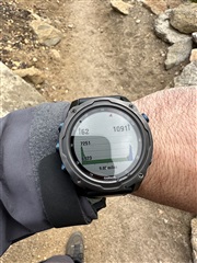
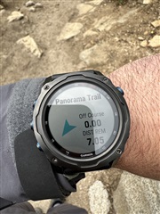
Details from pictures:
- course downloaded from alltrails directly to device with garmin connect
- 9.05-mi course total (see the small text on bottom of elevation plot)
- At the time of taking picture, I was 2-mi in and the watch knows this, evidenced by the "DIST REM" of 7.05-mi
- Notice that despite knowing I'm 2-mi in, it "rejoins" the course at the return leg of the course where I was on the outbound (notice it has plotted in green the elevation change I had thus far, then just skips to the same spot in the return, blue) and at the time it knew I was going the correct direction because the markers on the compass are pointed the direction I'm walking.
Am I doing something wrong or is this a bug? Its maddening.
I see the same thing happening in this post, but no resolution