I don't understand what you're asking. Are you having trouble using the device to navigate while swimming on the surface? Or is it not recording the locations of your dives?
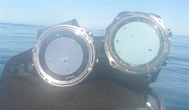
The MK2 is not able to tack my location over the water. I have the MK1 which I have used for 100 dives and I can hit my saved dive site accurately. The MK2 gets lost, something is wrong with it. Notice the MK1 vs MK2 show different locations.
Are you using the Map activity profile or something else? Is it set to GPS only or also using GLONASS or GALILEO? If you open the Map activity on land does it show your correct location? Is the CPE (satellite ephemeris data) current?
I have used my Descent Mk2 to navigate to dive site GPS coordinates on the surface and it seems to work fine. If yours is defective then you'll probably have to contact Garmin since there's nothing that users can really fix.
I am using the Map activity. The MK2 can navigation just fine on land, but when I get over the water it gets lost. Maybe the MK2 is looking for streets and gets lost when it cant find them. I have used the MK1 for years and never had an issue. You can see in the photo the MK1 & MK2 have me at different locations, that should never happen. I have been calling Garmin for a year and they had me do a system reset and sent a new watch, nothing fixes the issue. I will call again this week.
In the Map settings do you have "Lock on Road" set to On or Off? Have you tried using the Navigate app instead of the Map app?
Have you tried comparing coordinates with a third different GPS receiver? It's possible that the Mk2 is actually correct and the Mk1 could be wrong, but wrong in a consistent way. Those two devices use completely different GPS hardware internally. So if you originally recorded the dive site GPS coordinates with the Mk1 then maybe the coordinates aren't quite right? What we've done for some of the local shore diving sites is have divers tie in a reel on the site and then send up a floating buoy containing a regular full size GPS receiver with a good antenna. After it floats for a few minutes it gets a really accurate position fix which we can use as a reference later.
It's also not recommended to place two GPS receivers right next to each other. Supposedly that can cause inaccurate results. I'm not sure exactly why it's a problem, but I remember DC Rainmaker stating that he has to keep devices separated during comparison tests.
The Lock On Roads setting is off, I believe that is off by factory default. However, it does seem like the MK2i is trying to lock onto roads so I will double check that.
I am sure the MK1 is correct since it gets me to my exact saved locations perfectly. The MK2i will stop tracking my position and then jump around if I hit back and zoom back in so something is wrong with the MK2i. I have used the MK2i without the MK1 and it can never track my position.
What is frustrating is the MK1 works perfectly, used it to find my saved dive locations over 100 times. I can see the MK2i will stop updating my location while I am kicking out. So now I have to use the MK1 for finding my dive location, and the MK2i for my dive computer with air.
I will let you know if Garmin can find a solution.
Have you put the Descent into dive mode and got a GPS fix before you decent?
As I understand, both Mk1 and Mk2(i) have to be in the the dive mode ahead of diving and get a GPS fix before you descent in order to record the entry location.
Having the exit location recorded without the entry location, the dive record does not have the dive site identified automatically.
It would be nice that the dive records had used the exit location to name the dive site if the entry location was missing.
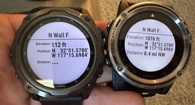
They show the exact location. The elevation is different. If you are using the barometer to determine elevation you can run into issues unless you calibrate. I often just use the GPS elevation. For my purposes, it works.
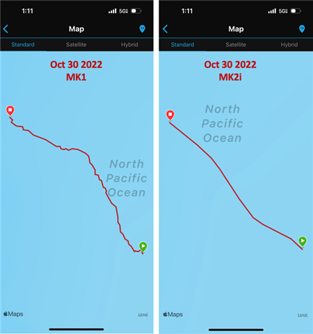
If case you are interested in a follow up to this issue, I was able to use both MK1 and MK2 in Boat Mode which records the route. Look at how different they are, the MK2 is not correctly tracking my location. When the MK1 tells me I hit my location, the MK2 is still hundreds of feet away. Seems to be a major defect with the MK2. Maybe the MK2 is just drifting on the inertial and not getting GPS fixes, who knows.


 .
.