Problema with the altimeter measurements

Hi everybody!

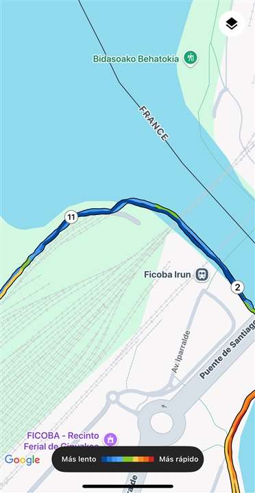
Im using the watch to run usually and there is no race with an accurate altitude measurement. I’m making almost every time the same route, I have a little hill to “climb” to see the the measurement when I go ad come backwards in this point the gps route is in the same spot, but the difference between this two points is very big. The route starts higher that it ends, even if the start and the beginning is the same…

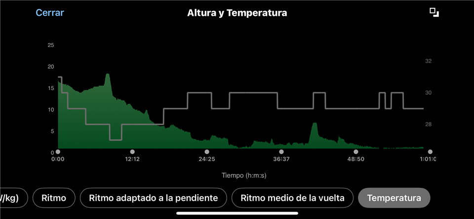
One thing that I have to mention is that the temperature measurement is activated with a maximum 3 degrees threshold, I’m not sure if it is enough to alter the altitude / barometer.

attached in the picture: this two peaks are the same gps position.


Any ideas? Is your altitude inaccurate too?

thanks in advance!!!

  • Hello

    I'm sorry to hear you are having this issue. If you are having trouble with the altimeter, there are a few steps I would recommend trying initially:

    If this continues, I would recommend contacting Garmin Product Support. 

  • Hello Laurie,

    thank you so much for you support.

    I have fixed id changing the configuration of the altimeter to “only altimeter “. 

    Now the altitude is 100% accurate ( I have repeated the same route a few times).

    One thing that has worsened is the altitude in static  (looking at the widget) .

    Finally set the altitude before every run and that’s it.

    Watch I don’t understand is the altimeter in automatic.

    In this scenario, in a race, the temperature of the watch increases, the wind could affect to the measurement etc.

    • Auto (Default Setting): The watch actively monitors pressure changes and automatically switches between altimeter mode (for elevation changes) and barometer mode (for weather changes) as needed.

    Looking again at the first graphic that I sent in the previous post this error seems to be a constant, the decreasing looks like proportional, maybe a calculation factor?…

    Again, thanks for the answer!!

  • Thx @Garmin-Laurie for the inputs!


    My current configuration on my Fenix 7s sapphire solar is

    • Altimeter
      • Auto calibrate
      • Sensor: only altimeter
    • Satellites
      • All + multiband
    • Activity screen
      • Added "Altitude" & "GPS altitude"

    Before recording an activity (mountain hiking with big altitude difference), I always make a manual Altimeter calibration with GPS and see that "Altitude" & "GPS Altitude" are quite the same.
    During a hike with changing whether conditions, Altitude is wrongly moving (mostly during my pause) where GPS Altitude is still correct.

    I clearly understand why with pressure changing but the issue is that on recorded activity file (fit) the recorded altitude is the one influenced by pressure (blue line) and not the GNSS one (red line recorded with dual-band multi-GNSS), which is quite invariant and much more accurate.
    https://postimg.cc/s1N1Zs2t
    Also note that the correct maximum altitude is the GNNS one (~25m lower for red line!)

    Can I actually choose which value ("Altitude" or "GPS altitude") is recorded on my fit file?

    If not, it'll make sense to be introduced in a future firmware version! (my current is 22.06)

    Note: as Fenix 7S Sapphire Solar use GPS + GLONASS + GALILEO for "GPS altitude" the exact term might be GNSS altitude to avoid confusion...

    ...Still have 403 uploading my 2 pictures, U can find them on postimg.cc: s1N1Zs2t 56LKF930