New altimeter test

Today I did an interesting test and I want to share the results.
- garmin instinct 16.0
Part 1
-In my house I calibrated altimeter and barometer with "GPS option", 1338 meters above sea level. It's ok, it's the real one.
-without using the activities, I have driven to the sea, 130 km of displacement.
-The GPS altitude dropped steadily, almost the same as the one my car has installed. I appreciated very good data
-I arrive at the beach, and while my low-end cell phone, with a UTM viewer application, indicated 3 meters above sea level, the garmin gave 70 meters above sea level..... why is there such a huge difference? DATUM is WGS84

Part 2
-on the beach, I calibrate again altimeter and barometer with "option" GPS, at 4 m. All ok I think.
-I get home, and the garmin indicates 1275 masl, instead of 1338 masl

1) why is this happening?
2) is the GPS included in low-end cell phones really better than the one with a garmin watch?
Thank`s

Top Replies

  • 1) why is this happening?

    There several possibilities:

    • Changes of the atmospheric pressure during the activity. The ride certainly took several hours, and the displacement was great enough…

All Replies

  • 1) why is this happening?

    There several possibilities:

    • Changes of the atmospheric pressure during the activity. The ride certainly took several hours, and the displacement was great enough, for the pressure to change by several mbars. The difference of 63 m (1338-1275) corresponds to the MSLP difference of ~7 mbar (that's quite few and very well possible - during the day there can be pressure changes up to several tens of mbar)
    • Temperature changes - a sudden change of the temperature of the watch will result in a different pressure reading and hence a change of the altitude. The dependence is not linear, but simple tests with the watch show the deviation or roughly 1m / 1°C. Check the temperature graph of the activity for changes of temperature. Also when you stopped riding (air cooling) and exposed the watch to the sun while staying still on the beach, the temperature certainly rose. Oppositely, if you swam a bit, the water cooled it down
    • Water entering the pressure sensor port would also have impact on the pressure reading, and hence it would change the altitude

    And, of course, it is quite likely due to the combination of all those factors.

    2) is the GPS included in low-end cell phones really better than the one with a garmin watch?

    The GPS has nothing to do with it. The altimeter uses the GPS just for the calibration. Either automatically at the start of the activity, or manually. Otherwise the pressure reading is used for calculating the altitude.

    If you prefer using the GPS elevation, you can edit the screen of the activity, replacing the Elevation field with the GPS Elevation data field. The barometric elevation will be still logged into the activity file though, but you can switch to the topographic elevation in Garmin Connect Web by enabling the option Elevation Correction.

  • hi trux!

    without using the activities, I have driven to the sea, 130 km of displacement.

    Thanks for your time.
    I am going to be more specific in my comments, because I think the English translation was not as accurate.
    Actually there are two issues: one the altitude, the other the location coordinates

    1) The watch was never activated, I did not use any sports activity, because the traveler was by car.
    Because of that, I never saw a change in temperature and sweat or anything.
    All day I was at a constant temperature with air conditioning.
    The day was ugly, with rain, that can explain what you tell me about the barometer.
    I understand that you tell me that in the activity, the gps is only used for the coordinates, and the altitude is always generated by barometer. I thought I always used GPS triangulation, like an extrex or a cell phone.

    I understand what you are telling me, but something does not convince me: a common user does not have your specialized knowledge.
    I only realized that if I travel from my house (1338 m) to the sea (0), the clock never shows 0, but rather several positive tens of meters.
    And if I put it at 0, when I return it will no longer reach 1338. Even if I leave it for a few days "resting" and getting used to the climate or situation in my house.

    Attached photo from this morning.
    and if I do the same home-beach-home bike ride with the activity on, the same thing happens.

    But other colleagues, with watches from other brands, do not have that problem. we went out together 1338 m, and to the beach they are at 0 (+-10m)
    And with all the problems that the instict, and other high-end garmin watches have, I wonder if I should change.


    2) The comparison with the cell phone is as follows:

    I did a scavenger hunt game at school with my students. 50 young people with 50 cell phones of all brands and ranges, with a simple application that indicates UTM + elevation

    EVERYONE was very appreciated, but if I wanted to use my instinct to follow the game it was impossible... there were always several meters (10 to 15) of difference with the UTM coordinates and about 10m of elevation difference.
    That's why I asked if my watch is much less quality than cell phones. I understand that it is not an EXTREX or a point camera device, but to be less performant than a cell phone, I did not expect it.
    If that's the case, now I understand why many cyclists only use their cell phones, connect Estrava and just charge it on their ride.

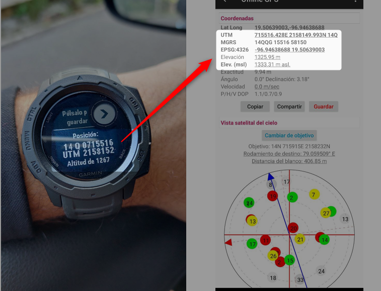
    In the image, I show a location outside my house, leaving the cell phone and instinct for 30 seconds without moving it.
    Same UTM, but no elevation

  • In the image, I show a location outside my house, leaving the cell phone and instinct for 30 seconds without moving it.
    Same UTM, but no elevation

    Note : 

    „Elevation calibrated by GPS is accurate to +/-400 feet with a strong GPS signal.“

    https://support.garmin.com/en-US/?faq=En8Ve2Q5VX7nbFL0Tkuub9 

    Calibrating the Altimeter

    To maintain accurate readings when using the altimeter and barometer on these watches, the sensors need to be periodically calibrated. By default, the watch will calibrate automatically using the GPS elevation reading whenever a new activity is started. However, depending on the GPS signal strength, these elevations can be off by as much as +/- 400 feet.

    The sensor can also be calibrated manually, providing an accuracy of within +/- 50 feet. To maintain this level of accuracy the watch will need to be periodically calibrated over time. For the best accuracy, it is recommended to do this hourly. 

    The watch offers two ways to calibrate; auto calibrate and manually calibrate.“

    https://support.garmin.com/en-US/?faq=qyfmQF7Au284m7pXMi5ie9 

    —-

    Try the following :

    Calibrate the altimeter outdoors using the "DEM" method while you have paired the watch with your smartphone and the Connect app has access to your smartphone's location services.
    Then post photos of this experiment compared to the smartphone app you used in the example.


  • All day I was at a constant temperature with air conditioning.

    Other Factors to Consider

    „Some factors that might impact the function of the altimeter and barometer include: …climate controlled buildings which can have slightly different pressure indoors compared to the ambient pressure outside…“

    https://support.garmin.com/en-US/?faq=qyfmQF7Au284m7pXMi5ie9