This discussion has been locked.
You can no longer post new replies to this discussion. If you have a question you can start a new discussion

Differential Altitude Measurement? (total ascent + total descent)

I've had the Instinct Solar for a couple weeks now and am really liking it. I'm coming from a Casio Pathfinder that I've used for years in the mountains and I'm finding the Instinct Solar to be a perfect step up with some great features while maintaining the simplicity that I'm used to.

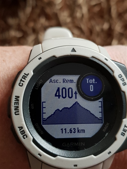
Anyway, I used the Pathfinder primarily for it's altimeter. One feature I used on every single trip was it's "differential altitude". At any point during the trip, you could zero the measurement (making the setpoint your current elevation), then the differential altitude would tell you the difference between your current elevation and the setpoint. This is useful if you have a known elevation gain or loss ahead of you and want an easy readout of your progress. This is not a cumulative ascent or descent measurement.

The problem with using 'total ascent' is that it counts all ascents (cumulative ascent), so there's potential for number to be higher than the "differential altitude" if the trail descends at all on your way up.

I don't see a way to get this "differential altitude" feature on the Instinct Solar, but I thought I would see if I'm missing something or someone has some ideas. One workaround I thought of was keeping total ascent and total descent visible, then you simply add them together in your head. Not ideal but I couldn't figure out a better way.

Thanks!

  • This is a data screen I have on the watch when I am navigating a saved course while trail running. Is this what you are looking for?

  • Thanks for the reply. This is good to know about and sort of what I'm looking for, except I'm after something that can be set on the fly, perhaps multiple times during a trip, without navigating a predetermined course. I'll give a couple examples of how I used the feature on my Casio.

    In most cases I reset the differential altitude once at the beginning of the trip, knowing my objective is X feet above my current elevation. On the ascent, I have an easy gauge of my progress (easy to judge feet per hour based on diff altitude and time - though the Instinct has the vertical speed measurement which I still need to play with) and how close I am to the objective. On the way down it works the same way, telling me how close I am to my starting point by counting back down to zero.

    Occasionally, I'll reset the measurement during a trip usually for the purpose of navigation. I can use the diff altitude to indicate the next rest point or when I should take a new bearing (based on looking at a topo and my current bearing).

    Mostly all of my outings involve ascending to some high point, so this diff altitude measurement has been very useful to gauge how myself or the group is performing. This is especially important on big objectives (mountaineering) where timing and ascent rate is critical.

    Really the 'total ascent' should work fine most of the time, but there are those outings where the route might have some ups and downs mixed in which counts towards the total ascent. I suppose one good thing about the Instinct is that it's using barometric pressure for altitude so you're less prone to elevation noise contributing to the total ascent (something that's a problem with GPS-based elevation readings).

  • I played around with the elevation readings and vertical speed on my last ski tour outing.

    The vertical speed is a nice feature since it gives a ft/hr readout, but unfortunately I found the time period for the measurement to be too short to make it really useful for me. Essentially it gives more of an instantaneous vertical speed, rather than something averaged out over multiple minutes. This works great for an activity like cycling or running where you care about that instant vertical speed (as a measure of climbing intensity), but for slow moving/long duration activities like hiking/mountaineering I, personally, care about my vertical speed averaged out over the last 15 minutes or more. It would be nice to be able to change this period setting, but I'm sure the algorithm is more complicated than that. I saw another post with the same question.

    https://forums.garmin.com/outdoor-recreation/outdoor-recreation/f/instinct/235375/vertical-speed-setting

    As far as my original question about the differential altitude measurement, looks like I'll just have to make do with using the total ascent and descent readouts and doing a little math in my head. This does seem like an easy feature to implement since the data is already there, i.e. diff altitude = total ascent + total descent.