Hi,
since I got the device, the altimeter graph is not working while navigating. Update to 10.13 did not change this. 
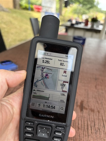
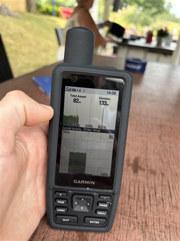
Does anybody still have the same issue? Any way of workarounding it? Garmin, any plans for fixing this?
Cheers, thanks
Simon
Hi,
since I got the device, the altimeter graph is not working while navigating. Update to 10.13 did not change this. 

Does anybody still have the same issue? Any way of workarounding it? Garmin, any plans for fixing this?
Cheers, thanks
Simon
Update October 21, 2026: We have released SW version 13.08 that includes a fix for this concern. If you are experiencing this, and have not already, please install this update.
If you are still experiencing…
For The Garmin Response Team:
Get a GPSmap H1 and also get a Garmin GPSmap 66sr (or 67)
Mark a waypoint on both GPSmap units, let say 5 km. away. Now create a Route to that waypoint on both units.
Compare…
Hello,
I am experiencing the same problems with the altimeter plot. The plot shows the elevation profile ahead, but it disappears after a short while. This seems to be the same or similar problem as in this…
Thank you for this information. If this occurs again this next time, I would love to collect some additional details. You can upload these here: supportforms.garmin.com/.../
Good morning LF,
I'm not sure if your engineers are working on the same Altimeter problem here ...
I'm talking about the BLUE EXPECTED / UPCOMING elevation plot when hiking a created route. The altimeter itself works fine for me but not the BLUE Expected altimeter profile when following a created route.
Maybe there is a problem with reading the DEM files belonging to the topo maps. Maybe for some reason they are not read anymore hiking a created route after a while, resulting in the BLUE expected Altitude profile to disappear. The DEM files cannot be found anymore during this hike; maybe a programming error on the directory/map stucture within the H1 hardware.
Background info on DEM files:
DEM files in your Garmin map directory stand for Digital Elevation Model files. They store terrain height and elevation data used by your device.
What They Do
• Hillshading: They provide 3D terrain shading and shadows on your map view to show mountains, valleys, and slopes.
• Elevation Profiles: They power the elevation graphs and plots for your hikes, runs, and bike rides (giving you actual height data instead of a flat line).
• Elevation Calibration: Your watch or device can use local DEM data alongside GPS signals to calibrate and improve starting altitude accuracy.
As I mentioned earlier in this forum subject;
"... Get a GPSmap H1 and also get a Garmin GPSmap 66sr (or 67)
Mark a waypoint on both GPSmap units, let say 5 km. away. Now create a Route to that waypoint on both units.
Compare the GPSmap H1 with the GPSmap 66sr or 67 and see what happens when you walk towards the waypoint. I can almost guarantee that you wil notice that, after a while, the expected Blue altitude profile disappears on the H1. When playing with + or - key or the rocker switch, sometimes the expected Blue altitude profile will show up.
The GPSmap 66sr (or 67) on the other hand, keeps showing the expected blue altitude profile without any issue ... You can use the + or - key or the rocker switch and still the altitude profile remains visible.
I'm (we are) just wondering, does the Garmin Response Team (Engineers, in this case)) has the same experience when this was mentioned earlier and does Garmin also use the Garmni 66sr or 67 to investigate this problem? Does the Garmin Response Team (Engineers) test / investigate the mentioned issues in a field situation?
..."
Kind regards,
Roel