GPSMAP 67 ELEVATION

GPSMAP 67

Calibration on GPS

Calibration auto: permanent. Calibrate with GPS

I walk on flat level  20m (on map) . The elevation is increasing 20 m  to 50 m and the elevation given with GPS remains between 20-30 meters

How do you explain this?

What is the process to compute elevation according to pressure? Is there an explanation?

  • My device version is 8.5.

    I ask me if hole of pressure is partially close.

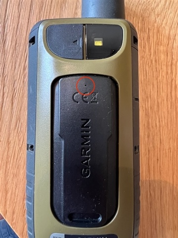
    Do you know where is it on gpsmap67 ,

    I have found nothing (waterproof )

  • Afaik the hole is on the back of the unit, at the top of the spine where you attach the carabiner and other accessories.

    In my tests with 8.50 I get the best results for ascent/descent values with Auto Calibration set to Once. I don’t manually calibrate as the elevation displayed is pretty close to actual elevation (within accuracy as specified by Garmin). And I do a manual reset of the Trip Computer before starting recording my activity.

  • By the way to see if altimeter hole was not obstructed I don't find it and gpsmap 67 is waterproof.

    Do you know where is it? What is the accuracy of gpsmap 67 altimeter?

  • The hole for the barometer sensor is just above the CE logo, see red marked area in the photo:

    The accuracy of the altimeter is about +/- 10 feet, see Elevation Accuracy of Outdoor and Fitness Devices for more details.

  • Thank you,

    I think it is not a good place, I am using carabiner attach and when it rains altimeter is obstructed by attach.

    I will change this with a necklace passing through the bottom of my 67. 

    I have seen in altimeter/plot Type/ Ambient pressure/  that ambient pressure resolution with 0.1 mbar (ie 1meter)

    I will see if there is an improvement.

    I have on my car Garmin which show gps elevation. 

    The GPS elevations given by both (car an 67 are the same) and react very quickly.

    The elevation given with my 67 follow very slowly and have a difference of 10 meters (the difference is 0 when I calibrate) 

    I don't understand why?

  • Note that GPS elevation is inherently not very accurate. As a general rule it will have around 3 times of an error compared to horizontal accuracy.

    So you may be comparing the elevation reported by the GPSMAP to a number that is actually less accurate.

    You can also show a GPS elevation data field on the GPSMAP so better to compare the reported elevation with that value.

    And due to it being a consumer device there will always be a margin of error, as stated in the article I linked to previously.

    Edit: note that if you wear the GPSMAP on a lanyard with the antenna pointing down, this may influence GNSS accuracy and result in less accuracy.

  • I think concerning GPSMAP pointing down is not very good as you told.

    To calibrate I will take elevation given on TopoMap and using Carabiner attach with some distance from hole of altimeter. Waiting than Garmin integrate in elevation ,elevation given on map and I will suppress auto calibration continuous (refer to  GPS)

  • In case it helps, here's my calculation on the elevation effect of changing barometric pressure. 

    In normal weather conditions, barometric pressure changes by less than 10 millibars/hour -- much less when there's no frontal passage.  At elevations of less than a few thousand meters, 10 millibars/hour would amount to about 87 meters/hour of elevation change.  That fast a change might be expected during frontal passage.  Absent frontal passage, the expected change in an unadjusted altimeter would usually be less than 25 meters per hour equivalent to less than 3 millibars/hour.

    Also keep in mind that a 67i can be set to continuous calibration.  So if the 67i were so configured and a GPS error were in the same direction as a change in barometric pressure, one would expect the error to increase faster..

    I never use continuous calibration.  My practice depends on whether I need to use the energy-saving feature Expedition Mode.  If I don't need Expedition Mode, and plan to leave the 67i on throughout my activity, I will set it to calibrate once at the start.  I may then manually calibrate it myself at the start.  On the other hand, if I'm using Expedition Mode, I will set the 67i to not recalibrate automatically, and I will manually calibrate the elevation at convenient times.  I believe the 67i resets the altimeter from GPS every time it resumes full power mode from Expedition Mode, which creates an erratic elevation track in the track recording. I've rarely done it, but in vertical terrain where it's hard to know your elevation, you can calibrate the altimeter from barometric pressure obtained through the Weather feature of a 67i.

    Looking at Total Ascent or any of the "Trip Data" metrics can be deceiving for reasons unrelated to GPS error or changing barometric pressure, since there has been no consistency to when they start and stop measuring a change.  For example, Odometer and Trip Time would start/stop incrementing when recording is started or stopped, whereas Total Ascent/Decent would increment while the 67i is turned on regardless of trip recording.  Other Trip Data metrics start or stop when Expedition Mode is activated or deactivated.  I've suggestion several times over the years on the Garmin Share Ideas page that these inconsistencies be fixed.  As far as I know, my suggestions have had no effect and the inconsistencies still exist.

  • Thank you for your reply.

    You are right I can calibrate my altimeter with pressure obtained through the Weather feature

    I think the experiment of altimeter when my car was 60km/h was wrong because the variation of pressure creating with speed air pressure.