How to change grid coordinates to GPS coordinates for use on topoactive maps?

On Qld national parks camping information, the location of bush camp sites is given as below

  • Map sheet—Beechmont 9541-42. Grid reference—166 851.

I cannot find this on Garmin Explore maps. 

How do I convert that grid reference to a format that GE can use so I can then plan my own route? 

Cheers

  • Do you actually HAVE the map? Without it, I don't think you're going to be able to resolve this.

    Beechmont is not the name of a USGS map. (I was hoping this would be a 7.5 minute quad name, but it is not.) The grid reference refers to the intersection of a vertical and a horizontal grid line on the map. The grid lines may be visible on the map. The grid reference numbers (or letters, or numbers and letters, or whatever) would be in the margin of the printed map, with tick marks. On some maps, you would have to actually draw the grid from tick to tick with a straight edge.

    In the US, the most commonly used grids are latitude/longitude and UTM. There is also the State Plane coordinate system. The grid reference you give above does not look like any of the commonly used grids. So it might be an ad-hoc grid used for this particularly map sheet.

    Note that information on back country campsites in National Parks does change over the years. You probably ought to try to get current information for the area in which you are interested.

  • Sorry, did not realize that you are in Australia. I believe that this is the map in question:

    https://apps.information.qld.gov.au/data/v2/QTopo/StaticMap/QTopo/25k/9541-42/pdf

    If you look to the right of the map, will see that the grid is UTM. The 66i does support the GDA2020 datum. (Settings > Position Format > Map Datum; the position format would be UTM UPS). So you can simply set the unit to UTM. UTM coordinates are normally given with easting first, then northing. If I read the shorthand correctly, the grid reference 166 851 would be about two thirds of a square east of the 16 vertical grid mark. it would be just a bit north of the 85 horizontal grid mark. (These are 1000 meter grids.)

    In order to enter the full UTM coordinates into the GPS, you would then have to "expand" the grid reference shorthand to the full UTM coordinates. The full UTM coordinates of the corners are shown in the margin at the map corners. Customarily, you would use the origin in the lower left corner (since "eastings" get bigger as you go east; "northings" get bigger as you go north). But you can use any corner as long as you understand how the arithmetic works. However, you ALSO need the zone.

    I AM, however, confused by the citation of MGA Zone 56 on the map. The UTM coordinates are "relative" to a zone. And that's how you would enter them into the 66i. The zone is designated by number (east to west zone number), and a letter (north to south zone designation).

    Best guess would be that it really IS zone 56 (possibly J). Certainly, the map represents just a small part of the zone. But I'm not really sure.

  • Thanks for that, my apologies for not being clear on country. Lol. Anyway, I shall try to work through the nomenclature you mention, and use google to get a better understanding of the terms. Yes I do have the map, so shall follow your advice & see what I come up with. 

    Thanks for the help. 

  • What you have been given is what is called a six figure grid reference which is way past it's use by date in todays environment of GNSS and electronic vector maps. It's only useful if you have the particular hard copy map sheet it relates to, and it also rounds to the nearest 100m which is poor accuracy. 

    Your 66i can do way better than that if they provided standard UTM coordinates, try to get those if you can in future and it becomes seamless.

    In your case to resolve this particular example:

    For the Easting add the 5 to the front and a couple zeros to the end, e.g. 516600

    For the Northing add the 68 to the front and two zeros to the end, e.g. 6885100

    Your zone is 56, don't get too hung up on the latitude band letter. Zones are functionally only really either north or south. All of the Southern hemisphere UTM gets a false northing of 10,000,000m so the Northing you enter will automatically be a unique southern latitude.

    Most software & many devices simply want to know if your Northing is in the Northern or Southern hemisphere. The 66i and Garmin software does want to know the latitude band letter, presumably this is only to confirm the hemisphere. However as long as you enter a southern band letter e.g.one of the Aus latitude bands G,H,J, K or L the 66i will automatically correct this for you when you save the waypoint. Try it, enter one of the other letters and save it and see what happens.

    Also set the datum to WGS84 to get better accuracy. Garmin incorrectly added the GDA2020 datum based on the published transformation which was actually between GDA94 to GDA2020 and assumes GDA94 is still equal to WGS84. It's not, our plate has moved and the very reason we introduced GDA2020 to be again equivalent to WGS84. So if you use GDA2020 you will automatically inherit the GDA94 shift on top of the usual positioning error.

  • Thanks Wombo24,

    That's certainly technical. I shall work through it all until I understand it. All info is good info. Very much appreciated. 

  • Me again.

    I am pulling my hair out. I changed the position format to UTM.UPS and it's us in Ng WGS84.

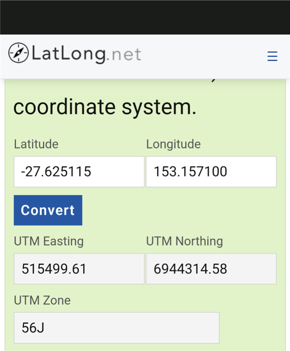
    I copied a Google maps co-ordinate for a hike point about 20kms from me. I then used an online converter to find the UTM. Then using 'Mark' I edited the shown UTM to the one I wanted. As soon as I clicked on done, it took me back to the waypoint page, but the coordinates were totally altered. 

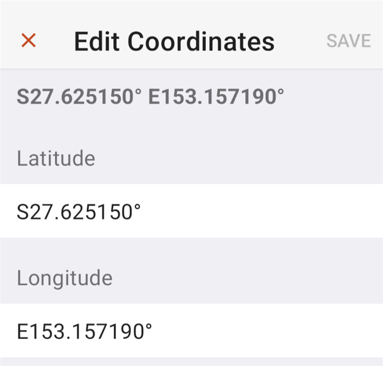
    I then went on to the explore app, found the same geographical point and looked at 'navigation info' it was presented in standard lat/long decimal. I have looked to see if that format is in the 66i but it's not there. 

    So I am now at a position where UTM doesn't work, and any points I can find to start planning a hike are in a format not supported by this very expensive GPS. 

    What an I doing wrong? Attached some screenshots. The top one is from Explore app. 

  • Don't despair it's a great unit that works fine for me everywhere, love it.

    To use full decimal Lat Lon coordinates such as these you would set the position format to hddd.dddddd and make sure you set them as South & East for Aus.

    I've just followed your steps here in Scotland and overridden my marked coordinates here with both your Lat & Lon and UTM coordinates, they both save fine and show up in Aus at the start of a walking track near the junction of Daisy Hill & Quarry Rds?

    One possibility I can think of, did you leave the leading "0" on the Easting when you overwrote it? UTM zones are long and thin with less metres across the E-W so that number will always be shorter by one digit.

  • Your a Godsend Wombo24, the issue was two fold, 1) I misunderstood the formats shown and 2,) I was overwriting the leading zero with, in this case, the No 5 starting the UTM co-ordinate. 

    So once I corrected both those, then both worked well. Phew, now I can get on and get used to this unit. 

    Thank you so much for your excellent help.