Why can't the 66i record a reasonably accurate elevation track when in expedition mode?

Why can't the 66i record a reasonably accurate elevation track when in expedition mode?  Expedition mode is tremendously valuable for certain applications like long backpacking hikes.  But documentation that I can find is scant.

Please don't dismiss my question.  I already know the design purpose for relaxing tracking accuracy is to reduce power consumption.  And I already know Garmin doesn't publish its firmware source code.  I'm looking for an answer of detail somewhere in between.  In other words, "How does expedition mode save power?"

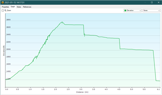
The lateral tracks are somewhat less accurate in expedition mode but still useful.  The elevation record associated with those tracks however, is so wildly off target that it probably should not even be recorded.

Is it doing less processing?  Is it turning the receiver off in between track points?  If that were true, then users could alter power by changing tracking point frequency.  Are there elevation settings that would change the accuracy of elevation tracks in expedition mode?

Next, is there anything I can do to get a more accurate track without grossly increasing power consumption?  Then, is there anything Garmin could do to its firmware code?

  • Good illustration, atlas_cached.  Thanks for posting it.

  • I can't do the geometry, either. And I don't really understand the trilateration process involved in computing a fix. I have, however, seen mention of the fact that handheld receivers tend to use ONLY those satellites which are 25-30 degrees or more above the horizon. This inherently limits the accuracy of the vertical fix.

  • Reminder: This thread is about expedition mode.  I started the thread then got carried away into the satellite geometry detour.  But the central question here is why is elevation tracking insanely inaccurate when the 66i is in expedition mode.  To recap, the 66i is slightly less accurate horizontally when in expedition mode, but is drastically less accurate vertically in expedition mode than it is when not in expedition mode.

  • Nobody here is going to know why. Open a support ticket.

  • Thanks, twolpert.  You're probably right about no one here knowing.  My post is just a shot.  Maybe I'll get lucky.  If not, then nothing ventured nothing gained.

    I don't think support can help either.  This is an issue inside firmware.  I've registered bug feedback about it.  I wish others would too. 

    If there's a workaround, I'd like to see it documented.  If it can be fixed, I hope Garmin will do that.  If it cannot be fixed, I hope Garmin will change add a warning window to the firmware. 

    I don't want to complain too loudly.  Expedition mode is an essential feature for me, even if it does destroy the elevation track.  I don't want its battery saving ability significantly diminished in order to record a useable track.

  • Filing a bug report is what I meant by opening a support ticket. They might (have) know(n) about a workaround, but the important thing is to get the bug documented.

  • Examining my track after a recent hike, I recognize that one irrational elevation change (300 foot vertical drop between track points 37 horizontal feet apart on a Park Service fire road) occurred when the 66i "resumed" from expedition mode.   and then went back into expedition mode.  30 minutes later, it recorded an 800-foot drop in elevation on the same fire road between track points 108 horizontal feet apart on the same fire road.  I don't know if the 66i resumed from expedition mode then.  It might have. 

    As I said earlier, these are not outlier single points.  The profile looks more like stairsteps where the treads are at a plausible slope at the wrong elevation.  Then there is a vertical drop to a new tread that proceeds at a plausible slope though at the wrong elevation. 

    For comparison the uphill part of the hike was not in expedition mode.  My path was in a narrow steep canyon. The downhill portion along a more gradual fire road that had a better view of the sky was in expedition mode.  This is a typical example.  Extreme examples are much worse.  The horizontal track does not show these kinds of inaccuracies even in expedition mode.