Why can't the 66i record a reasonably accurate elevation track when in expedition mode?

Why can't the 66i record a reasonably accurate elevation track when in expedition mode?  Expedition mode is tremendously valuable for certain applications like long backpacking hikes.  But documentation that I can find is scant.

Please don't dismiss my question.  I already know the design purpose for relaxing tracking accuracy is to reduce power consumption.  And I already know Garmin doesn't publish its firmware source code.  I'm looking for an answer of detail somewhere in between.  In other words, "How does expedition mode save power?"

The lateral tracks are somewhat less accurate in expedition mode but still useful.  The elevation record associated with those tracks however, is so wildly off target that it probably should not even be recorded.

Is it doing less processing?  Is it turning the receiver off in between track points?  If that were true, then users could alter power by changing tracking point frequency.  Are there elevation settings that would change the accuracy of elevation tracks in expedition mode?

Next, is there anything I can do to get a more accurate track without grossly increasing power consumption?  Then, is there anything Garmin could do to its firmware code?

  • From jig2: (1) “ Would elevation tracks be reasonably accurate in expedition mode if elevation were derived from gps data?  I don't think so, but I'm not sure.” (2) “Also, if you know a way to set elevation tracking to use gps elevation, I'm not aware of how to do that.  Does setting altimeter calibration to "continuous" accomplish that?  Also, I wonder how much power is consumed by the "continuous" setting when in expedition mode.”

    Answers: (1) Perform the determinations of the relative precisions (standard deviations of normally distributed data) as described below and you can make that resolution yourself. (2). I am not sure if that can be done. I posed that question a year, or so, ago on the geocaching technical forum. I received a mess of nonsensical gibberish, none of which was informative. I requested, but never received a keypunch by keypunch sequence by which I could impose a continuous stream of GPS derived elevations. My presumption is that selection of Continuous will provide that while not recording; however, starting recording will switch back to barometric.

    Calculations of Precisions of Elevations

    We need to calculate the precisions, standard deviations, of three sets of data. One set is required GPS derived elevations. However, two for barometrically derived elevations as the devices displayed values are combination of two. Of those two sets, one is the precision of the barometric sensor itself and the other is the variations in ambient pressure due to weather changes at constant elevation.

    When I gathered these sets, I performed all readings in my backyard for elevation consistency.

    For the barometric sensor, I recorded 20 displayed barometric elevations, one every 5 seconds for a total of 1 min. and 35 sec. I assumed no pressure changes due to weather in that short time period.

    For weather effect on the barometric values, I manually calibrated the barometric elevation to that of my backyard and never again until finished. I recorded one reading each day for twenty days. Note that each of these readings was the combination of the weather effect and the barometric sensor variability.

    The GPS values were also collected once per day for twenty days.

    The precisions of the three sets were calculated as described in the Wikipedia article linked below.

    The elevation of my house is included in a link below.

    I calibrated the barometric sensor from the NOAA station also linked here, it is within ½ mile of my house at 10 ft. AMSL, while I am at 0 ft.

    Note that a standard deviation, σ, of ±10 feet for a set means that 68.2% of the values are between 10 ft. less and 10 feet greater than the median.

    OK, the envelope please!

    As expected the barometric σ was very small. That of the GPS readings was about 6 times greater. The combined barometric sensor and weather σ was about 10 times greater than the GPS σ. Regarding the combined value, I contend that the barometric sensor value is trivial while the weather component is overwhelming.

    Conclusion

    If I am measuring the height of hill about 70’ high that I can walk down in less than 2 min., I’ll record barometric displayed at top and bottom. Backpacking up and down in the Sierra Nevada Mountains several thousands of feet up and down over 7 days, I’ll use GPS.

    Standard Deviations

    https://en.wikipedia.org/wiki/Normal_distribution

    My Elevation

    https://elevation.maplogs.com/poi/huntington_beach_ca_usa.50350.html

    NOAA

    https://www.wrh.noaa.gov/mesowest/getobext.php?wfo=sgx&sid=AR684&num=72&raw=0

    Units Conversion

    https://www.digitaldutch.com/unitconverter/length.htm

  • is the expert here. I'll just point out that the inherent error in GPS-derived altitude is much, much larger than the inherent error in GPS-derived horizontal position. In my simple-minded head, this means that the recorded altitudes in expedition mode will inherently have larger error than the recorded horizontal positions. Which we all agree are larger in expedition mode than normally. Although I have no idea what the f/w does, I would assume that it expends less (than in normal mode) processing on fix convergence.

  • I have only a general understanding of GPS.  I don't know why elevation would be less precise than lateral position.  If it's true, my first guess would be because satellites are more likely to be near the tangent plane of the receiver than orthogonal to it.  I think two satellites, one overhead and one on the horizon, would give greater vertical than horizonal precision.  Whereas two satellites both in the tangent plane (on the horizon) would give more precise horizontal than vertical position.  I realize the receiver uses more than two satellites.  The two-satellite example is just to illustrate what I meant.

    Whatever the reason, if posters here are right about vertical precision being greater (less accurate) than horizontal precision, GPS receivers should provide separate precisions.  I'm not a geometrist.  But the receiver knows the satellite's stated position and momentum, and the precision of signal travel time and stated satellite position are well established.  I think that's all the receiver needs to know to calculate the promulgated error along any axis.  Since the receiver then knows its position in relation to the earth, it should be able to transform those axis precisions to vertical and horizontal precisions or even provide three precisions north/south, east/west, up/down.  If a single precision number is given for all axes, then it should be the greatest of the three.  Unless someone tells me otherwise, I assume that's what the precision number represents in the 66i.

    If the people who posted in this thread are correct, that there is a huge precision difference among the axes, then Garmin should change the firmware to provide two or three precisions. 

    Moreover, if the vertical precision is greater (meaning less precise) than expected map elevation accuracy, then receivers like the 66i that have internal maps, should use the map elevation for vertical position when it provides finer precision.

    None of this however explains how expedition mode works on the 66i and why it results is irrational elevation tracking.

  • I can no longer find the article I normally reference for vertical accuracy vs. horizontal accuracy. However, this recent discussion from Juniper Systems does a decent job of discussing the horizontal metrics. And uses the normal ballpark of vertical error being approximately 1.7x horizontal error (to oversimplify a bit).

    https://junipersys.com/support/article/6614#:~:text=Vertical%20Accuracy,of%20the%20stated%20horizontal%20accuracy.

    Edited to add: this is not to say that some receivers, perhaps the 66i included, could not do other things to improve accuracy in general. For example, turning on WAAS/EGNOS would likely improve both. And it is certainly possible to use maps containing DEM data to refine. I have no idea what the 66i does.

  • Do either of you, twolpert or CowboySlim, happen to know if there is a 66i setting that controls which elevation (barometric or gps) is recorded in a track?  I how to select them in the trip computer but not the track.

  • Thanks, twolpert, for the link.  That 1.7 factor probably is a good rule of thumb, but I suspect the relative accuracy will vary a lot according to the position of the satellites being used.  Not being a geometrist, it's easy for me to imagine positions that would give much greater vertical than horizontal accuracy.  But as I said in an earlier post, that positioning would be less probable than satellites near the tangent plane, which would give a more precise horizontal position.

  • IIRC, one can select GPS as calibration method and Continous for having it displayed on the Trip Computer page.  Then as you walk without recording, you can see that value on the page.  However,if Recording is turned ON, the barometric determinations of elevation will be recorded.

    Try this, set to Auto Calibrated and Continous.  Walk along a level path and view elevation and take notes.  Turn on recording, do a 180 and return to the start, turn off and compare noted to recorded.

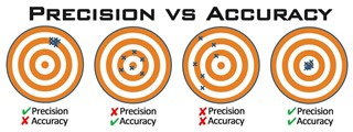
  • @a_c:  Can you provide the link to the graphic comparing Precision and Accuracy?

  • Tom reminded me of some related items that I've mentioned previously.

    1.  In the you 66i's System settings for Recoding set it to record GPX, in addition to FIT, and set Recording Interval to 30 seconds.  Find a walkable flat and level place start recording and walk about 5 minutes, then turn around and walk back to start and stop recording.  When back, connect the 66i via USB to computer and download the GPX file,  If you wish, make a copy and reload the original file.  With either Notepad or Wordpad app, go through the file and subtract each elevation point from the succeeding and then add all the intervals up.

    2.  Find a place where you can walk either up or down a steady incline without dips, sonstant up and down.  Start recording and then go either way for at least 50 feet of elevation change recording about 10 points.  Then turn around and go back to your starting point and cease recording.  When back, open the GPX file and add up alll the intervals for the up points (total ascent) and all the intervals for the down points (total descent).

    Conclusions

    Flat walk:  The total of all the intervals should be essentially zero.

    Hill walk:  The magnitudes of up and down, total ascent and descent, should essentially equal.  The sum of all intervals, positive for up and negative for down, should be essentially zero.

    For both flat and hill, if the total sum is not zero as displayed on the unit, I can see no conclusion except for software error.  Note, all errors in the individual elevation readings should essentially cancel out upon summation.