how can i record lat/long datas on my session result

Hello.

i want to know how can i write lat/long data on my session result.

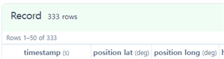
i can read lat/long datas on fit file and see a map on Connect App when i use app from 'walk'. 

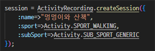
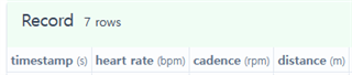
but i made an app it didn't record lat/long datas and cannot see a map on Connect App


how can i record lat/long datas and see a map on Connect App.

Thanks.

  • I don’t think so. It’s a catch-22 bc you can only determine GPS quality if GPS is enabled, and if GPS is enabled its data will be recorded (if your app is recording.)

    The best you can do is:

    - display GPS quality in your app and allow the user to make the decision to start the recording when GPS quality is good enough. (Or even prevent them from starting the recording unless the quality is good enough, but that might be seen as user hostile). Note that even in native Garmin activities like Run, a green GPS ring (which should correspond to GOOD) is a total lie in some cases. Especially if you’re around tall buildings, you will see your pace fluctuate wildly for a few seconds (or even minutes) when you’re standing still and you have a green ring.

    - record GPS quality to the FIT file as a developer field

  • In my apps, I don't allow starting to record until there's good GPS.  That's confused a few users over the years, but when I explain, the users seem to be OK with that.  The quality is already in the fit file or the location stops being recorded.  If for example, you are recording and go through a tunnel, the quality drops and your time in the tunnel is just a straight line from enter to exit.  You won't see this in the sim replaying a fit file, as in the sim you set the quality you want to see.  In one of my apps I have a whole screen about GPS, showing the current quality, and things like the start location, and distance from start to current location.