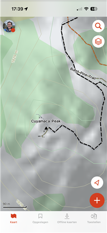
Lack of details on "Topo" map in iOS Explore vs. Explore Website

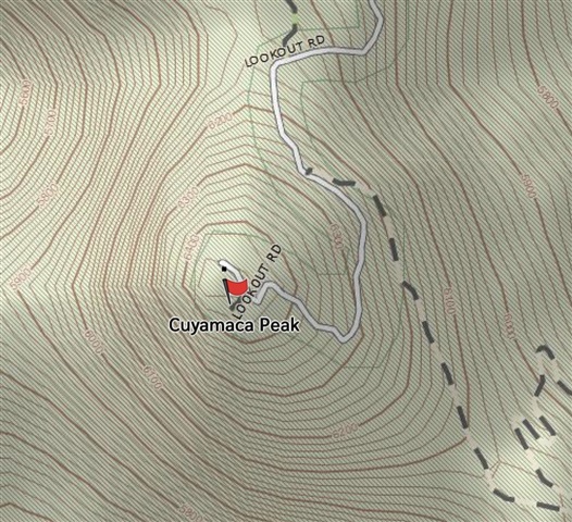
Here's an example of the map detail I see in explore.garmin.com/Map  - this location is Cuyamaca Peak in San Diego County:
Compared to the detail I see inside the Explore iOS app 
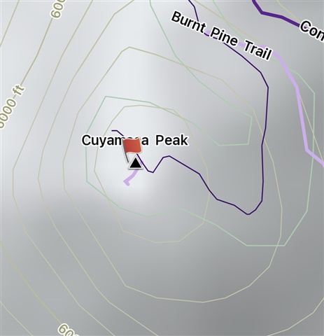
There is just a ton more detail in the Web map vs. the iOS map.

Is this something that I can fix?  Is this lack of detail something that https://www.garmin.com/en-US/p/893561/ improves?

  • Outdoor Maps+ will give you additional map layers on top of the default TopoActive maps in Explore app (and on a compatible Garmin device). Note that Explore web uses different mapping and is not compatible with Outdoor Maps+.

    As for an example of what the map in Explore app looks like with Outdoor Maps+ layers turned on, see this screenshot:


    This is with additional layers for buildings, tree species, contour lines and contour shading.

  • Thank you for that example.  There's more detail in what you are showing, but I still like the Web version best of all (one detail: it clearly shows that the trail to the peak is actually a paved road, vs. just a trail).   

    It's confusing with all these map options which differ between mobile and web versions.

  • Yes it is extremely irritating and I know of no solution, certainly not one that avoid spending lots of money to replace the old version of Explore that "just worked".  Add to this, their new fancy routing engine is broken for many trails that also used to "just work", and can no longer intelligently route on many common hiking trails here in California.  Garmin did us a major disservice by breaking these things, and they've been broken for years now.

  • With the Outdoor plus, are the maps more detailed in the explore App? I bought the Mini 3 and I’m wondering if I’ll need to use the phone for the high detailed maps.

  • The Explore website can display more detailed map information, while the iOS app uses the default TopoActive map. If you want additional detail in the Explore app, Garmin’s Outdoor Maps+ subscription adds extra map layers, including contour lines, contour shading, buildings, and other geographic information.

  • Sure, we can now *pay* for the detail that we used to get for free in the app.  The default topo is simply inadequate now for hikers and backpackers, and it didn't use to be, and we shouldn't have to buy an uber-expensive watch and then also have to pay extra for good quality topographic lines on the companion app.

  • Map errors can be reported through the iOS app via the upper-right layer symbol > Report a Map Error. This is not a problem specific to this location, but rather a general issue. Nevertheless, reporting it could help make Garmin aware of it.

    The error report could be worded like this:

    “The road is correctly present in the map data, but is rendered extremely faintly and is therefore almost invisible at this zoom level. The same road was previously much more visible when it was classified as highway=track. It is now classified as highway=service.”

    I have a theory about what changed with Explore 4.x. In OSM, this particular road was still tagged as highway=track in 2015. It was later changed to highway=service. The map data used on the Explore website appears to be much older, so it may still contain the old track classification, whereas Explore 4.x uses newer map data and therefore sees it as a service road. Garmin may render highway=service, and especially service=driveway, very faintly because these roads are of little relevance for car navigation. However, they can be quite important to hikers and cyclists. So the change in visibility may simply be a consequence of how Garmin renders the newer OSM classification, rather than any change to the road itself.

    With regard to JungleJim’s Maps+ screenshot, the better visibility of the road in this particular example appears to come from the Garmin Trails map layer. A Garmin Trail has been created along this road, and the Trail layer draws a much more visible line on top of the underlying road. This does not mean that the Garmin Maps+ Trail layer generally solves the road visibility problem. It simply makes this particular road look more visible because a Garmin Trail happens to be mapped there. At other locations, where there is no Garmin Trail, the same type of road can remain extremely faint or almost invisible.

  • With regard to JungleJim’s Maps+ screenshot, the better visibility of the road in this particular example appears to come from the Garmin Trails map layer. A Garmin Trail has been created along this road, and the Trail layer draws a much more visible line on top of the underlying road. This does not mean that the Garmin Maps+ Trail layer generally solves the road visibility problem. It simply makes this particular road look more visible because a Garmin Trail happens to be mapped there. At other locations, where there is no Garmin Trail, the same type of road can remain extremely faint or almost invisible.

    For this screenshot the Garmin Trails maps layer wasn't turned on. I don't have an OM+ subscription at the moment so I can't check, but if I remember correctly the trails from that layer are shown in red.

  • the black trail on top of the service road comes from the Garmin Trails layer. Switching it on and off the black line comes and go. It’s black because its difficult. Easy trails are blue and medium trails are red. Just like skiing lines or trails in a bike park.