Export to KML from Garmin Connect

When I export a track from Garmin Connect to KML and then import it to Google Earth I lose a lot of detail. The track becomes a series of straight lines. If I export to GPX and import the GPX file to Google Earth, I get full resolution. Is there any way of increasing the resolution of the KML file or is this built into the Connect software?

  • Are you exporting an activity, choosing the option "Export to Google Earth"? If not, can you describe your workflow in more detail? I do this on a daily basis. I do not lose any detail. The track looks the same as it does on Garmin Connect. Can you zip then post your fit file here so we can take a look?

  • I download my activity from a Garmin 910XT to Garmin Connect, I then "Export to Google Earth" and import the resulting KML file into Google Earth.

    I cannot se a way to attach a file to this message

  • I cannot se a way to attach a file to this message
    • Zip the file, then in a reply post Insert >> Image/video/file >> click Upload >> browse for file >> OK.
    • Or upload the fit file to a reputable file sharing service, such as OneDriveGoogle DriveDropbox, make the file public, then paste a link to the file in your post.
  • This looks fine...

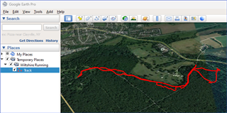
    I uploaded the fit file to Garmin Connect then "export to Google Earth," Opened the kml, which opens Google Earth, then cropped out all except the track.

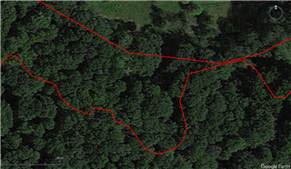
  • I have no trouble opening the file in Google Earth. However, if you zoom into the track, you will see that it is composed of straight lines. See my screenshot. If I export from Garmin Connect to KML and import the KML file into Google Earth, I have no such problem. The issue appears not to be  with the original FIT file but rather with the way the file is converted to KML in the export routine.
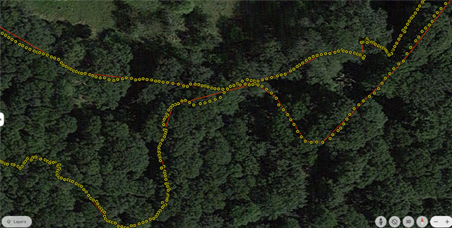
  • I exported you activity as KML as well as GPX, and both of them have practically the same number of trackpoints. The KML file has in fact very slightly more of them - 3122 vs 3118 at the GPX file. So the resolution of the exported files is the same at both file formats.

    When I import the KML file to Google Earth, the track shows all those trackpoints (yellow circles). however, unlike as at the GPX file, in the KML format, the trackline (red) is declared separately, and in this case the declaration contains only 206 waypoints (optimized for the navigation). I do not think there is a way to change it in Garmin Connect, so I recommend either using the GPX format, or using the yellow trackpoints, and not the red trackline. 

  • Your findings agree with mine. I was wondering if there is a software setting in the generation of the KML file that declares the resolution for the trackline? It seems odd that the trackline does not just join up all the individual waypoints. In effect this seems to be the equivalent of the setting on my 910XT where I can choose "Smart Recording" (points recorded when there is a change of direction or speed) and "Every Second" - the latter being the one that I routinely use. If you look at the KML text file, the coordinates for the trackline are given at the top of the file:

    </description>
    <Placemark>
    <name>Track</name>  

    <coordinates>-

    These coordinates are entirely separate from the </Point> coordinates, which are declared lower down in the file.

    Clearly the program that generates the KML file in Garmin Connect is generating a low resolution track line for reasons that I cannot understand. 

  • I was wondering if there is a software setting in the generation of the KML file that declares the resolution for the trackline?

    No, there is not

    It seems odd that the trackline does not just join up all the individual waypoints.

    Not really. The trackpoints (yellow) are used by Garmin to design the path in good resolution. The waypoints are used for the navigation (change of directions). Using thousand of waypoints would overload the devices. Some of them are not able to process more than 30 waypoints, some have the limit at 50, 100, or 200. The limit of Garmin Explore is 200 points. For the navigation it is fully sufficient, and for the detailed path in high resolution, the trackpoints are used.

    There is no relation to the Smart and 1s recording, in this case, except that at the Smart recording the number of trackpoints (yellow), could be lower.

  • Any limits to Garmin devices should surely be irrelevant. The export routine is labelled "Export to Google Earth". This is so that one can view one's route using that software. For navigation I can create a course with full detail in Garmin Connect and if I am transferring route information to an external device I would probably use GPX or TCX formats rather than KML which is tailored for Google Earth. There is a plethora of software that one could use to reduce the number of points if needed but, as I said, I don't understand the reason for degrading the track resolution at the outset. Clearly this is built in to the file generation routine and I don't suppose that Garmin will change it. I can, of course, import a GPX track into Google Earth with no loss of detail but it does seem counter intuitive to not use the file intended for the purpose.