This discussion has been locked.
You can no longer post new replies to this discussion. If you have a question you can start a new discussion

Course routing not up to date with a previously closed walkway

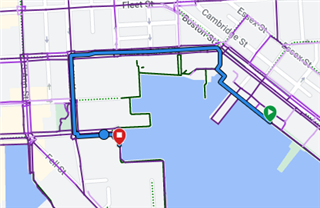
There's a waterfront promenade in my city that is a popular walking/running path. One section of it was closed for a few years (starting around 2020), but has been reopened for a year or so now.

Connect shows the section as green, indicating it's a path, but the purple heatmap isn't present. Don't know if that's an error, or a result of being closed for a couple years and not having the popularity tracked?

I can use the freehand mode as a workaround to force the route to be in this area and create my course. But this issue should be more permanently fixed. A screenshot of the section in question is below, it is near 2001 Aliceanna St, Baltimore, MD. I chatted with support, and they suggested the freehand mode workaround, but couldn't do anything else regarding a real fix.

Is there any other way to submit a ticket to get this addressed?
  • The HeatMap is based on OpenStreetMap data.

    So as first you need to update OSM, then wait until Connect decide to copy it (they do it rarely).


    The data on OSM match your description.

    note = Closed for construction project at 2001 Aliceanna Street.
    opening_date = 2022-06-23

    access = no
    check_date = 2021-12-26
    construction = cycleway
    highway = construction


    So as construction is completed - you need to change all parts of this path to open by removing access=no (or set to yes) and by removing construction=*. You can set current check_date=2023-06 or remove it, and set a correct path's type - depending on traffic sign:


    officially designated for both (person & bicycle sign)

    bicycle = designated
    foot = designated
    highway = path
    segregated = yes / no (if there is a line on the ground for separation)


    official cycleway (bicycle sign)

    foot = yes (if foot is allowed, but doesn't have priority)
    highway = cycleway


    official footway (person sign)

    bicycle = yes (if bicycle is allowed, but doesn't have priority)
    highway = footway


    or if no official signs - simply:

    highway = path


    Other present tags - keep or update as needed:

    lit = yes
    name = Baltimore Waterfront Promenade
    surface = concrete
    width = 2 (in meters)

  • Thank you so much for the detailed response!

    I've went through and made the changes, now just a matter of waiting for garmin to update

  • Good, though you missed the last part (the shortest), it's still with access=no, so routing will stop there. Also you can remove note=Closed for construction to make it clear that it's open.