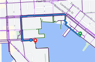
There's a waterfront promenade in my city that is a popular walking/running path. One section of it was closed for a few years (starting around 2020), but has been reopened for a year or so now.
Connect shows the section as green, indicating it's a path, but the purple heatmap isn't present. Don't know if that's an error, or a result of being closed for a couple years and not having the popularity tracked?
I can use the freehand mode as a workaround to force the route to be in this area and create my course. But this issue should be more permanently fixed. A screenshot of the section in question is below, it is near 2001 Aliceanna St, Baltimore, MD. I chatted with support, and they suggested the freehand mode workaround, but couldn't do anything else regarding a real fix.
Is there any other way to submit a ticket to get this addressed?


