This discussion has been locked.
You can no longer post new replies to this discussion. If you have a question you can start a new discussion

No route is displayed without authorization

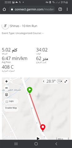
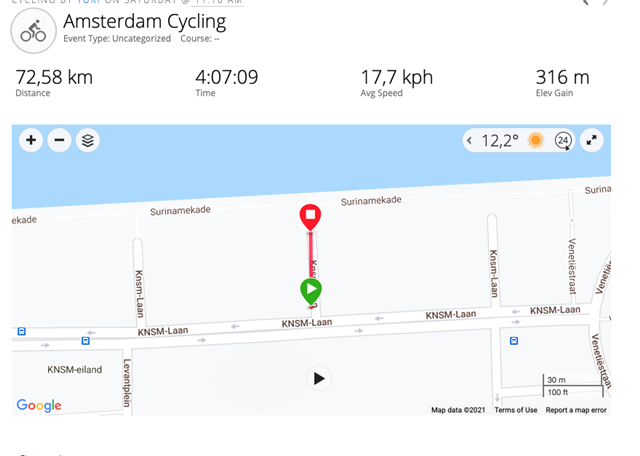
When I open my public activity without authorization, I see only 2 points instead of normal track. Seems like a bug.

Example of my activity: connect.garmin.com/.../6326524783

And that's what I see.

  • This is a new behaviour hiding data from non-members, or from users not signed in. It also prevents the direct viewing of diverse JSON background data. It was already discussed in several threads. For example:

    It will be interesting to know whether it was an intentional measure, or rather an accidental side-effect of the added security, so let's wait what they tell to 

  • SUPPORT CENTER CHAT

    Session started between Kevin and seilogramp.

    • seilogramp: When viewing my public profile I can see my full activity map on the profile main page. But when opening one of the activities, the map only displays the start and end points.
    • Kevin: OK, I'm looking at a few of your activities. I see the entire GPS track of your activity.
    • seilogramp: You will see it if you're logged in with a Garmin account. You will not see it if you're logged out. You'll just see the start and end points.
    • Kevin: Let me send you an email of what I see. Why don't you send back screenshots of what you see.
    • seilogramp: Just replied with screenshots
    • Kevin: Thank you. Let me check.
    • Kevin: Ok, reaching out to my Help Desk
    • Kevin: Looks like we may have some other reports of this.
    • Kevin: I have you added to a case we have open for this issue. Once we make a fix to the Garmin Connect website to resolve this issue, we will notify you via email.
  • The issue has been raised to the garmin & I am waiting for them.

    Thank you  for the detailed report and for reporting to Garmin Support.

    To keep focus on one thread, I'm joining these threads to this pinned thread.

    No route is displayed without authorization

  • There is no reply from garmin until now Disappointed 

  • A polyline is available in those two links.


    The first link is - currently - available only for logged-in users. Others get 403 Forbidden:

    connect.garmin.com/modern/proxy/activity-service/activity/ACTIVITY-ID/details?maxChartSize=2000&maxPolylineSize=4000


    The second link is accessible by everybody if an activity is public:

    connect.garmin.com/modern/proxy/activity-service/activity/polyline/ACTIVITY-ID

    You can copy encodedSamples from it, remove escaped characters (replace double backslash \\ by single \) and draw polyline on http://geojson.io -> Meta -> Load encoded polyline.


    Currently, Connect Web uses the first link. For a test - I redirected it to a file saved locally - and then polyline is displayed normally. So to fix this problem: the site only needs to add permission for not logged-in, or read polyline from the second link.

  • So to fix this problem: the site only needs to add permission for not logged-in, or read polyline from the second link.

    I may be wrong, but personally, I suspect that the change was intentional from the side of Garmin, with the purpose to reduce the huge load, all these polyline (and graph!) data transfers cause when the GC pages are being crawled by spiders and bots (and by non-member humans as well).

  • Hard to guess. Changing permission shouldn't happen by mistake, so it could be intentional. But on other hand: the website is still trying to load that data and a map looks bad without it. Maybe they plan to use the second link containing only a map polyline without charts. Either way they have fix to do.

    To lower a transfer, they could also list less points of polyline, the first link seems to have this feature.

  • Lack of permission to details affects embed activities even more.

    https://connect.garmin.com/modern/activity/embed/ACTIVITY-ID

    Activities with a map - as embed are totally empty for not logged-in. After failed try to load a polyline, it just stops loading, leaving a blank page. So, an user doesn't even know there should be something in that place on a page.
    Currently it works only for activities without a map.

  • Former Member
    0 Former Member over 4 years ago

    My Garmin has no problem tracking my cycling routes and my Connect app is also showing the routes correctly. But when I share my routes by creating a web link, people I share with can only see a straight line on the map! My routes are always a loop so I don’t even know how the other end of the straight line is determined. This was definitely not the case before but I really can’t remember how I messed up with the settings. Does anyone know how I can share my routes properly again? Many thanks!

  • Does anyone know how I can share my routes properly again?

    Known issue...

    SUPPORT CENTER CHAT

    Session started between Kevin and seilogramp.

    • seilogramp: When viewing my public profile I can see my full activity map on the profile main page. But when opening one of the activities, the map only displays the start and end points.
    • Kevin: OK, I'm looking at a few of your activities. I see the entire GPS track of your activity.
    • seilogramp: You will see it if you're logged in with a Garmin account. You will not see it if you're logged out. You'll just see the start and end points.
    • Kevin: Let me send you an email of what I see. Why don't you send back screenshots of what you see.
    • seilogramp: Just replied with screenshots
    • Kevin: Thank you. Let me check.
    • Kevin: Ok, reaching out to my Help Desk
    • Kevin: Looks like we may have some other reports of this.
    • Kevin: I have you added to a case we have open for this issue. Once we make a fix to the Garmin Connect website to resolve this issue, we will notify you via email.