
1. Garmin has a very low sample rate (amount of points on a route). On a picture below comparison of 7 segments.

Results of comparison:
- Garmin’s average distance between two points: 55-230 meters.
- Strava’s average distance between two points: 3-12 meters.
- Garmin’s maximum distance between two points is ridiculous: 1030 meters.
I have faced with common problems:
- I can’t create a favorite segment which ends at the road cross, because nearest points are located before or after the cross on a 50-100 meters away from it.
- I can’t create a favorite downhill segment because there is no point exactly at the end of the hill.
- I can’t reproduce segments from Strava, because Garmin does not provide me the same points on a route or with a reasonable difference in distance between them.
How is it possible to create a segment with enough precision if you have such big distance between points? It is hardly possible.
2. Altitude graph does not have a scale to a selected part of the route. Which makes not possible to be sure that you start the segment exactly at the beginning of the climb and finish the segment at the end of the climb and vice versa.

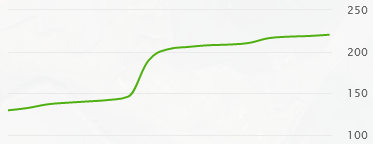
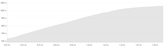
3. Altitude profile of just created segment does not have anything with a reality.
Garmin
Strava
4. Finally, Garmin does not provide us the possibility to edit a segment. You can’t edit a segment and you have to start from scratch and create a new segment and remove the old one.
5. Additionally, sometimes, just created segment is not attached to the sourced activity. Is there some limit of segments per activity? Or is it a matching issue due to bad points?
Is there any other issues you know?


