This discussion has been locked.
You can no longer post new replies to this discussion. If you have a question you can start a new discussion

Garmin Connect Courses elevation gain grossly overestimated.

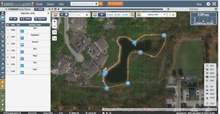
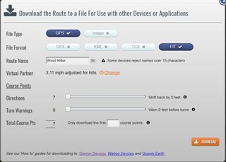
When creating a course on Garmin Connect the elevation gain is grossly overestimated. I can download the GPX and upload to other programs (e.g. strava) and the courses match reality. It is very large over estimate of 30-40% and obviously wrong by inspecting the plot. Anyone else seen this and is there a fix?

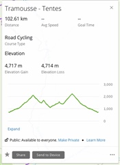
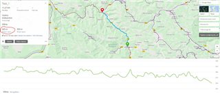
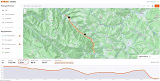
Note same file in Strava is approx 3200m elevation gain.

  • And did anyone of you report the problem to Garmin, providing them the relevant data? What was their answer?

  • OK, there is a solution for you, here - it works both for the right elevation profiles as well as for the turn-by-turn navigation:  Plotaroute.com

    Create or import your route there (GPX import is accessible on the top left with the option Create » Upload). Then save it as a FIT file, incl. the navigation waypoints (see the option D'LOAD on the tool panel down right), and then upload it over the USB cable  directly to your device. No app on the device needed. You just need a free account at Plotaroute.

    More details in the post from  on the Garmin Instinct forum:

    Use Plotaroute.com.

    Create a route and add navigation info where you like.  Save a .fit file then copy into the \Garmin\newfiles folder of your device while connected via USB.  See screenshots below.  I provided another link where I learned the technique.  

    Further reading:

    https://forums.garmin.com/outdoor-recreation/outdoor-recreation/f/fenix-6-series/192222/next-waypoint-and-distance-to-next-showing-distance-to-next-turn/935771#935771

  • if i use the workaround via komoot connect iq app or strava app or posting the course to new files this does not happen.

    thanks for taking the time and showing this alternative service. This is possible. This makes the new sync option useless though (or Garmin Routes altogether for that matter). I just   Got to the Problem via testing the new features of syncing routes from strava, Komoot, ridewithgps to Garmin. I will open a new ticket on the weekend when I have some more spare time. 

  • Thank you for providing this workaround. Anyway, it's still a workaround, not a solution, which needs a third party platform to make something basic to work. I will use it, as I have no other solution if I want to have both TBT and the correct elevation data but, as you suggested, I opened a ticket with Garmin on the issue and I invite everyone else interested to do the same. 

  • I also opened a ticket with the garmin support.

  • I have encountered the same problem since about 6 months. When I create a course on Garmin Connect the elevation gain is grossly overestimated. The same problem when I save in Connect a course from other source like Alltrails,Wikiloc etc. I confirm the over stimate elevation is about 30%. There are about five years that I use Connect on web and the problem arose about 6 months ago. Thank you

  • Hi, I have the some issue:

    this is the Activity registered with Garmin 810 (elevation gain mt. 1155 true):

    https://connect.garmin.com/modern/activity/5054661242

    this is the same Activity saved in Garmin Connect Web as Course (the elevation become mt 1668):

    https://connect.garmin.com/modern/course/34826845

    Thank you for yr help

  • this is the Activity registered with Garmin 810 (elevation gain mt. 1155 true):

    Actually your case is different. The elevation gain reported by the Activity is far below values shown by diverse GPX tools. The elevation gain they show is much closer to the elevation gain shown by the Activity saved as Course. The differences among the diverse programs come from the differences of filtering fine noise in the data - each tool filters small changes a bit differently, or uses a different sampling rate for the keypoints of the trail. However, the Course in your case is likely right.

    Edge records the elevation profile with the help of a barometric altimeter, whose accuracy is influenced by a number of factors: proper calibration, atmospheric pressure flucuations, hysteresis and speed of response of the pressure sensor, wind, wind gusts (inluding air flow during fast descents), temperature, dirt and water entering the pressure sensor orifice,...

    Typically, the elevation profile shown when you enable the Elevation Correction (below the watch symbol on the right side of the Activity page) is closer to the reality than the profile from the barometric altimeter.

  • This issue is really annoying ...

    A test route created in GC: elevation gain 303m, elevation loss 359m

    The same test route created in Strava: elevation gain 37m, elevation loss 90m

    Still no answer how to solve it?

  • From all that I have read here in the forums, this issue has been there for years in all kind of different devices and seems (to me) to be a global algorithmic problem when importing course data. I do not currently think, that it can be solved as a user. 
    That’s why I opened a support ticket with garmin support. I don’t think that officials are reading here in the forum - although I put a link to this thread and other in my email to support. 
    i would advise and encourage you to also open an official ticket with support (phone, chat or mail) and again tell them this issue. 
    for now there are only the aforementioned workarounds.